Category Archives: Within a radius of about 50 miles

Almondell Country Park

Another saunter in Almondell Country Park

This is another figure-of-eight walk around the glorious country park of Almondell.

Starting Point

Livingston, Scotland, United Kingdom

Getting to the park is very simple and should take about 50 minutes from Glasgow. Leave Glasgow on the M8 heading east towards Edinburgh and stay put for about 30 miles until JUNCTION 3 (not Junction 3A which you come to first) where you leave on the left to take the A899 to Livingston (and West Calder). You swing around the slip road, back over the motorway and come to the roundabout with a whalebone structure in the centre. Take the first exit down the main Livingston dual carriageway but after 800 yards take the road to the left sign-posted Pumpherston and Uphall Stations. (There are a pile of Livingstone estate names – ignore these!). You come down to a main road where you turn left and at the roundabout also take the first exit on to Houston Road and the Houston Industrial Estate. At the traffic lights, go straight on – now sign-posted for the Country Park.

Go past a new housing estate and then travel about a mile along an increasingly countrified road to a cross-roads. There’s a big sign to Broxburn pointing left, a country road straight on but the sign for Almondell Country park is hidden until you’ve actually turned right! Drive down this single-track country estate road till you come to the Estate Entrance. Go past the North car-park, through the two-pillared Estate entrance, and down the drive past the Visitors’Centre. There are toilets here – and for once, we’ll have coffee!

The walk: First Half 3.25 miles

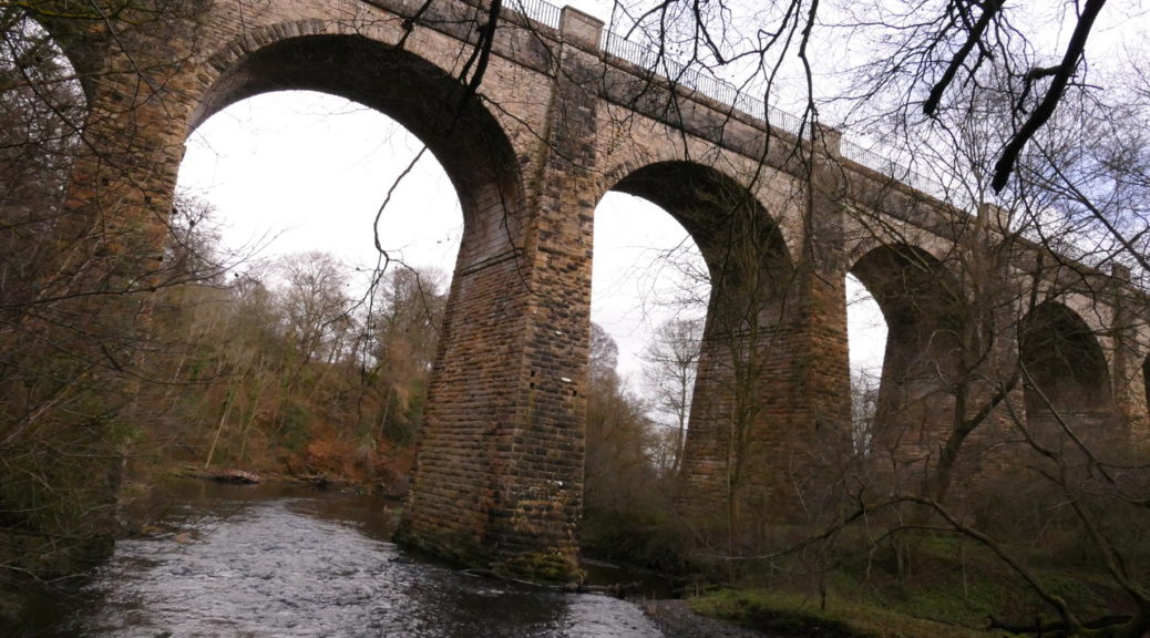
Go down to the river’s edge and turn right along the river to the magnificent Nasmyth Bridge which you cross, taking the main drive up to the South Car Park. Here  turn right for a short distance and then re-enter the park to walk through open farm land to the Camps Viaduct and the wonderful views of the River Almond below. Instead of taking the steps down , continue along what was an old miners’ path for about 0.7 miles, turning left at a junction of paths, through a gate and continuing through open farmland. This takes you along Powies’ Path (a track) to good steps back down to the main path in the Country Park. Turn left here picking up the canal feeder (see Second Half). Go under the viaduct and through a curious structure to protect walkers from anything falling from aloft. Cross a bridge over the River Almond with the canal feeder under the footway. A good path takes you back to Nasmyth Bridge and the Visitors’ Centre where you might have lunch.

The Walk cont: Second Half 3 – 4 miles.

After lunch go back down to the river and turn left to the Mandella Swing Bridge. A short, steep climb takes you up to the canal feeder again. This is a flat walk, in good condition, with lovely views across the River Almond and with the water running along beside you There are several stiles and one short very muddy stretch.

The path brings you to a set of steps which are in the care of Edinburgh Council  and difficult. If you prefer, you can cross the canal feeder at the sluice gate before this and climb up past a caravan site to West Clifton. The track emerges at Clifton Road where you turn left, At the junction turn left again and walk along a country road.  At an obvious sign-post gusset take the left track and it will by-pass the difficult steps and take you to  the Lin Mill Aqueduct,  with magnificent views across the valley.

If you want to go under the canal to the other side, either return to a path sloping down or go down the stone steps (with a rail) immediately beside the stone wall of the canal. Then go under the canal and at some very tall gates, go up the stone steps on the right to bring you to the other side. Come back the same way – whichever way you choose although the difficult steps and more difficult going down!

To get home, go back up the main drive to the entrance, turn left and go back the way you came to the Houston Interchange. Go straight on following blue signs to the M8 to Edinburgh and Glasgow. At the slip road on the left, signposted M8, just on the bend, watch for traffic coming from the right, and again on the dual carriageway. You don’t have right of way. Come back to the roundabout with the whalebone structure and take the second left to the M8 to Glasgow.

The West Highland Way: Crianlarich to Ardlui

This is a straight-forward walk along the West Highland Way from Crianlarich to Ardlui. For aficionados of the WHW, it’s good to be looking in the opposite direction for once, since most people walk towards Crianlarich. Your views will be down the Falloch Glen towards Ben and Loch Lomond.  And although you won’t think this at the time, apart from the climb up through the woodlands at the start, you are gently going downhill all the way!!!

If you are eating at The Ardlui Hotel afterwards, you will probably get permission to park at the car park on the left-hand side of the A82 at Ardlui Hotel NOT in the hotel car park. To get there, take the A82, Great Western Road, as usual, (Boulevard, Dumbarton, up Loch Lomondside). Make sure that you follow the A82 round to the right at Tarbet, rather than going straight on up the A83. Along this often twisting narrow road, note Ardlui Station on your left, the marina on your right, Ardlui Hotel on your right and a large layby on the left. If this is full, there is a large car park next left. Both of these areas belong to the Hotel and are not for public use.  There is a shop opposite the layby selling sandwiches and drinks etc. There are excellent toilets at Firkin Point and Tarbet and you would be best to use these. There are toilets on the train but you only have one stop! There are toilets at Crianlarich but they are slightly off your route.

Arrochar G83, UK

Begin by walking back down the road from the car park at Ardlui towards the station. There is an excellent off-road path for walkers although crossing to the station is awkward. The journey lasts 16 minutes and you get out at Crianlarich. A set of steps leads directly on to the road and the WHW is signposted to the left. You begin with a climb up on to the path since the WHW officially by-passes Crianlarich. Take this very gently: the path is good and there are no steep climbs but it does go on a bit. At the top, take the WHW towards Glasgow (NOT Tyndrum!). Then follows an idyllic seven miles on an excellent track looking up at Ben More, across to the Old Caledonian Forest and down the Falloch Glen. At one point there is a sharp turn to the left, taking you steeply down to an underpass underneath the A72. There follows some really pretty bits along the river although you hear rather than see the Falls. Derrydoch Bridge is delightful! The path is universally good underfoot, varied but busy. Simply follow all the WHW signs.

At Beinglass you might want to stop for a drink, ice-cream whatever, along with about 3,946 others!!!! If you want to leave here, you could take the bus. The bus is either No. 914/915/916 and runs from the Drover’s Inn to Ardlui Hotel (about 5 minutes) at 14.40 15.40; and 16.40.

Otherwise you plough on for another two miles, making 9 miles in total. The last two miles are quite tough!

At the ferry at Ardleish, the fun begins!!! You need to hoist the orange buoy! The sail across Loch Lomond is lovely! The fare is currently £4 per person. Remember to lower the buoy before you cross. You arrive back at the Ardlui Hotel.

South Queensferry to Cramond return

What with two and a half iconic bridges, Robert Louis Stevenson’s ‘Hawes Inn’ which is mentioned in ‘Kidnapped’  and the islands of the Forth (Inch Garvie, Long Craig, Inchcolm, the Cow and Calves, Inch Mickery and Cramond Island itself) this is a most photogenic walk. If you have never been to South Queensferry you’re in for a treat just driving through the cobbled streets: throw in Dalmeny House from several angles, Hound Point and Barnbougle Castle,  a couple of picturesque cottages  and the view of Cramond from the beach and you have a perfect day.  It’s very easy walking on LRTs and lovely paths beside along the shore all of which are firm packed. The round trip is 9 miles but  you can turn back at any point, lie in the sun, or go for a coffee in South Queensferry.

 Park in the car park facing the River Forth, at the far end of South Queensferry, almost underneath a stanchion of the rail bridge and just before The Hawes Inn (highly recommended!). As you leave the cobbled winding streets of South Queensferry behind, enter the car-park on the left – it’s one-way. There are toilets opposite.

South Queensferry, Edinburgh EH30, UK

To get there: Satnav Post Code: EH30 9TA for The Hawes Inn
Getting there is very easy until the last 3 or 4 miles! The mileage and timing seemed about the same which ever route you take  at about 55 minutes and 44 miles, although  (as of May 2016) there are road works on Route two – the M8. In any case Route One is easier to follow with wonderful views of the new bridge.

Route One:
Take the M8 east (towards Edinburgh) from Glasgow and then the M80 to Stirling, Kincardine Bridge etc. After about 15 miles take the M876 to Falkirk, Grangemouth etc. DON’T TAKE THE FIRST M9 GOING OFF TO THE LEFT – this is the wrong direction. Stay on the M876 and then move over on to the M9 while the M876 goes on to Kincardine Bridge. (You’ll hardly notice that you’ve now joined the M9.) Stay on the M9 for about another 15 miles until Junction 2 with the B8046, when a brown tourist notice takes you left, advertising Hopetoun House. At the end of the slip road turn left on the B8046 and at the T junction, turn right on the A904. Drive for about 4 miles through Winchburgh, Newton etc, Almost immediately after an elongated roundabout turn left on to the B924 to South Queensferry (Bo’Ness Road then Hopetoun Road) which goes underneath the motorway above. Continue to follow the B924 (Hopetoun Road) through the outskirts of South Queensferry. At a very awkward junction, turn left onto Newhalls Road (still the B924) which ducks and weaves through the town.

Route 2:
Take the M8 towards Edinburgh but stay on the M8 for about 37 miles until you reach the M90/M9 signposted to the Forth Bridge (A90), Stirling (M9). Watch that the slip road comes up on to the M9 rather quickly. Continue on the M9.

At Junction 1A take the A90 exit signposted to Perth and Dundee. This is a huge curve round to bring you down on to the the M90 below. Continue on to M90.  Continue to a very large roundabout where toll traffic for the bridge goes straight on.  Go right round and take the third exit, B800, Ferry Muir Road, towards Kirkliston. At the next roundabout take the 1st exit on to Kirkliston Road, B907. Continue to follow the B907 down past Dalmeny Station etc. At a very awkward junction, turn right onto Newhalls Road (B924) which ducks and weaves through the town.

The Walk
Your walk is simple! From the car park  continue in the same direction, past the pier for Inchcolm on the left, and The Hawes Inn on the right (dating back to the 17thc.), and the Forth Rail Bridge above (completed in 1890)! Don’t go up the hill with the road but hug the shore line with fantastic views of the three bridges.

The first quaint white-washed building on the left was once a World War I gun emplacement, then a tearoom and is now an office. With woodland on your right and the river on the left you soon enter the Dalmeny Estate and approach Long Craig Pier which used to be one of the ferry crossings across the Forth. (There were several such piers and crossings depending on the tide.) It might be worth doing this to take photos.

Go through the white gate beside ferry cottage as you continue towards Hound Point. Just before, at Peatdraught Bay, is the first delightful alternative. At a clear junction with three huge tree-trunks,  take the firm path to the left down nearer to the shore and into a grassy knoll. This is lovely. It re-joins the main track at five huge tree trunks which you should look for if you want to take the diversion on the way back.

The Estate notes say: ‘It is worth taking a detour onto Hound Point headland, which, according to folklore, is haunted by a dog owned by Sir Richard Mowbray who died on the Crusades. The views from Hound Point are magnificent. There are numerous points of interest including Inchcolm Island with its old abbey and the Forth Bridge. Opposite the turning to Hound Point and up the hill within the woodland are the remains of World War I gun emplacements, part of the Forth naval defences.’

Continue past Fishery Cottage (so-called because salmon was fished from here until the 1950s). The next significant point is Barnbougle Castle, restored and privately owned. And difficult to photograph from here – there are good views looking back from further on!!! Again, the Dalmeny Estate notes say: ‘Barnbougle Castle may be glimpsed through the trees. The castle is on the site of a medieval tower house built by the Mowbray family which was destroyed and then rebuilt in the 19th century. At Barnbougle the fifth Earl of Rosebery (Prime Minister) practised his speeches in a gallery hall built for the purpose.)’

 Just beyond Barnbougle Castle  you come to a golf course and your first view of Dalmeny House. (The view was excellent but even better on the return leg.). At the corner, unexpectedly, and with the main notice lying on its back, is a John Muir Way signpost showing that cyclists should continue on the road but walkers should turn sharp left to walk along the river. This is a wonderful improvement. The path goes straight down to the river (and a lovely tree trunk to sit on) then sharp right along the river bank. At the end the path continues through the woods going slightly inland to cross the briskly flowing Cockle Burn on a sturdy footbridge beside a rotting seat! The path emerges on a track beside some picturesque cottages (Long Green Cottages which were built for estate workers) and then continues on to rise slightly with lovely views of Snab Point, the river and Arthur’s Seat. There is a huge boulder here where you might stop for lunch. Continue on to Eagle’s Rock and then come to a full stop!

The way ahead and around Cobble Cottage is blocked but it is worth taking to the beach at this point just to look at Cramond. Unfortunately, at the time of writing, there is no way of getting across the River Almond. After viewing the river(s) and the village, return to the sharp turn in the path where the John Muir Way turns sharp right and you went left on to the beach.

Follow the JMW uphill a short distance and take the JMW cycle route inland but higher up. This is well worth doing, not least for the better views of Arthur’s Seat and even across to Scald Law and the Pentlands. This path comes to a crossroads with lots of alternative walking routes. But you may as well stay with the JMW through Long Green to the Estate Road going down to Dalmeny House. There are spectacular views of the house.  Again, the notes say: ‘From the golf course there are beautiful views of Dalmeny House which was built in 1817 to a Tudor Gothic design by William Wilkins. A rare type of artificial stone called Coadestone was used in the more decorative elements on the house such as the finials and panels on the façade. The house was used as an auxiliary hospital during WWI and during WWII the stables to the rear were used by the Army for a Barrage Balloon Unit. The house was damaged by fire during WWII, evidence of this can be seen in the use of a new copper roof on the southern wing of the house.’

Here re-join the outward stretch and retrace your steps to South Queensferry.


Arran, The Clauchland Hills

This is a wonderful circuit up the Fairy Glen across the Clauchland Hills, down to the shore and along to Dhunan and back to Brodick. The walk up Fairy Glen is astonishingly attractive and brings you to a magnificent viewpoint where the whole of the Cir Mohr range hoves into view.  The new LRT takes you out around Brodick Bay and, eventually to the Dun. The walk along the shore to Dhunan is quite difficult but a short cut is given below.

I should add that our Walking Club has never been to Arran without a crisis! we have never yet been to Arran without a crisis! Expect the unexpected!  Ah well … it is ever thus, bacon butties, fish ‘n chips, coffees, sunshine and sunburn and freckles, tired legs missing boats, paths, helicopters and people!

North Ayrshire, UK

To get to the Arran ferry

You need to allow at least 50 minutes to get to Ardrossan from Glasgow and a further 20 minutes to park and get your boots on. You need 10 minutes to wander across to the Ticket Office so, in other words, allow about 1½ hours!

The instructions start from the Clyde Expressway.

Leave the Expressway on the slip road to go through the Clyde Tunnel and then follow the signs to the M8 towards Greenock. On the M8, (just past the left turn to the Airport) take the next left turn marked A737 to Irvine. Follow this for about 20 miles by-passing Johnstone, Beith etc until you find yourself running up the main street of Dalry. At the traffic lights turn left and then immediately right – now sign-posted Ardrossan and Arran Ferry. You will be taken on to the B780. About 3 miles along, watch that you turn left with the B780 (the road straight ahead goes down to West Kilbride). The B780 now comes out at a series of new roundabouts all making down towards the sea. (Don’t be bamboozled by a ferry notice to the right – this is the Irish ferry from Troon!) At the bottom of the hill, at the main road (A738), turn left towards Ardrossan, and at the traffic lights turn right. Go right down through Ardrossan, cross the railway line and at the car park for the Arran ferry turn in left. Stop at the kiosk for a parking ticket (you £3 pay on the way out). The only exit for pedestrians is now marked about ¾ of the way up the car park (from the entrance) so get as near as possible.

You have to exit in the proper place, cross the road where the cars come off and on the boat, make for the Ticket Office and then make for the boat. You’re not allowed to wander around anymore!

The walk

From the pier cross at the traffic island and walk along the opposite pavement from the shore, past the Douglas Hotel to Alma Road. This is not named but the Co-op is on the right-hand side and it’s the first road to the left that you come to. Alma Road soon turns sharply right and you walk along with houses on the left and fine views of Goatfell and the Cir Mohr range on the right. Ignore two roads to the left (not counting the continuation of Alma Road – there’s Braithwic Place and Alma Park) and turn left into Mayish Road. The sign-post to Fairy Glen is on the right-hand side facing the other way as though you were coming up from the Post Office. You will see the Glen Artney Hotel a little way up Maynish Road. (All the official descriptions of this walk suggest starting from the Post Office but this is a long way round if you’re coming from the pier.)

Fairy Glen is lovely. The tarmac quickly becomes beaten earth which then becomes a path. It is a gentle climb but the views behind of the bay and the mountains make it worth stopping to get your breath! The path wanders through the little glen, across footbridges and beside clear running water. (There are additional paths to the right and left created by the Local Woodland Trust if you have time to explore them. Take a leaflet from the viewpoint if you intend coming back.) Your path suddenly emerges at a new viewpoint on the Brodick to Lamlash Road. You’ll want to takes lots of photos here! A new path continues towards Lamlash, very well-sign-posted, up to the much larger car-park where we have lunched before. There are picnic tables here but it is midgy!

Cross the road and make towards the Clauchland Hills. This is very different from previous walks. At a useless sign-post saying ‘Circular walk’ in both directions, turn left up the wide LRT which soon emerges high above the bay with spectacular views. The trees have been harvested and the views are clear. The LRT climbs gently and then suddenly stops at an un-harvested bit of forest but a very obvious new path continues on the right. This is the only real climb and it is fairly short. It emerges below, on the landward side, of Dun Dubh.

Continue on this path, however, and although it looks as though your way will be barred by windfalls it is clear and easy and emerges on what I think is the old path. Here a new useless sign-post directs you either back the way you’ve come, or down to the left which is the way you’re going! Turn left and follow the old path downhill as far as the fort with marvellous views of Holy Isle. You have a three way choice here.

1.The main walk turns right here on a clear path which then disappears across a field but makes for an obvious stile and signpost back to Brodick or on to Lamlash. Turn left through Clauchlands farm and go through the gate on the right turning left around the farmhouse and joining a road which goes down to the beach at Kerr’s Fort. Turn left here and go round Clauchlands Point. (If you wish, at the stile, you can follow an easy sign-posted path to Lamlash which emerges on the same road but you would turn right to Lamlash. You can get a drink at the Drift Inn (on the left going towards Lamlash and then get the bus back to Brodick

Otherwise continue round Clauchlands Point and follow the shore path to Dhunan whereyou pick up the road and continue walking towards North Corriegills and the main road (A841 Brodick-Lamlash). We turn right here and walk back down to the pier. This route is four miles long but takes ages –at least two hours.

  1. The main walk turns right here on a clear path which then disappears across a field but makes for an obvious stile and signpost back to Brodick or on to Lamlash. Turn left through Clauchlands farm and go through the gate on the right turning left around the farmhouse and joining a road which goes down to the beach at Kerr’s Fort. Turn left here and go round Clauchlands Point. (If you wish, at the stile, you can follow an easy sign-posted path to Lamlash which emerges on the same road but you would turn right to Lamlash. You can get a drink at the Drift Inn (on the left going towards Lamlash and then get the bus back to Brodick
  1. If you have never been to the fort (Dun) you have to go up and over the Dun and then follow an amazing cliff-top path which comes down at Clauchlands Point to follow the route above. This is actually a shorter route.
  1. If you want to avoid the shore path, turn left at the bottom of the Dun and follow the path down to South Corriegills which then joins the road from North Corriegills down into Brodic