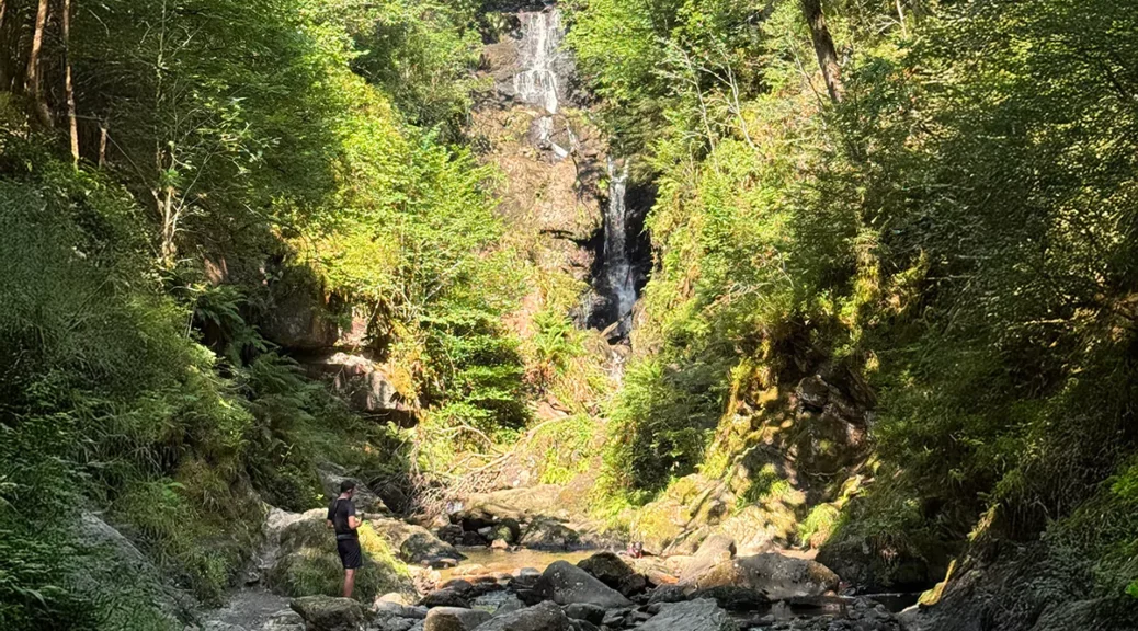
All posts by Glenda A. White

Saturday, 8th March: A Milngavie Meander

This meandering walk will take in sections of Mugdock Country Park, Milngavie Reservoir and the West Highland Way. There will be options to shorten the walk.

Situated 10 miles north of Glasgow and designated in 1987, the 270 hectare Mugdock Country Park comprises woodland, moorland and heathland. A good proportion of the park is designated as a Site of Special Scientific Interest (SSSI).

There are many interesting parts to the park including Mugdock Loch, Craigend Castle, Mugdock Castle (a Scheduled Ancient Monument), and an anti-aircraft gun site (from WWII) at Khyber Field.

The Courtyard, adjacent to the parking area, houses the Visitor Centre, shop, toilets, and café.

Saturday, 8th February 2025: The murals of Glasgow

Anyone who is familiar with the City of Glasgow will know that there are a number of murals which have been added to buildings over the past years. Some have remained unchanged from year to year, and others have periodically changed. This walk is a tour round Glasgow city streets looking at some of its fantastic array of street murals.

Stage 1

The walk starts on West George Street and then continues through George Square into George Street. There are several murals on the walls of Strathclyde University. The first gable wall showing a lecture and the street frontage incorporating the University’s most celebrated people. Further down the road the ‘Wonderwall’ continues with murals including ‘Dansken Equatorial Telescope’. At the end of the block, the final gable depicts the ‘Land Ship’ which was a mock-up navigation bridge once used to teach at the school of Navigation. All these murals were made by Art Pistol, aided by Rogue-One and Ejek. Continue along George Steet to the junction with High Street. On the gable wall just before the junction is a stunning mural by Smug of ‘St Enoch’ (a woman cradling a child, Kentigern [St Mungo], the patron saint of Glasgow). From here, make a detour to the left up High Street until the gable wall at the opposite end of the terrace of buildings on the left. Here is another Smug mural, ‘St Mungo,’ (a man with birds). From here turn around and walk back down High Street, ignoring the junction with George Street, and taking a right turn into Ingram Street. Look out for a plaque marking the birthplace of William Motherwell a renowned Glasgow Poet.

Stage 2

After the first block in Ingram Street, there is a car park on the left side; the wall enclosing this has a huge mural entitled ‘Fellow Glasgow Residents’ (also created by Smug) which depicts the varied wildlife of Glasgow’s parks. It takes some time to take in all of this one! At the far end of the mural turn left into Candleriggs to enter the Merchant City. This was once the bustling commercial heart of the city but fell into decline before being regenerated in recent decades. It is now packed with restaurants and bars.

Stage 3

After the first block in Candleriggs, turn right into Wilson Street and walk down the rainbow pavement. On a gable wall there is ‘Bow Down, Honour Thy Routes’ – a mural by Indian artist Shilo Shiv Suleman created as part of COP26 which was held in Glasgow. Returning to Candleriggs, turn right and at Trongate turn left. Pass the impressive clock tower (Tollbooth Steeple) and continue ahead (crossing High Street) into Gallowgate with the Merkat Cross to the right. Continue along Gallowgate until the junction with Moir Street. Turn around to see the first Billy Connelly mural on a gable end. Continue along Gallowgate for a passing look at the famous Barrowland Ballroom (The Barras)! Turn around and return to Moir Street and enter Barrowland Park. Cross the park using the Album Pathway (which was created by Jim Lambie) and on exiting the park turn left to rejoin Gallowgate and head back to the Tollbooth Steeple.

At Saltmarket, turn left and pass under the railway bridge. Then take the first left into St Andrew’s Street to see ‘The Fish Plaice’ mural. Across from this mural is another one called ‘Study of a Women in Black’. Continue around St Andrew’s Square taking in the architecture of the former St Andrew’s Parish Church. Return to the railway bridge in Saltmarket and cross over into Osborne Street. Then turn right into King Street and then left into Trongate. At New Wynd, turn left to view the colourful ‘Spaceman’ (on the right) and pass the Britannia Panopticon Music Hall. Stan Laurel made his debut here in 1906. Emerging from the south end of New Wynd, John Byrne’s mural of Billy Connelly can be seen to the right. There is also one of Thomas Muir a Scottish Political Reformer and lawyer.

Stage 4

Return to the Trongate, via New Wynd, and turn right. Take the right fork of Trongate and then turn right into Saltmarket. Continue south down Saltmarket, passing under the railway bridge, and at Bridgegate turn right to find another ‘Study of a Women in Black’. Reaching the busy junction near the river there is a series of murals on the wall of the Clutha. A short detour round the end of the building (to the left) reveals a mural of Charles Rennie Mackintosh. Continue the walk by crossing Clyde Street and turning right onto the Clyde Walkway. Passing the Metropolitan Cathedral of St Andrew, stop to see the Italian Garden and Arandora Star Memorial. The latter, a memorial to all those men who died on the ship SS Arandora Star which was sunk by a U-boat in 1940. After passing under a pedestrian suspension bridge leave the Clyde Walkway and rejoin Clyde Street. Cross the road at the pedestrian crossing and head up Dixon Street. On the right is a third mural of Billy Connolly, this one based on a work by Jack Vettriano.

Stage 5

Continue up Dixon Street and continue through St Enoch Square. At Argyle Street, turn right and then take a left turn into a narrow, covered alley (Cranston House) to see ‘Are Ye Dancin?’ by Conzo and Globel. The murals are on both walls of the alley – an amusing take on Scottish icons. Return to Argyll Street and turn right and at Buchanan Street turn right again. In Springfield Court – off on the right – there is ‘Good as Gold’, a humorous take on inflation and Freddo prices! Returning to Buchanan Street, head up to the Gallery of Modern Art (GoMA) in Royal Exchange Square to see another ‘Study of a Woman in Black’ on a lane wall.

Stage 6

Head back down Buchanan Street and turn right into Mitchell Lane and then left into Mitchell Street. There are several murals along here. The first is on the right and called ‘Wind Power’. Continuing down Mitchell Street look back to see Smug’s massive ‘Honey I Shrunk the Kids’ on a gable wall. Finally, on the right is ‘the World’s Most Economical Taxi’ by Rogue-One. Look closely – that is not really a brick wall!

Stage 7

Turnaround and go north up Mitchell Street and then left into Gordon Street. Next, turn right into Renfield Street and left into Renfield Lane – passing Rogue’s spectacular ‘Bubbles’. Take the next left down Hope Street, which later becomes Oswald Street. Turn left into Midland Street to see ‘Portrait Gallery’ by James Klinge. Returning to Oswald Street, turn left and continue down towards the River Clyde. Cross Broomielaw and turn right once more onto the Clyde Walkway. Approaching the M8 Bridge, rejoin the pavement beside Broomielaw and pass under the M8.

Stage 8

Use the pelican crossing, cross to the north side of Broomielaw. Note the electricity substation building on the right which is covered on two sides by a Smug mural ‘Generation Green’ celebrating the growth of green power. Walk north towards the Mitchell library and then turn right into Sauchiehhall Street. At the iconic Beresford, turn right into Elmbank Street. At the corner of Sauchiehall Lane (on the left) is one of the ‘Lost Giant’ murals by Australian artist Stormie Mills. This is one of a series placed in cities around the world. Return to Sauchiehall Street, and turn right. Continue along Sauchiehall Street and at Hope Street turn right. Then take the first right into Sauchiehall Lane. Here is the final mural of the walk, ‘The Musician’, by Rogue One in collaboration with Art Pistol.

Meandering the Leven

Starting Point for the Walk:

Dalreoch Station car park – OS Reference NS 391 756.

Getting there: 13 miles/36 minutesv

Take the A82 out of Glasgow to the West.  Pass the Erskine Bridge and descend to a major roundabout at Bowling.  After a short distance, at traffic lights, turn left onto the A814 towards Dumbarton and Helensburgh.  Follow the road through Dumbarton and follow the signs to Helensburgh.  After crossing the River Leven, in Dumbarton, turn right into Dalreoch Station Car Park.  Parking is free.  There are regular train services to and from Glasgow.

The Walk:  Dalreoch to Balloch – 7.0 miles (11 km)

Exit the car park at Dalreoch Station onto the riverside path and turn right to go South.  At Bridge Street, cross over the road into Woodyard Road and then enter Levengrove Park at the corner of Levenford Terrace.  The park sits at the junction between the point where the River Leven meets the River Clyde and tea and coffee are available from an attractive shop in the park.  Exit the park to the North (retracing the outward route from Dalreoch Station) and then follow an excellent riverside walk along the River Leven.  The river has two unusual loops at Dalquhurn Point and Cordale Point.  A grassy path on each loop deviates from the main tarmac path for a closer walk by the river.  Rejoining the main path each time, the route passes Renton, Vale of Leven, Alexandria, Dalmonach, and Jamestown before reaching Balloch.

Take the train from Balloch Station to Dalreoch Station to return to the Starting Point.

Annbank & Auchincruive

This circular winter walk takes us to the old mining village of Annbank in Ayrshire. The walk starts from the village bowling green and heads north to Brockle Wood before entering the Auchincruive Estate and heading to the River Garden. After looping through the estate, we pass Auchincruive House (designed for the Oswald family by Robert Adam around 1764 but substantially modified before being built) before descending to join the River Ayr for a pleasant return walk to Annbank and the starting point.

Starting Point for the Walk:

In Brocklehill Avenue, Annbank, Ayrshire.  Park adjacent to the Annbank Bowling Club – OS Reference NS 407 233.  Alternatively, park on Weston Avenue.

Getting there: 36 miles/50 minutes

Take your favourite route out of Glasgow to join the M8 (south) and exit onto M77 (Kilmarnock).  At Fenwick continue onto A77 until the roundabout at Sandyford Toll.  Take the 1st exit onto A719 but continue onto B742 (Mossblown).  At the off-set crossroads in Mossblown cross the B743 and continue on the B742 (Annbank).  After a sweeping lefthand bend and just before the railway bridge, turn right into Annbank (B744).  Continue for a few hundred metres and turn right into Brocklehill Avenue.

The Walk:  Annbank to Auchincruive Circular – 4.4 miles (7 km)

Head in a north westerly direction from Annbank Bowling Club taking a small path at the end of Brocklehill Avenue.  The path leads downhill through woodland and into Brockle Wood.  Bear right where a track and path meet and at a junction of paths turn left into Brockle Wood.  Then follow the path by the stream to the left and follow this pleasant route through woodland.  Continue on this path, veering away from the stream by ignoring a path to the left.  After a short distance take another path to the left that descends to the River Ayr below.  At the bottom, pass through a stone wall into the Auchincruive Estate.  Continue along this often-muddy path until the River Garden.  Turn right through a gate and head for The Bothy Café where there are toilet facilities.

Head west from the café and exit the River Garden through a walled gateway.  Take this hedged broad pathway past the croquet lawn which overlooks the rear of Auchincruive House (previously known as Oswald Hall).  At the crossing of paths continue straight ahead and follow a grassy path past an expanse of water on the right.  The path passes near an area of estate buildings and Oswald’s Temple before joining the main roadway into the Estate from the north.  Turn left and follow this roadway down past the front of Auchincruive House continuing down the old drive until reaching the locked gates close to Oswald’s Bridge.  Go through a pedestrian gate on the left and turn left onto the riverside path.  Keeping the River Ayr on the right, continue along the path until the River Garden.  Turn left, and instead of heading for the Bothy Café, turn right and at the edge of the garden, pass a house before exiting onto a driveway and turning right.  Go through the gate on the left and follow the rising path through woodland.  Keep to the rising path and ignore paths coming in from the left.  Continue on this path until it joins a track coming in from the left.  Turn right and after passing the descending path on the right (that was used on the outward route) bear left into woodland (a blue arrow sign indicating the way) and retrace the outward route back to the cars.

On the Canal

Our walk in this month takes us back to old haunts and, given a lovely day, is one of the most attractive we have ever done.

Meeting at Muiravonside Parish Church on the Forth and Clyde Canal we join the canal and turn west to the basin on Bethankie Bridge (which is a tunnel not a bridge!). Here we board a canal boat, cross the spectacular Avon Aqueduct, and go west to Linlithgow canal basin. A short walk takes us down to the centre of Linlithgow.

Those wanting a longer walk will go round Linlithgow Loch and back to the Canal via the River Avon. Those wanting a shorter walk can find lunch in Linlithgow and then rejoin the canal for the walk back to Muiravonside. This is one of the finest walks in central Scotland. Do join us!

Bridge of Allan/Dunblane

This circular walk, of approximately 7 miles, links the towns of Bridge of Allan and Dunblane. The walk initially follows the Allan Water starting at the west side of Bridge of Allan and follows along the Darn Road (an old drove road). It continues as a path between drystane dykes, passes fields, a golf course and Kippencross House before entering the town of Dunblane. The route returns along Glen Road crossing the Wharry Bridge and dropping back into Bridge of Allan and the starting point.

Starting Point for the Walk:

Blairforkie Drive in Bridge of Allan (just off the roundabout on Henderson Street).   There is plenty of free parking available on Blairforkie Drive – OS Reference NS 788 978.

Getting there: 34 miles/50 minutes

Take your favourite route to the M8 (Edinburgh) and then onto the M80 (Stirling).  Then continue onto the M9 and exit at Junction 11 (the end of the M9).  At this roundabout, take the 4th exit onto the A9 (Bridge of Allan) heading south.  Enter Bridge of Allan on Henderson Street, pass the Bridge of Allan railway station, cross the bridge over the Allan Water and immediately turn left into Blairforkie Drive and park at a convenient location.

The Walk:  Bridge of Allan/Dunblane Loop – 7.0 miles (11 km)

Starting from the foot of Blairforkie Drive, go up the road and after about 400 yards turn left where the start of the ‘Darn Road’ is signed.  Follow this as it runs above the Allan Water then bear right into a gorge carrying a burn.  Cross carefully by stones and a footbridge before continuing uphill to the right.  The track eventually continues as a sunken path between drystane dykes, past fields and skirts past Dunblane Golf Course and close to Kippencross House.  Halfway along the sunken path, alongside a golf fairway, the path veers left – follow it to a main road on the edge of Dunblane.  Continue into Dunblane and along by the Allan Water towards the cathedral.  There are benches  for a lunch or rest.

After lunch, walk back to the main road and turn left up to the roundabout and follow the Glen Road signed for Sheriffmuir.  After a mile, ignore the sign for Sheriffmuir, and carry straight on down a single-track road.  This becomes traffic free after about half a mile.  Continue on the Glen Road and cross the Wharry Bridge, eventually dropping into Bridge of Allan.  Pass through Sunnylaw, and after approximately 500 yards, turn right into Blairforkie Drive to return to the starting point.

Bar Hill & Antonine Wall

This walk traces the Antonine Wall, an old stone and turf rampart, that was once the northern boundary of the Roman Empire. It was built about 142 AD on the orders of Emperor Antoninus Pius. It stretched 60km from Bo’ness in the east to Old Kilpatrick in the west.

The route passes the remains of a fort and bathhouse on Bar Hill, where a large collection of coins was found when the site was excavated, suggesting it was also something of a gambling den.

The route continues through woodland to Croy Hill before a meandering return along one of the most scenic stretches of the Forth & Clyde Canal.

Starting Point for the Walk:

The car park opposite The Boat House at Auchinstarry Marina, Kilsyth (G65 9SG) – OS Reference NS 721 767.  Parking is free.  Toilets available in the hotel.

Getting there: 16 miles/30 minutes

Take your favourite route to the M80.  Exit at Junction 4A, using the left-hand lane to exit towards Kirkintilloch/Kilsyth/B8048.  Keep left and follow signs for Kirkintilloch/Kilsyth/B8048/B802.  At Back O’ Hill Roundabout, take the 2nd exit onto B8048.  At the next roundabout (Craiglinn) take the 3rd exit (continuing on B8048) and at the next roundabout (Blackwood) take the 3rd exit onto B802 signed Croy/Kilsyth.  Stay on this road for about 1.5 miles.  At the next roundabout take the 3rd exit for Auchinstarry Marina.  Park on the right, opposite The Boat House.

The Walk:  Bar Hill and Antonine Wall – 6.6 miles (11 km)  (Shorter options available)

Starting at The Boat House, follow the path in a northerly direction, cross the canal via the road bridge, and turn left through the black and white barrier to pick up the canal towpath.  This gives a pleasant tree lined walk for 2 miles to Twechar.  On reaching the village turn left over the road bridge (over the canal) into Main Street and follow the John Muir Way (JMW).  At an Historic Scotland sign on the left (near the Barrhill Tavern), turn left up a rough farm track which leads to the Bar Hill Fort.  The track rises gently for 1km, giving good views down to the Forth & Clyde Canal and the Kilsyth Hills.


At an old disused reservoir on the right, turn left through a gate on the left and follow the path gently uphill.  The remains of the Roman Fort and Bathhouse are over the brow of the hill.  Looking down the hill at its commanding views, the Antonine Wall lies about 60 metres away.  This was the northern frontier of the Roman Empire for around 20 years before the legion retreated south.  Artefacts from the fort and the wall can be seen in the Glasgow University Hunterian Museum.


From the fort, continue on a steep track that leads to a small Iron Age fort and trig point on Castle Hill.  Again, there are great views over the valley to the Campsie Fells.  Next, continue eastwards on a descending path along the line of the Antonine Wall picking up a track which goes through gates to join the main Auchinstarry to Croy Road*1.  Cross the road and through a gate (continuing on the JMW), then through a field to a small substation.  Next, turn right through a green metal gate*2 and follow the signs, on the left, to Croy.  The path leads eastwards passing houses on the right.  Next, climb Croy Hill and enjoy views over the valley, the Kilsyth Hills and the Campsie Fells.  Further on, take the central track that goes between the two mini peaks and carry on along the path until the Roman Centurian Statue.  Then take the path to the right that leads downhill to the canal.  Cross the canal and leave the JMW by turning left (westward) onto the towpath leading back to Auchinstarry.


Those wanting a shorter walk, can either turn left at the Auchinstarry to Croy road*1 and descend via the road to Auchinstarry (4 miles) or take the track back to Auchinstarry*2 on a less direct route (4.6 miles) .

Falls of Clyde

Starting Point for the Walk:

On the road below the church on Braxfield Row/New Lanark Road – OS Reference NS 880 426.

Getting there: 32 miles / 59 minutes

Take your favourite route to the M74 towards Carlisle.  Exit the M74 at Junction 7 (Lanark/Larkhall) and turn left onto the A72 (brown signed New Lanark).  At the roundabout just before Garrion Bridge go left and at the Garrion Bridges Roundabout take the 3rd exit onto the A72 (Lanark) and continue through Rosebank, Crossford, and Kirkfieldbank.  Enter Lanark from the north side and, at the traffic lights, turn right to join the A73/A473 (brown signed New Lanark).  Continue through the town and past the train station.  At the roundabout take the 3rd exit (Hyndford Road) towards New Lanark.  Take a very sharp left turn into Braxfield Road (then onto New Lanark Road) and follow the signs to New Lanark.  On approaching the main car park for New Lanark turn right to zig-zag down to New Lanark.  Park on the street.  If there is no parking available return to the main car park (fee payable) and walk down to the village.  There are toilets and a café at the Visitor Centre.

The Walk:  Falls of Clyde Circular – 7 miles (11 km)Occasional steep inclines/declines and steps

Staring from the old church, walk up the main road (New Lanark Road) and just before the road swings sharply to the right, turn left onto the signed Clyde Walkway.  Follow this woodland path downwards to the River Clyde and continue past Braxfield Park.  At the steep zig-zag path which climbs to the right, leave the views of the river and emerge into Castlebank Park.  Turn left onto the metalled park road and at the entrance to the park turn left onto St Patrick’s Road.  Follow this minor road to the end and turn left onto Chisholme Brae which passes the water works and meets the river again.

Continue onwards and after passing a few buildings turn left and cross the old bridge (Riverside Road).  Then turn left again into Kirkfield Road.  With the road rising gently, turn left through an old stone gateway onto a woodland track.  Follow this gently rising track watching out for wildlife and spectacular views of the river and falls.  The area is part of the Falls of Clyde Nature Reserve.  Continue past the ruins of Corra Castle and some minor falls and at Bonnington Linn cross the bridge to the east side of the river and turn left.  Continue on this gently descending path towards Corra Linn and the Falls of Clyde.  Pause at the viewing area for the Falls and then continue on the path down past the Bonnington hydro-electric power station at Corehouse.  Just past the power station bare left towards the river and continue onto a short stretch of boardwalk.  The path then continues towards the village and then passes The Mechanic’s Workshop, Robert Owen’s School, the site of Mill 4, the Institute for the Formation of Character, and Mill 3 (the New Lanark Visitor Centre and Café).  Return to the cars parked on the street or at the main car park.