Category Archives: Uncategorized

Aberfoyle: Lang Crags

Mixed woodland autumn colours on the shore of Loch Ard

Starting Point for the Walk:

Western end of the large car park near The Forth Inn in Aberfoyle – OS Reference NN 521 009.

Getting there: 25 miles / 48 minutes

Take your favourite route out of Glasgow to Strathblane on the A81 (or towards Carbeth on the A809 and turn right onto the B834 and then left to join the A81 towards Aberfoyle).  At the roundabout (by the Rob Roy Hotel) on the outskirts of Aberfoyle, turn left onto the A821.  In Aberfoyle, turn left at the sign “Parking/Scottish Wool Centre”.  Then turn right into the west section of the car park and use the parking bays near The Forth Inn.  Parking is free and there are toilets nearby.

The Walk:  Two Options …

Option 1 – Limes Craig Loop – 6 miles (10 km) – Relatively hilly

The walk starts at the car park and heads east past the Scottish Wool Centre and picks up the Rob Roy Way.  Cross the A821 and take the Rob Roy Way past the Dounans Centre.  As the path/Land Rover Track (LRT) enters the wooded area1, turn right.  Continue along the LRT in a nominally easterly direction for about a mile.  The next mile or so gently climbs up the southern slopes of Lime Craig.  Take it at a gentle pace.  The climb commences with a sharp left turn onto another a LRT.  Then take a right turn onto a footpath and continue the ascent of Lime Craig heading in a nominally northerly direction.  Just below the top of Lime Craig, turn sharp left to reach the summit.  Then retrace the route for 0.1 mile and then turn left.  This leads onto a relatively steep and rough path that descends the north side of Lime Craig.  Take extra care here.  Next, join the LRT and follow it in a nominally westerly direction for 0.5 mile (gently loosing height) before it turns sharp right.  At the LRT ‘crossroads’, turn sharp left and gradually loose some more height; after 0.25 mile get great views toward a waterfall (which may look familiar to those who were on the October 2023 walk).  After a further 0.25 mile of gentle descent, turn right onto another LRT and follow it in a nominally south westerly direction for 0.25 mile.  Then cross a footbridge over the Allt a’ Mhangam burn2 and follow a meandering footpath that soon climbs (in a short and steep manner) up to The Lodge Forest Visitor Centre.  Just west of The Lodge Forest Visitor Centre, pick up the “green marker” footpath for about 0.5 mile.  Then take a sharp right turn onto a shared ‘footpath/cycle path’ and descend for 0.25 mile – this leads onto a very short section of road.  Extra  care is required here.  Then follow a road-side footpath and arrive back in Aberfoyle.


Option 2 – David Marshall Loop – 3 miles ( 5 km) – Limited hills

This walk starts as for Option 1 but as the path/LRT enters the wooded area1, turn sharp left.  Follow the “red marker” LRT in a nominally westerly direction for about 0.75 mile.  At the footbridge over the Allt a’ Mhangam burn2 follow the route for Option 1.

Burncrooks Reservoir

This walk is similar to a circular “summer” route traversed about 8 years ago. The main difference is that this time we will cover the route in an ‘anti-clockwise’ direction – and being in the “spring”, the walk should look sufficiently different from the previous version!

Starting from Edenmill Farm Shop (near Carbeth), we join the John Muir Way and follow it in a westerly direction for about 4 miles. In due course the path climbs through Forestry Commission land which eventually leads to Burncrooks Reservoir. The path around the Reservoir has plenty of good views – weather permitting! After traversing the Reservoir, we follow a forest road in an easterly direction which eventually brings us back to Edenmill Farm Shop.

A Canal, A River and A Park

The walk starts by going into Westerlands Estate by the old cinema at Anniesland and continuing through it until it reaches a small roundabout. Then follow the rough path to the left through a small, wooded area to reach Strathcona Gardens, then turn right onto a small path, then go left at a fork leading to the Forth & Clyde Canal.

Walk along canal passing Lock 27 and continue to Netherton. Cross the canal at the lock and turn right along the north bank of the canal. Go under two railway bridges to reach Islay Avenue then on to Bearsden Road. Turn left and opposite the entry to Garscube Estate take the pathway into Cairnhill Woods. The Woodland trust have been involved with these woods and there are some intriguing wooden sculptures to be seen along the pathways.

Continue through the woods, cross Henderland Road, and continue into the second section of woods, through a loop route and then back to Bearsden Road.

Carefully cross Bearsden Road (dual carriageway) and enter Garscube Estate (Glasgow University Vet School) and

proceed gently downhill until an open area. We may have lunch here. Cross the rustic stone bridge over the River

Kelvin and then follow the bank of the Kelvin and onto a path which leads out onto the Dalsholm Road. Turn right,

then right again and continue onto the (Old) Dalsholm Road. This old road crosses back over the Kelvin and then continues uphill. Before reaching the metalled section of Dalsholm Road, just before the entry to the recycling plant, turn right towards Dawsholm Park.

Cutting across the fields enter Dawsholm Park and proceed up the main avenue. Before reaching the main gate turn back left to follow the edge of the park eastwards. At the end of this peripheral path turn right and proceed downhill to reach Dalsholm Road again. Turn right and continue down the road crossing two railway bridges. At the small roundabout turn right, and after crossing the canal, turn right onto the canal towpath. Continue to the point just beyond the gas-holders and take the left track which continues into Strathcona Gardens. Turn left and cross therailway bridge to the Westerlands Estate. Retrace the outward route to return to the original starting point in Ascot Gate.

Circumnavigation

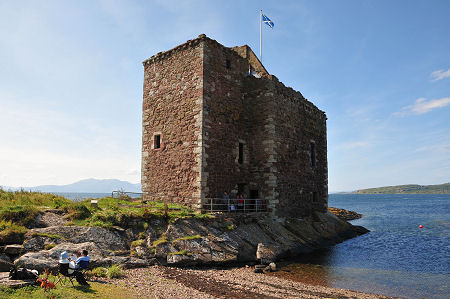
This circular summer walk around Loch Leven takes in many beautiful spots including varied woods and marshland.  It is particularly renowned for its birdlife.  There are several opportunities for caféstops along the way! The ruined Loch Leven Castle sits on a small island in the loch and can be visited by ferry (from Kinross pier) in the summer.  Mary, Queen of Scots was imprisoned here in 1567.  The largest island, St Serf’s, has the remains of an Augustinian Priory founded in 1150.Loch Leven is a National Nature Reserve and the route skirts the RSPB Loch Leven Reserve which sits on its southern shore.  Ospreys fish in the loch in the summer and there are also red squirrels.

Starting Point:

The starting point is at OS Reference NO 125 019 which is the parking area, near the toilet, at Kirkgate, Kinross (see map >).  

Getting there: 47 miles/60 minutes

Take your favourite route out of Glasgow to M8 (Edinburgh) and exit at Jct 13 onto M80 towards Stirling.  Continue on M80 until Jct 8 where the road splits – keep to the left and continue onto M876 (signed Kincardine Bridge).  Continue on M876 and merge onto M9 for a short distance leaving at Jct 7 back onto M876 (Kincardine Bridge).  At the roundabout take the second exit (A876) and cross the Firth of Forth.  At the Kilbagie Roundabout turn left (A977) and at the Gartarry Roundabout take 3rd exit and stay on A977.  Continue on A977 and at the roundabout on the outskirts of Kinross go straight on (2nd exit) onto A922.  Note the tourist sign for Loch Leven Heritage Trail.  At the next roundabout go straight on (Kinross).  This is now Station Road (B918).  Go straight on at small mini-roundabout and at the end of the road go right at the large mini-roundabout into High Street (B996).  Continue down this cobbled street and take the 3rd left (after passing the hotel) into Burns-Begg Street (signed Kirkgate Park).  Take second turning on left into Kirkgate (signed Kirkgate Park).  Continue along this narrow one lane road into the park and head for the second parking area opposite the toilet (20p).  Parking is free.

The Walk:  Loch Leven Heritage Trail – 10.0 miles (shorter if the small hill detour is omitted)

The walk is level, except for the detour, and follows the Heritage Trail in a counterclockwise direction from the Kirkgate car park towards the Boathouse and a cashmere factory.  The path continues and winds through fields with the loch on the left and views of Castle Island.  Although the path veers away from the loch side the next section is popular with nesting sand martins and in the spring and summer the fields are often busy with lapwings, oyster- catchers and other birds.  

Continue onwards along the path for just less than 4 miles until a covered viewing area is reached.  This is slightly raised and may be a suitable place for lunch before arriving at the RSPB Visitor Centre at Vane Farm.  Here the RSPB has set up an excellent viewing area upstairs with telescopes, enthusiastic staff, and a café- this is free.  However, if you wish to enter the reserve and visit the hides there is an entrance fee (unless you are an RSPB member).  You can have coffee here and stay to enjoy the sights.

RSPB Visitor Centre Amenities

Viewing screen past picnic area allows close-up views of birds using feeders.  

Indoor viewing area in café.  Telescopes, including one adjustable, overlook Loch Leven.  

Three hides on Wetland Trail.  Live birdfeeder camera action shown on large screen in café.  

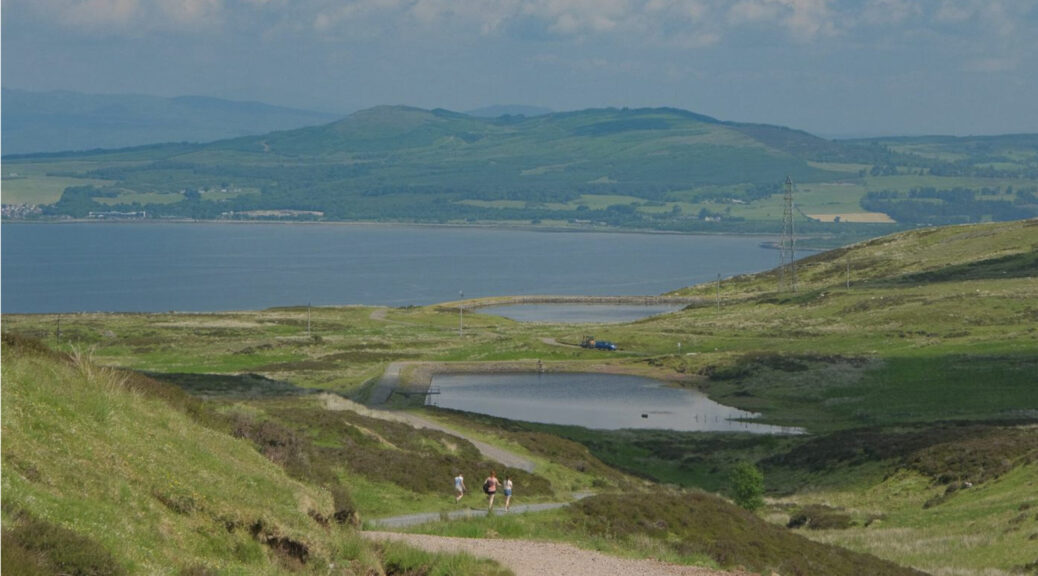
Those wanting a elevated view over Loch Leven can continue on the Woodland Trail (1 mile) which leads through birch woods to a viewpoint at the top of Vane Hill (248m) and then back to the Visitor Centre.  From the RSPB Visitor Centre retrace your steps along the Heritage Trail to the Boathouse and then to the parking area at Kirkgate.

Those wanting a much shorter route can stop at the Boathouse and get a ferry to Castle Island and visit Lochleven Castle which has an interesting history.  The ferry (maximum 12 people per trip) is weather dependent.  There is an entrance fee but it is free to Historic Environment Scotland members.  Booking is recommended. 

Alternatively, another walk option is a circular signed walk (3 miles) going clockwise from the parking area.

Walking at lambing time

It is probably best NOT to walk at lambing time but occasionally you might  unexpectedly come across the sweetest little bundles of wool with pink ears and knobbly legs you’ll ever encounter!! From April to early June some ewes may even be in lamb.  Despite their appeal, however, they are other people’s livelihood.

PLEASE do not go near the lambs, for example to take photographs. Never touch them – you will leave human scent on them and the ewe will abandon them. Don’t come between the ewe and her lamb for the same reason – the wind will carry your scent on to the lamb. Don’t stop to watch for too long – the wind is blowing! Leave the shepherd and the ewe to sort out any apparent problems, for example being stuck on wire or in apparently dangerous places.  You can only make matters worse and, surprisingly enough, shepherds are quite good with sheep! It is very unlikely that a lamb is dead – and if so, the shepherd will pick it up.  Don’t speak to the ewe – even to mimic a baaing sound – unknown human voices are distressing.  Please give ewes and lambs time to get ahead and off the track before coming close.  Always wait for the lamb to find it’s mother – if the lamb doesn’t follow immediately, the ewe will come back for it.  And please close gates if the next group is some distance behind. Each group will have to open and close the gates for themselves.  And don’t have lamb chops for lunch!!!

We are very grateful to all those who make their living in the countryside. Whatever the law says, we shouldn’t abuse their good will.