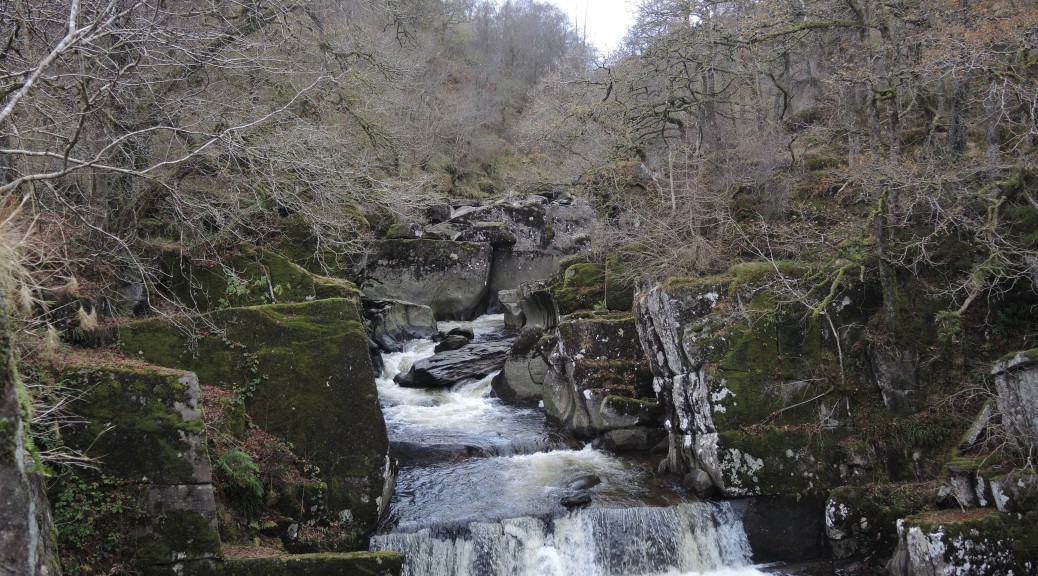
All posts by Glenda A. White

The Bracklinn Falls from the River Leny

The first part of this walk is by far the prettiest but the second part stretches the legs and offers variety. You set off on a very lovely path along the River Leny. After the river walk and the railway track there’s a long gentle climb up to the Falls. Thereafter there’s a lovely woodland walk back down into Callander. The Longer route takes you across the meadows to Kilmahog and then climbs a little befoe returning through Coilihan Woods. The walk is as flat as you’ll get in the countryside – but oh so beautiful and with wonderful views. The Tourist Centre will have maps with walks around Callander which match the coloured posts en route.

Callander, Stirling FK17, UK

Park in Callander. As this is a circular walk it doesn’t matter where on the route you park, but there is a charge in each of the two main car parks (down by the River Leny and behind the Dreadnought Hotel). Outwith the height of the tourist season here is ample free parking in Callander: round Callander Kirk, along the Main Street out towards the Roman Camp Hotel, and up and along the disused railway line, for example at Glenartney Road. You could also start at Kilmahog. Just check that wherever you park there there isn’t a time limit.

To get there take your favourite route to Aberfoyle (generally the A81 which you pick up either at Maryhill Road or Canniesburn Toll). The A81 takes you through the east end of Milngavie (past what was the East Dunbartonshire Council Buildings and is about to be a Hotel); round the roundabout at Homebase, etc (sign-posted to Strathblane); past the waterworks; on to Strathblane, Dumgoyne, Gartmore House to the roundabout outside Aberfoyle where you turn right to Callander, still on the A81. Drive past Braeval and the cottages at Lake of Menteith turning sharp left with the A81 and following the signposts to Callander. At the mini-roundabout, just past the McLaren High School and Leisure Centre, turn right to go up the hill into Callander, and right or left at the traffic lights depending on where you’re parking.

The Walk

Since the first part of the walk is the prettiest, you may like to begin the walk by continuing along the Main Street and past the junction for the road up to the Bracklinn Falls on the left and the Roman Camp Hotel on the right. A sign post directs you down a narrow path (blue dots on the map) which soon opens out, undulates along a low ridge between the town houses and the river and then makes down to the river. The stretch along the river is lovely. Pass an information board and platform for fishermen, and continue to where the path is forced inland (just over a planked deep stream) up a set of steps, across a field and on to the main road at a bus stop. There are pedestrian traffic lights to allow you to continue across the road and up a track on to the old railway line. At the junction with the railway line, turn right (white markers on the map).

The next part is very easy walking and very beautiful. Continue with the track past Auchenlaich House (ignore both the path parked ‘Private on the left and the Keltie Bridge Caravan Par on your right) and begin to climb gently but steadily. There are glorious views of Callander and Ben Ledi beyond. At the junction (with a notice saying Bracklinn FC to the left) turn right. This soon emerges on the main Bracklinn Falls path (purple dots on the map). However, it is particularly beautiful to go straight on here (instead of turning right to the Falls) on a new path created when the bridge was replaced. This is very short but brings you along the river upstream from the bridge.

After visiting the Falls get back on to the main path (purple dots) either by re-tracing your steps back the way you came down (gentler) or stepping between two boulders on your left and going straight up some steps (steeper). Continue along to the Bracklinn Falls car park. There have been forest operations along the route which, while untidy, have opened up the views. At the country road going up to Braeleny (through a huge gate), turn left downhill. (White dots on a yellow road.) At the blue Parking sign, turn right and at the gate take the lower red-and-brown dotted route through the forest. At a viewpoint with a bench, a post with a red marker goes up hill, but you go left downhill. There are some very slippery boards here! Avoid! This path comes down to Tulipan Crescent.

The Short Cut

If the weather has been dry for a couple of weeks you could turn right, cross the road, go down to the old railway but turn left around the car park (orange dots on the map). Alternatively, turn left in Tulipan Crescent to pick up the railway going in the opposite direction (red dots) and wiggle your way either along Ancaster Road (red dots) or the old railway (blue dots). (To follow the Ancaster Road route, from Tulipan Crescent follow the old railway track through to the car park and from the far, top corner of the car park go up some steps and across the bridge into Ancaster Road, and turn right.) Either way, you reach the Main Street easily.

The Longer Route

For a longer walk, cross the main road (A84) from Tulipan Crescenet and go straight over to the railway line turning right towards the signal. Follow the railway line towards Kilmahog. (Notice the very clear outline of a Roman camp on the right in the meadows as you near Kilmahog.)

At Kilmahog, cross the country road (A821) and take the off-road-path running parallel to the road on the left. Follow this to another car park on the right but go straight on to pick up the Woodlands’ Trust path contouring round the hillside parallel with the road on the left and under Samson’s Stone on the right. This comes down to the A821 opposite the Invertrossachs Road. Cross the A821 and go down the road towards the bridge. Cross the bridge and turn left. Follow the road to a car-park on the left. The main path (green dots) goes up directly in front of you. However, it is shorter and prettier to take the path on the left and follow this to a wee lochan at Callander Holiday Park. Follow the signs through the park to rejoin the Invertrossachs Road. Take the road to the junction with the A81. You can either cross the River Leny on the road here, or turn right at the roundabout, cross the road and take the path on the left to go down to the pedestrian bridge and up South Church Street.

A tale of two ducts (one aqua, one via)!

The centrepiece of this walk is undoubtedly the canal aqueduct at Lin’s Mill where the Union Canal crosses the River Avon. With a little effort it’s possible to view the river below from both sides of the canal without actually getting your feet wet! To get to the aqueduct you follow the canal feeder from the Visitors’ Centre in Almondvale Country Park along a picturesque path through open countryside. At the aqueduct you pick up the Union Canal which takes you to the Brox Burn which, would you believe, is in Broxburn! There’s a short stretch beside a housing estate but after about half a mile the path becomes prettier. You eventually come past Uphall Station (where the walk officially starts) and the next 2 miles on a disused railway line a bit sore on the legs. However, as you re-enter the Country Park the scenery improves and suddenly you’re on the Camps viaduct which carried the mineral railway you’ve been walking along across the River Avon. A beautiful stroll through the autumnal woods of the country park and we’re back to the Visitors’ Centre.

You can do this walk from Uphall Station which gets the boring bit over first. However, parking is easier at Almondvale, it’s a much prettier place to start, and there are toilets and a coffee machine.

Park in Almondvale Country Park

West Lothian, UK

To get there, the postal code for the park is EH52 5PE and works well with the satnav. Otherwise, getting to the park is very simple and should take about 40 minutes from Glasgow. Leave Glasgow on the M8 heading east towards Edinburgh, and stay put for about 30 miles until JUNCTION 3 (not Junction 3A which you come to first) where you leave on the left to take the A899 to Livingston (and West Calder). You swing around the slip road, back over the motorway and come to the roundabout with a whalebone structure in the centre. Take the first exit down the main Livingston dual carriageway but after 800 yards take the road to the left sign-posted Pumpherston and Uphall Stations. (There are a pile of Livingstone estate names – ignore these!). You come down to a main road where you turn left and at the next roundabout also take the first exit on to Houston Road and the Houston Industrial Estate. At the traffic lights, turn right on the B8046 (Pumpherston Road) towards the unprepossessing village of Pumpherston. A few hundred yards on, just before the Bay Leaf Restaurant, there’s a sign on the right pointing to the road on the left: Drumshoreland Road, Pumphertson and Uphall Stations and Almondell and Calderwood Country Parks.


Turn left here, go through a series of chicanes and then travel about a mile along an increasingly countrified road to a junction. There’s a big sign to Broxburn pointing left, but the sign for Almondell and Calderwood Country parks is hidden until you’ve actually turned right! Drive down this single-track country estate road till you come to the North Entrance and turn right and park. I the opposite corner of the car park, by an information board and dog pooh bin, there’s a path which meanders parallel to the main drive way and saves walking on a metalled surface. There are several paths off this to join the driveway.


The walk

From the Visitors Centre, with your back to the centre, turn right and follow the path past the toilets, across the play-park and down to the path along the river. Continue in the same direction to the suspension bridge which you cross giving lovely views of the River Avon. Go up the hill a little but, where the steps continue on up, turn left along an idyllic path beside the canal feeder. The next three miles are very pretty with the little burn running beside you, open countryside on the left and frequent little stone bridges and sluice gates and stuff. At the end you have to climb a steep set of steps to reach a rough track where you turn left.


When you get to the Lin’s Mill aqueduct it’s worth spending some time here so at the junction of paths just before it first go right to reach ‘this’ side of the canal, a turning and berthing basin and views along part of the Union canal which you don’t do! However, you can turn left along the aqueduct with spectacular views of the River Avon and Kirkhill Wood below. Retrace our steps to where the rough track forked but this time take the left–hand path which goes down to the river itself and underneath the aqueduct. The advantage of this is that it avoids a set of steep steps down, but gives very good views of the river and the aqueduct itself. Go under the aqueduct and climb up a set of steps to get to the other side of the aqueduct. If anything, the views are even better but in any case you need to be on the other tow-path.


The John Muir Way Link

This section is the the ‘Link; between The John Muir Way, which finishes/starts at Dunbar and the Southern Upland Way, which finishes/starts at Cockburnspath.  Even if you are not embarking on either of these great ways, this is a wonderful walk in itself. You will need to use local transport or a taxi – or walk it over two days beginning at each end and going half way. Note that you are following the final, unofficial section, of the John Muir Way (JMW). At the time of printing, you won’t find this section in any of the current Guidebooks to, or maps of, The John Muir Way which officially ends/starts at his birthplace in Dunbar. However, very recently it was decided to extend the route to Cockburnspath to join up with The Southern Upland Way (SUW) which wanders through the Borders to Portpatrick. Even the official end of the JMW Link ends in a layby on the A1.! So you follow a local route to Cockburnspath and then the SUW down to Cove. The JMW Link is well sign-posted as such. The SUW short section is the denoted by the traditional Scottish logo for a National Trail – thistle within a hexagon.

 Start either in the Shore Road car-park or at the Leisure Pool (although you’ll miss one of the best bits if you skip the first mile or so! Both car-parks have toilets.


East Lothian, UK

To get to the Shore Road car park go through Dunbar on the A1087 to West Barns (pub on the left) then signs to the Bellhaven Bay Caravan Park.. Turn left down Shore Road and drive to the very end. There is an Information Board, and magnificent views of the John Muir Country Park, Berwick Law and the Bass Rock.

To get to the Leisure Pool continue along the A1087 to Dunbar Leisure Pool, Castle Park, Dunbar EH42 1EU

 Section 1: 1.41 miles.

Your walk begins immediately on a good path just above the shore line and weaves beside the sea between the golf course and the rocky beach below. At the end you step through an archway to a stunning view of the castle. Turn right for the Leisure Pool where there are toilets. and the coach will be waiting.

 Section 2: 5.65 miles. This is a very easy section. It begins just beyond the entrance to the Leisure Pool where a ‘John Muir way Link signpost directs you left, round the castle and down to the picturesque old harbour. The Link (sign-posted) winds its way through the back streets of Dunbar and then out on a path between the seashore and a golf course. You are (continuously) asked to wait until golfers have played their shots, and to speak quietly. Your path follows red posts and you should keep as close to the shore as possible, only joining the golf course road as directed.) At the end of the Links go through Catcraig picnic site and on to Barns Ness picnic site where there are toilets. Then make for the lighthouse, by-passing it eventually by turning right, before following a lovely track, just inland to Skateraw Farm. There are more toilets here.

Section 3: 1.68 miles. Without transport you will have to continue round Skateraw Cove turning left behind the toilets and then climb up a little to by-pass the rocky headland. The path winds down again to the northern side of the Power Station where an obvious promenade, named the Coastal Walk and next to steel gates not through them, goes right around the outside of the Power Station. It emerges at the car-park where a clear John Muir sign-post points left and left again along a metalled road to emerge at Thorntonloch. You are right beside the sea but the concrete is hard going.

Sections 4 and 5: 4.67 miles including the 0.66 miles down to Cove Harbour and back to the coach. This is the most attractive section in that you have a variety of low cliff top, seashore, wooded valleys, farm fields, a picturesque village and eventually drop down to the Smugglers’ Tunnel to Cove harbour.

Start from Thortonloch car-park (toilets) and make your way down to and along the sandy beach to a hidden post taking you a few yards inland and very gently back up on to the low cliffs. (The official route avoids the ‘locals’ path straight up on to the low cliff.) From here you can see ahead to the much grander cliffs of St Abbs’ Head. Now follows a wonderful walk along the tops to Bilsdean Glen. A thickly wooded path takes you right down to the sea. This is the only awkward bit where you have a ⅓ mile walk along a cobbled beach. You may find it easier to walk on the smaller stones by the sea. Then take to the woods again up Dungeness Glen (sign-posted from the beach). At a junction at the top of the glen there is a signpost directing you left to Cove but it follows the road down to the harbour.

Much nicer and safer is to continue up the glen, under the road and rail viaducts, to a country road where you dogleg left and right, up beside some fields, to a signpost pointing you left to the village of Cockburnspath. There’s a Mercat Cross and a Post Office for ice-creams/water and, as you turn left for the last lap, more toilets. At the War Memorial turn left, then first right on a track on what is now the Southern Upland Way. The track leads down under the road and rail viaducts again, straight ahead in front of some cottages, crosses a country road to dogleg along a track through fields and on to the coastal path. Turn left here or you’ll end up in Portpatrick on the Southern Upland Way!!

At the end of this path is a gate with the car-park on the left. Turn right to go through another kissing gate and down a little track to the Smugglers’ Tunnel and out into the little harbour.

Picturesque Pitlochry


This is a lovely varied walk taking in a loch, several rivers, a golf course, a forest track under the hills, winding paths, The Soldier’s Leap at the NT Visitors’ Centre at Killiecrankie, an interesting train journey and a picturesque town! All the paths are good and most of the sign-posting is very clear.

You can either drive to Pitlochry or use the train. The most convenient trains are the 10.01 from Glasgow (Queen Street) to Pitlochry and the 19.06 return

Pitlochry, Perth and Kinross PH16, UK

Begin your walk from the platform you arrive on, walking to the far end of platform and down left on to a track which joins the metalled road (Armoury Road) leading down to the dam and the Salmon Ladder.). You can walk down to the dam to see the river and Ladder and pick up the path on the right going along, but slightly above, Loch Faskally. However, if you’ve done these before, locals have created a short cut from a layby on the right which is slightly easier, quicker and just as pleasant. It soon joins the path along the loch. This is a beautiful stretch.

All too soon, this winding path is blocked by The Green Hotel, and comes up to the road. Go straight across the road (the A924) and immediately turn left and then right over the railway. Use a metalled road to climb a little, past individual houses on either side. At the top, a path is sign-posted to the left going right behind the last house and then through a gate and on to a golf course. Cross to the sign-post in the middle of the gold course, as directed, and then turn right and then left following several Public Rights of Way, usually sign-posted ‘To Craigower’, and always climbing gently, to the house with the red roof (Upper Drumchorry). All this is to avoid the usual (advertised) route which takes a road out of Pitlochry and isn’t so attractive.

At Upper Drumchorry, the path goes left below (south of) the cottage on the and eventually comes out on The Old North Road (with Little Blue Men!). Turn left towards Killiecrankie on a wide, easy LRT which is nearly all downhill. (An optional path to Craigower, which climbs steeply to the viewpoint, goes off to the right.) Further on, at a junction, with a track coming in from the left, go straight on: the sign is hidden on the right in some undergrowth. There are wonderful views where the trees are clear along this road.

The only awkward bit is getting down off this track, but it is very clearly signposted. Turn steeply downhill on the left, under the A9 towering above you, and emerge on the B8079. Here turn right and there is under a mile of pavement walking to bring you to the Visitors’ Centre. There are toilets here, and a small Visitors’ Centre, but the café has closed.

To continue the walk, go along the decking outside the Visitors’ Centre, and follow the wooden steps steeply down towards the River Garry. There is a short path to the right which leads to The Soldier’s Leap, but is also worth taking for the view of railway line! Returning to the main path go right down to the River and follow it (and Little Green Men!) all the way back to Faskally Woods. It is easy to get lost here you should turn right and then left to follow either the Little Green Men or the white posts to the Clunie Footbridge. Don’t cross the river here, but go up the road to The Green Hotel and take the A924 back into Pitlochry.

If you don’t want to do the whole walk, there are ample walks in Pitlochry, all sign-posted with Little Men of varying colours! There’s a leaflet available from the Tourist Centre and many shops.


A convoluted, cobbled-together route around a Pineapple

This is the most level walk you’ll ever do, notwithstanding railway lines and towpaths. With one gentle exception it’s as flat as a pineapple pancake. Note that some of the obvious paths on the map are private, the locals being understandably a bit uptight about irresponsible walkers, so you should stick firmly to public footpaths, even if this does mean a very convoluted route. The well-established woodland drives are beautiful and there are unexpectedly good views of the Ochils across the Forth. Many of the paths take you, depending on the season, between ripening wheat and barley. Dunmore is a well-known conservation village and the pedestrianised centre of Airth has many 17th and 18th century buildings. And then there’s The Pineapple! The area has an interesting history which you might look up on the websites below. The whole walk is nearly ten miles, but it clearly divides into two circles and you can opt out either at The Pineapple if you have a car, or in Airth where there is a fine church, old buildings, two pubs and three coffee shops! If you intend doing this it would be worth printing off some information about both Airth and The Pineapple.

Park at the car-park at the NTS monument ‘The Pineapple’. To get there:

This is the easiest of trips and at about 28 miles should normally take about 35 minutes. Take the M8 from Glasgow towards Edinburgh and then the M80/A80 off to the left, sign-posted Stirling etc. This is an easy and fast run. Follow what is now a motorway towards Stirling/Kincardine Bridge/Perth etc. for about 20 miles. Just past the road to Denny you’ll see the first signpost for the M876 to Kincardine Bridge. Keep in the inside lane and you’ll automatically go off on the M876 (while the middle and outer lanes go on to Stirling and Perth). The A905 is well-sign-posted from the M876 to Airth, Skinflats and Larbert. Go down the slip road to a roundabout and take the left-hand turn (first exit) to Airth. Go through Airth, past the Airth Castle Hotel, to where a brown tourist sign on the right points to the NTS ‘The Pineapple’ on the left. It’s about two miles from the roundabout. Turn left here and then sharp right up a dirt track. Go past a sign for Landmark Trust cottages and then turn right as signed for the car park. There are no toilets at The Pineapple (or anywhere else!) but you are surrounded by woods.


Falkirk, Falkirk FK2, UK

The walk

Begin with a swirl around The Pineapple since that is what you have come to see! From the car-park, take the left-hand path which leads to a pond covered with green moss and apparently full of Great-crested newts which are being scientifically monitored. Already you can see the great Pineapple across the lawns but you’ll soon come out at the Gardens (private/closed) and walk down the main driveway to take photos. Then return to the garden wall, take a path which is little more than a mowing in the lawn and go through a gap in the wall on the left-hand side of the Pineapple. This woodland path takes you left around the Private Gardens and on to a wider forest track where you turn left. At a crossroads of paths continue straight on and to the dirt track you drove up, almost, but not quite, back to the car-park.


Instead of returning to the car-park take the track past the Landmark Trust notice and continue to a sign-post marking a path down to what is called ‘St Andrew’s Drive’ This great track sweeps round the grounds, with lovely views of the River Forth and the Ochils. At an unmarked track to the left it’s worth detouring to find the tower, just about visible through the undergrowth. At a T-junction turn right and go down to a gate across the track and on to the A905. Continue straight on past Dunmore Home Farm (Sutherland Estates) which bends down to the river. It’s worth turning in left here, across a little bridge to sit on the river bank perhaps for lunch. lunch. (You can go all the way to South Alloa but it was tricky and the bus back is only every hour. OK if you time the bus.)


Go back over the little bridge and take the river path to Dunmore, a picturesque conservation village. You ought to do a swirl around here! The path straight south from the village takes you back across the A905 and on to St Andrew’s Drive nearly to the car park. Here endeth the first circle.


The walk continues down the drive and out, for a few yards left, and then right on to the road. Then it cuts in again on a dirt track towards Airth Mains. At a junction turn left down towards the old part of Airth where you can stop to admire the Mercat Cross etc. Continue down to the A905, straight down Shore Road to the river again. Here turn right to take a dubious path along the river bank, which turns right again along a road to the golf course, the A905 and the entrance to Airth Castle Hotel. Take the little path on the left sign-posted to Letham Woods. At the end, turn right, and then right again to come back to the Castle. Go through the main entrance and turn left along a road which soon becomes a dirt track, again with extensive views. You’ll recognise the way back, straight on to the A905 past a prosperous looking Airth Mains Farm, down to the road, turn left, left again and then right up the track to the car park.

Helensburgh to Balloch

This walk covers the first section of the new John Muir Way which opened in 2014 and stretches from Helensburgh to Dunbar, with a new link for 2015 from Dunbar to Cockburnspath to join up with The Southern Upland Way. To do this part in a day, you begin with an attractive walk along the end of Loch Lomond to Balloch Station to take the train to Helensburgh which is fun and has lovely views along the Clyde from Cardross to Helensburgh. It’s a bit of a drag up Sinclair Street, very pleasant around Hill House, flat but endless on the cycle track out of Helensburgh and then OK-ish up through the woods. The deciduous-wooded track is pleasant enough but does seem to go on for ages.

Then all-of-a-sudden it’s beautiful. There’s an optional viewpoint of Loch Lomond with the islands and the Ben as you’ve never seen them – which really is a must. On the other side of the ridge there are views back along the Clyde. However, it’s the Stoneymollen Road, an old coffin route, which makes the whole walk worthwhile. This is an ancient route, quoted in every book of walks in the west of Scotland, to carry the dead from Balloch to consecrated ground in Cardross.  Look for the base of a ‘cross’ stone on the left-hand side at a gate where you begin the descent. The base might also have been used to rest the coffin. The views of Loch Lomond are stunning..

 Park at the Duncan Mills Memorial Slipway car-park in Balloch.

To get there, take the A82 (Great Western Road) through Anniesland, along the Boulevard, by-passing Dunbarton, up the dual carriage-way towards Loch Lomond to the big roundabout looking like a rack of lamb with birds. Turn right here (third exit) for Balloch. At the next roundabout, turn first left for Lomondshores, Balloch Centre, National Park etc. At the next roundabout go straight over to Lomondshores marked by a large slate entrance slab. At the next roundabout, ignore all the invitations to join the red, blue or green car-parks, but go right round the roundabout to take the road to the Maid of the Loch slipway. The road passes Lomondshores (on the left) and is soon designated as the route to the Duncan Mills Slipway. Continue over the next roundabout and turn in RIGHT to the public car park. (The car-park on the left is for trailers, launching boats etc.) Its about 17 miles and should take 35/40 minutes.

There are toilets at the car-park, in the main building. There is also a machine selling crisps and sweets. The café may be open, and if you arrive early the views of Loch Lomond and the Maid of the Loch are lovely. If you arrive late, there may be toilets on the train and definitely at Helensburgh, but not Dalreoch.

United Kingdom

The Train

There’s a suitable train at 10.53 from Balloch to Helensburgh changing at Dalreoch. You should allow 10 minutes to walk to the station and 10 minutes to buy the tickets. The trains are every half-hour so if you miss the 10.53 you don’t have too much of a wait.

The walk

At Helensburgh you emerge from the station following the signs on the right to ‘Hill House’ wiggle past the Co-op (?) and come out on to Sinclair Street where you turn right. The route actually starts at the pier but only the purists will want to go down and back up to find out! Follow Sinclair Street to Helensburgh Upper Station. Here turn left into Upper Colqhoun Street, turn sharp right at the end, with the road. This goes past Hill House (note the Rennie Macintosh lampposts along the verge!). Straight ahead are some woods and signposts which provide a range of options for walkers – The Three Lochs Way, The Helensburgh walkers’ circuit and, of course, the John Muir Way (JM). Follow the John Muir path which is all-too-short and brings you out on to the busy A818. There’s the possibility of walking off-road by the reservoirs just to add variety. Otherwise, cross the road to take advantage of the broad cycle path.

It’s a 1½ mile slog along the cycle path. The views across Glen Fruin towards the Lomond hills improve and towards the end the cycle path moves away from the road. At two JM signs, one for cyclists to go straight on and one for walkers to turn right, go right over a stile by a gate on to a wooded, clear and gently climbing track. It’s OK but there are no views and it does seem endless. However, it suddenly broadens out and you get your first views of the moorland. Astonishingly, there are two sturdy signposts – just as if you were on a real walk in real mountains!!! They point out the Three Lochs Way and the JM way, as well as a route down to Craigendoran!

A little further on is a path to the left going up to a viewpoint over Loch Lomond. This is definitely worth a detour – even on a drizzly day it is magical. You have to come down to return to the main path. Suddenly you’re at the edge of the Kiellator Ridge and a magnificently created, sturdy path going steeply down. The new path brings you out along the old, but upgraded one, with lovely views to the left across the loch.

The central bit of the moorland is a bit bleak where the commercial trees have been harvested. Turn sharp left, rather unexpectedly, to follow a lovely path beside some woods to emerge over-looking Loch Lomond at a gate. Just to the left is the base of a cross stone where the coffins were rested. Pause here and admire the view. Then make your way down the lovely Stoneymollan track to a metalled road. You can take a path to follow the stream down on your right to vary the descent.

Watch for the JM sign to the left to take you over a footbridge across the A82 going up Loch Lomondside. Follow the road to the left from the bottom of the steps and into a little hamlet. At the road turn left, and after 200 yards right, as way-marked, down through Lomond Shores (toilets). Go straight on to the lochside, curving to the left with the path. Then go straight on (ignoring the motor and paddle boats on your left) to the main road you drove in at the beginning of the day. Turn left to, and then straight over, the roundabout to get to the cars.

Kelso to Jedburgh

The total length of your walk is about 13 miles so you might have to organise a taxi, bus or lift! You could also stay overnight in Kelso or Jedburgh and do half of the walk each day. Note that you are following the Border(s) Abbeys Way whose logo is a W with a line underneath. Note the symbol for the St Cuthbert’s Way whose path you share at Dere Street. If you follow this you’ll end up in Lindisfarne! The BAW is circular so make sure you’re going in the direction of Jedburgh or you’ll end up back at Melrose! This is particularly important at the River Tweed in Kelso which you leave for the River Teviot and Jedburgh.

Park in Kelso There is plenty of free parking in Kelso. The handiest car park is The Knowes Car Park, The Butts, Kelso Satnav Postcode: TD5 7BA. The journey is mainly on motorways and dual carriageways with a country road at the end. 

Kelso, Scottish Borders TD5, UK

Section 1: Kelso to Roxburgh 3.68 miles

The first section, starting at the Abbey, is the shortest but involves some road walking out of Kelso along the River Tweed to Junction Pool and down to the River Teviot. There are fine views of Floors Castle and the Abbey on the way. Once beside the river, the walk is easy and pleasant. If you feel you can’t walk too far, this is the section for you. From Kelso Abbey, follow the signs out to the main road, to cross Rennie’s fine bridge over the River Tweed, which has stood here since 1803. Turn right on the A699, pausing to admire the grand classic archway ahead, designed by James Gillespie Graham in 1822 and once the main entrance to the long-demolished Springwood Park House.

Follow the road as it swings left at the point where Teviot and Tweed meet. This is one of the most favoured (and expensive) salmon fishing beats on the Tweed, and is much in demand. Go right with the road, to cross the Teviot by another lovely old bridge, dating from 1795. In a further 250 yards, cross the wall on the left by a stile and go down steps to the riverside path. As the path swings left with the river, the ruins of Roxburgh Castle are seen on the steep slope to the right. This fortress once dominated Roxburgh town, of which no trace now remains. Continue along the riverside path for nearly 1½ miles. You may see mallard, moorhen, mute swan, oystercatcher and heron along this stretch of the river. The path eventually leaves the river to climb a bank and continue along a field edge, giving a good view of Heiton Mill across the river. A stile leads us on to a minor road. Turn left through Roxburgh Mill Farm and continue towards Roxburgh village, with the imposing former railway viaduct an unmistakable marker ahead of you.

 Section 2: Roxburgh to Nisbet 4.47 miles

The second section is very easy walking initially along the River Teviot and then through open countryside along a disused railway line. This flat section, with lovely open views of the countryside, is less varied and a little longer than the first section.

The path goes left, down a lane past a furniture workshop, and back to the river to turn right under a viaduct. Continue along the river bank for about 2 miles. Across the river is Roxburghe Hotel; in its extensive grounds is the championship-standard Roxburghe Golf Course. There are also five sizeable caves in the river bank. One is called the Horse Cave. Legend has it that it was used as a hiding place for Bonnie Prince Charlie’s horses in 1745 while he and his Jacobite army were marching from Kelso to Jedburgh. As you draw level with an island in the river, turn right at the dyke, following the edge of the field uphill to a stile and steps which give access to the old railway line. Turn left and follow the line for just over ½ mile, leaving it down steps to a minor road.

Turn left for a few yards, cross the road and continue up the track as signed. This track soon rejoins the old railway line, which is followed for more than 1½ miles, a flat and easy path, to Nisbet, with the river swinging through a series of broad curves away to your left.

 Section 3: Nisbet to Jedburgh 5 miles

This is the most interesting section although it is slightly longer and involves the only slight incline of the day – walking up the Roman Road of Dere Street. This is a wide, well-made path and doubles with the St Cuthbert’s Way. The final section into Jedburgh has been laid out through pleasant gardens and ends at the Abbey. On reaching the road at Nisbet, you turn left and cross the river. Once across, turn immediately right down some steps to follow the flood bank and then take the riverside for about 800 yards. At a track turn left, then turn right and left, as way-marked, to re-join the old railway line for a final section to Jedfoot, where the Jed Water joins the Teviot. From this stretch there is a fine view across the river to the Waterloo Monument on Penniel Heugh, a noted Borders landmark which can be also reached by a signposted route from the Harestanes Visitor Centre.

A stile leads you out to the A698 road. Cross the road with great care and follow the signs (also now showing St Cuthbert’s Way) to the start of Dere Street, a clear track leading straight uphill. The track is followed for about 800 yards, before you leave it to turn right (St Cuthbert’s Way goes straight on). Go down a path which leads to the access road at Mount Ulston. Follow this road downhill to join another road. Turn left and follow this road down to the A68 (take care again!) to take the riverside path which starts opposite. Follow the path which becomes a road. Where two bridges cross the river, cross the first bridge. Continue keeping left and joining a path that passes through a subway under the road continuing to follow the riverside path. You’ll have a good view of the abbey ahead here. Pass under a subway to the roadside opposite the end of this section, at Jedburgh Abbey.

The Pipe Track

This is a tried and tested route popularly known as ‘the Pipe Track’. It’s a delightful walk, following the route of the pipe (hence its name) bringing clean water from Loch Katrine to Glasgow. The route twists and turns and takes in some very pretty little waterways as well as distant views. The outward route joins up with the West Highland way back. Those not wanting to do the full ten (very flat) miles can opt out at Killearn, have a very civilised coffee in one of the several olde world tea shoppes and bus it back.

PARK in St Kessogs Roman Catholic Church at the War Memorial in Blanefield. (you may wish to leave a donation for the privilege.) To get there from Glasgow take either the A82 (Great Western Road) to Anniesland and then the A739 (the Bearsden/Switch Road); or the A81 (Maryhill Road) both of which take you to Canniesburn Toll. Here, take the A81 towards Milngavie, (not Drymen). Continue on the A81 to the roundabout at Homebase etc. and then continue towards Mugdock, Strathblane and then Blanefield. As you go through Blanefield you’ll pass ‘The Blanefield Inn’ on your right, , and then immediately the War Memorial also on the right. You might get parked here but, if not, turn right into the Campsie Dene Road and then sharp right again up a steep but short road to the car park at the back of St Kessog’s Roman Catholic church. It’s awfy pretty. There is a notice at the bottom saying that walkers are welcome to use the car park from Monday to Saturday.but, The journey, which is 10 miles, should take no more than 30 minutes.

Glasgow, Stirling, UK

Glasgow, Stirling G63, UK

TheWalk

Begin by walking up the broad path which runs, firstly up Campsie Dene Road and then along and sometimes on top of the water pipe. Despite being just beside the A81 all the way, it seems like another world. Among the twists and turns are magnificent bridges, arches and other examples of nineteenth century engineering; the distillery at Dumgoyne; to the right, lovely views of the Campsies and Dumgoyne itself; and to the left even lovelier views of the Glen Luss horseshoe above Loch Lomond across the Strathblane valley. Ahead is the towering lump of Ben Lomond.

On the outskirts of Killearn, after High Lettre Farm, continue on to a gate and a cottage. Leave the Pipe Track on a path on the left which goes straight down with a wood on one side and a very new building with turrets etc. on the other. The path turns sharp left and emerges on Branizert Road where you turn left to come down almost opposite Drumbeg Loan, a road youe need to get on to the West Highland Way. At the end of Drumbeg Load turn left. A track to the left at Arlehaven (now burnt down), past our famous ‘Private’ sign’, wanders round to the left and then curves right. If you go straight on here you come out at a very dangerous bend on the B821. Turn left here, go downhill to the old railway line with an obvious railwayman’s cottage and platform, now a more upmarket house, and turn in right along the old line. However, if you turn left at the junction of tracks before this you come down on to the old railway line itself and avoid the dangerous bend on the B821.

The old railway line takes you more-or-less back, past a water works site to a sign saying ‘overhead cables’ with a dog poo bin etc. Turn left here along a track then up some steep wooden steps to the main road at Blanefield Community Centre.

This is quite along walk but there is no effort of climbing and plenty of variety. For a walk so close to Glasgow, it’s really a classic!

The Whangie

This short walk, on a good day, offers a nice panorama over Loch Lomond and surroundings and is justly popular with walkers. It’s amazing how many Glaswegians, even those who walk, have never done it!

 Park at the Queen’s View car-park alongside the A809.

Most people will take the A809 to Drymen via Anniesland and the Switchback to Canniesburn, then up to Bearsden Cross (A809). Continue through Bearsden, swinging (carefully) right, at what was St Andrews College, into Stockiemuir Road. Continue straight on over two roundabouts including the old one with a service station on the left and after a several miles you will reach the Queen’s View car-park, situated at your left-hand side,

Glasgow, Stirling G63, UK

The walk

The walk up to the Whangie begins from the Queen’s View car-park and is clearly sign-posted with a step over a wall and boards across what used to be a very boggy patch. The path is very clear until you are two-thirds up to where the path divides. If you take the lower path (more accurately straight on) you come to the right-hand side of ‘The Whangie’ – the rock cleft. This is less demanding, especially if you come back the same way.

However, it’s almost as easy to go left at the fork and climb up on to Aucheneden Hill to the trig point. Here the 360° views are spectacular on a good day. The top of Aucheneden Hill is rounded and you can come off, more-or-less in all directions. However, if you want the Whangie, follow your nose about north west (or if facing the trig point at about 2 o’clock off to the right) and look for an easy way off the hill and on to a clear path below. Turn right and it will bring you to the left-hand side of The Whangie. It’s more difficult to enter the cleft from this direction so you might want to continue on the path below and then enter from the right-hand side.

Either way it makes a nice ‘lollipop walk’ to take the left-hand path at the fork, go on to Auchineden Hill, then down to The Whangie. Then take the lower path back to the fork (where you went off left on the way up) and then back down to the car park.

Ardgartan to Loch Long

This is a favourite walk especially since the awkward detours around the construction of the new Ardgartan Hotel have been smoothed out, and routes are now signposted, improved underfoot, bridged and keep walkers away from the hotel. The outward and return paths, straight out of, and back to the car park, now run prettily beside a burbling burn, through beech and birch woods and then take you down to Loch Long with spectacular views up to Arrochar and across to the Glens of Douglas and Luss and the back of Beinn Tharsuinn and the not-quite-so attractive views down to Faslane. Back on to the tarmac road (which could be used to Coilessan car-park to shorten the walk) there are wonderful views, now from a higher vantage point, and the burn itself is magnificent. As a reward for the climb you immediately wend your way back down to the lochside and a lovely track beside the water ending at Guanan – a good spot for lunch. Unfortunately, what goes down must come back up but you’re soon at yet another waterfall and a more-or-less flat track – now pompously re-named ‘The Duke’s Road’ with spanking new sign-posts at every junction. Then it’s back to Coilessan, down the road, and a short cut through the woods to the cars. About nine miles of woods, rivers, lochs and mountains!

Park at the Ardgartan car-park in Glen Croe. The satnav for the Ardgartan Hotel is G83 7AR which would take you to your car park. The Visitors Centre is now closed but in its stead are toilets which are preferable!!

Arrochar, Argyll and Bute G83, UK

To get there, take the usual route out on the A82 which goes by varying names along Great Western Road, the Boulevard, through Milton to Dumbarton where it becomes a dual carriageway and enters the National Park at Balloch at the ‘new’ roundabout with flying birds. Keep straight on up Loch Lomondside (don’t go into Balloch) to Tarbet. Here take the A83 which goes straight on (the A82 goes right to Crianlarich) and then swings left to Arrochar, At Arrochar turn right and go around the head of Loch Long. Follow the road as it turns sharp right to go up through Glen Croe, usually known as ‘The Rest and be Thankful’. However, just as you turn right with the road you’ll pass a sign for Ardgartan Caravan Club/site and about 250 metres further on a very upmarket place for cyclists to cross. Start signalling here for just past this you turn left into the Ardgarten car park.

The walk

Your walk begins by taking the lovely little path along the Croe Water which begins with a three-ringed (red, blue and yellow) post at the far end of the car-park by the Information Board. This very well-made path twists and turns among deciduous trees beside the burn but you soon lose the yellow markers which go off to Succoth. At the junction, with a sturdy wooden bridge on the right, resolutely ignore this and turn a dog-leg, left-right along a continuation of the path still following red and blue markers. You’re taken round the bend in the Croe water to a sturdy bridge across and then down the other side. Miraculously, you avoid the Hotel and go straight on, with blue markers only, on the original public footpath to the lochside. The views here up to Arrochar, down Loch Long and across to the West Highland Line and Ben Lomond above are wonderful. Behind you is The Brack and to the left the ‘castle’ part of the Cobbler. The path continues round the bay and then climbs up to a LRT.

The next bit is something of a pull, and being through the forest, less attractive. However, it suddenly opens out by the Coilessan Burn where the forest has been cleared so there are views all around once more. (The ‘new’ Cowal Way joins your LRT.)

Take the track on your left, just past the impressive Coilessan Burn. This wanders and turns down to the loch side at Dial. (These hamlets are worth pondering – what on earth did the inhabitants eat?) Continue along by the shore for just under a mile to Guanan (a ruined but ‘n ben).

It is then something of a pull winding up to the Duke’s Road (named after the Duke of Argyll ?) and a more-or-less flat track, parallel with loch below but about 400 feet up for about a mile and a half. One advantage of forest clearance is that the views are again lovely, a welcome break from the forest tracks.

From Coilessan it’s downhill all the way. On the way back, look out for the brown-painted wooden double barrier on the right-hand-side of the LRT and the path down to the loch edge. You’ll recognise all this from the journey out. You come back, this time ignoring all diversions, to the sturdy bridge. Once across the bridge, follow the right-hand riverbank back to the cars. You might want to do just the twirly bits again one day before having a bacon butty at the Caravan Park café!