All posts by Glenda A. White

Turning on the tap

Starting from the north side of Muirsheil Country Park at the Cornalees Visitor Centre the walk follows the good paths of the standard Greenock Cut circular route. The walk is relatively flat. The walk passes 23 stone built bridges as well as two bothies – the latter provided accommodation for the workers who built the cut. The cut opened in 1827 and supplied Greenock with water for industrial and domestic use. It was built by engineer Robert Thom and was replaced by a tunnel in 1971. In good weather there are great views.

Starting Point:
The starting point is at OS Reference NS 246 721 which is the car park at the Greenock Cut Visitor Centre, Clyde Muirshiel Regional Park about 4km east of Inverkip.

Cornalees Bridge, Inverkip 9LX, Greenock Cut, Greenock PA16, United Kingdom

Getting there:  30 miles/60 minutes
Take your favourite route out of Glasgow towards the M8 heading for Greenock.  Just before Greenock either: [1] go left onto B788 signed Kilmacolm/Scenic Route to Largs and continue onto B7054 (Drumfrochar Road); this will by-pass the town centre; or [2] head for the town centre and at the large roundabout just past the fire station go left onto A78 towards Irvine/Largs/ Wemyss Bay and Isle of Bute Ferry.  If option [1] is chosen continue to the roundabout and go left onto A78 towards Irvine/Largs/Wemyss Bay.  Continue on the A78 past the site of the old IBM factory and look out for a sign pointing left to Loch Thom and Greenock Cut Centre and go left onto a narrow road (Dunrod Road).  After crossing the bridge over the railway line there is a stretch of straight road.  Look out for the Loch Thom sign and at the obvious ‘Y’ junction take the left fork.  Follow the road to the Visitor Centre.  Parking is free and there are toilets but these often have restricted opening times.

For a more scenic route, which may take longer, take B7054 (as above), pass the Broomhill Tavern and after entering a 20mph speed restriction area turn left just past a sign for Scenic Route to Largs/Greenock Cut Centre into Drumfochar Road*.  Continue on this road and shortly after it bears left, and just past a school entrance on the right, turn left (Old Largs Road).  At a junction (to Whinhill Golf Course) bear right.  The road continues to climb.  Ignore the small finger sign (Corlic Hill) pointing left and further on ignore the road on the right.  Views of various lochs will now be visible.  The road skirts Loch Thom.  Turn right just past a sign to the Greenock Cut Centre.  Cross the bridge and continue along the other side of Loch Thom to the Visitor Centre.
*If this left turn is missed continue ahead (Cornhaddock Street) and at the traffic light junction go left.  Then go over the railway line at Drumfrochar Station and at the next junction go right onto Drumfrochar Road.  After a short distance, and just past a school entrance on the right, turn left (Old Largs Road) and continue as above.

The Walk:  Greenock Cut/Shielhill Glen Nature Trail – 8.25 miles
The walk starts at the car park and follows tracks and paths, the surfaces of which should be reasonable throughout.
From the car park go left and follow the track past the Compensation Reservoir and Loch Thom.  Just before Overton turn left to follow the main aqueduct.  At Shielhill, not far from the end of the walk, cross the road to take the path opposite.  After about 250m go right to follow the Shielhill Glen Nature Trail through woodland.  The path crosses a stream (ultimately the Kip Water) on several occasions before exiting the woodland.  Continue on this rising path and turn left when it joins the Kelly Cut.  Follow the Kelly Cut back to the road and turn left towards the Visitor Centre and the car park.

Going with the flow

This is primarily a forest walk starting midway between Drymen and Aberfoyle. The walk follows the High Corrie Trail which heads into Loch Ard Forest. The route crosses the line of one of the two tunnels that have been carrying Glasgow’s water supply from Loch Katrine to Milngavie since Victorian times. There are plenty of clearings in this Forestry Commisson area which provide open views of the surrounding countryside. Weather permitting, this should include the Carse of Stirling and the Ochil and Gargunnock Hills as well as the Menteith Hills and Ben Ledi.

Starting Point:
The starting point is at OS Reference NS 506 935 which is the car park near Drymen Road Cottage.

Glasgow G63, UK

Getting there:  20 miles/50 minutes
Take your favourite route out of Glasgow towards Drymen.  Enter Drymen on the B858 and ignore the staggered crossroads.  Just past the green on the left, and as the road bends round to the right, go straight ahead onto a minor road (the Old Gartmore Road which becomes the Old Drymen Road) towards Dalmary and Gartmore.  After about 3.5 miles there is a parking area on the right just before Drymen Road Cottage.

The Walk:  High Corrie Trail  – 9.0 miles (Option:  4.5 mile)
The walk starts at the car park and follows Forestry Commission LRTs.  The surface should be reasonable throughout.

Cross the road from the car park and take the left hand path, NOT the Rob Roy Way.  At the first junction go right.  Follow this path until the Lossnaugh Burn has been passed.  At the next junction go left for the full walk or right for a shorter walk.  On the shorter walk at the next junction ignore the path on the left.  Turn right when the path meets the Rob Roy Way and follow it back to the car park.

For the full walk ignore the path on the right (the shorter walk) and continue on the path ignoring the paths on the first right, second left, third left, fourth left and fifth left.  At the next junction turn right and after 0.5 mile cross the Corrie Burn.  After crossing the burn the path swings round to the left.  With the Corrie Burn on the left follow the path until High Corrie.  At the eastern perimeter to this property ignore the path on the right.  Continue until the path meets the Rob Roy Way near the Corrie Aquaduct and turn right.  Ignore the paths on the first left and second right (where the shorter option joins the Rob Roy Way).  The path leads back to the car park having passed an aqueduct, Corrie and a second aqueduct.

Bard Country

Start at OS Reference NS328 206 which is the car park adjacent to Ayr India on the seafront in Ayr.

UK

Getting there: 40 miles/60 minutes
Take your favourite route out of Glasgow to join the M8 going west. Exit the M8 at Junction 22 onto the M77 south towards Prestwick Airport. The M77 becomes the A77 just before Kilmarnock. Follow the signs for Ayr. At the Monkton Roundabout take the slip lane towards Stranraer/Ayr. Avoid Ayr town centre! Continue on the A77 and follow signs for Alloway/Stranraer. After the Bankfield Roundabout continue on the A77 and follow signs for Alloway/Doonfoot/Heads of Ayr. Follow signs for ‘A719 Coastal Route’ and Burns National Heritage Park and turn right into Doonholm Road. Cross the small roundabout and continue on past the Robert Burns Birthplace Museum. At the end of the road turn right and at the mini roundabout turn left into Greenfield Avenue. At next roundabout turn right into Doonfoot Road and continue until traffic lights. Turn left into Seafield Road, go over a small roundabout and at the seafront turn right past Ayr India and into the car park. Parking is free but watch the speed bumps! Toilets are 30p.

The walk: 9 miles (Shorter options of about 6.5 miles are possible)
Follow the promenade south towards the River Doon and then turn left before the bridge. At the roundabout turn left and cross the road at the traffic island bearing right and then left into Greenfield Avenue and after 150m turn left into Belleisle Park. Follow the driveway towards the main house. Bear right at an obvious split in the driveway and after 50m turn left by the wall. Turn right through a gate in the wall into the garden and exit the garden to the left. Pass the greenhouse and continue on past the house (on the left) and follow a clear path across the golf course. At the Monument Road turn right and after 50m turn left into RoZelle Park. After 25m turn left onto the bridleway and follow the Poppy Trail. Just before a large poppy sculpture turn left and enter the Remembrance Woodland. Return to the Poppy Trail and take the path to the east of the pond and at the main drive turn left towards the McLaurin Galleries. Continue on the main path through the estate and at the bridleway turned left. At a T-junction of paths/bridleway turn left. Follow the path (crossing  Laughlanglen Road) until it exits the woodland (with the Slaphouse Burn on your left) at the Maypole Road. Turn right and after 250m turn right again to join the old railway line, now a cycle path. Exit the cycle path at Robert Burns Birthplace Museum.

From the museum turn left along Murdoch’s Lone and turn left onto the High Maybole Road (B7024). Just before the hotel turn left and enter the Burns Monument and Memorial Gardens. Exit the gardens via a stepped path down to the Old Brig of Doon. Cross it and at the end of a short muddy section turn right and carefully cross the B7024 into Long Hill Avenue. Keep to the pathway on the left until the bridge. Cross the road and takes a few steps down to rejoin the old railway line/cycle path and continue left until it ends at the Dunure Road (A719). Cross this busy road carefully. Take the path opposite and bear right and after a short distance turn left onto a straight minor road towards the coast. Where the road turns right* bear slightly left down a track to the beach and turn right along the shore. After passing Greenham Castle take a path through the dunes to the car park. Head towards the exit and turn left along a grassy area through another car park until you reach the River Doon. Cross the bridge and continue on the promenade (northwards) to return to the cars.

*Depending on the tides, it may be necessary to follow the road round to the right. Continue down the road for about 800 m and turn left towards the car park and then bear right along the grassy area.

Keep your eyes open:

For golf balls; Remembrance Woodland and sculpture Trail; the McLaurin Galleries; Robert Burns Birthplace Museum; the Auld Kirk; Burns Monument and Gardens; Brig O’ Doon; Greenan Castle; birdlife.

Frontier of the Empire

Starting Point:
The starting point is at OS Reference NS 720 767 which is the rear car park at the Boathouse Restaurant.

Kilsyth, Glasgow G65 9SG, UK

Getting there:  16 miles/30 minutes
Take your favourite route to the M80.  Exit at Junction 4A, using the left hand lane to exit towards Kirkintilloch/Kilsyth /B8048.  Keep left and follow signs for Kirkintilloch/Kilsyth /B8048/B802.  At Back O’ Hill roundabout, take the 2nd  exit onto B8048.  At the next roundabout (Craiglinn) take the 3rd exit (continuing on B8048) and at the next roundabout (Blackwood) take the 3rd exit onto B802 (Howe Road) signed Croy/Kilsyth.  Stay on this road for about 1.5 miles.  At the next roundabout take the 3rd exit for Auchinstarry Marina.  The Boathouse is on the left.  Please park behind the Boathouse; there is plenty of parking.

The Walk:  6.5 miles (Shorter option available)

Take the path up behind the toilets and go through a gate onto the road.  Turn right to cross the bridge and take the path down to the canal on the right.  At the canal turn right to go under the bridge.  Follow the canal path and at Twechar turn left over the canal and follow the road up hill.  Just past the war memorial turn left (signed Barhill Fort/Antonine Wall /John Muir Way) where a track goes uphill.  Keep right where it forks and turn left at the kissing gate (with John Muir Way sign).  Pass through the next gate and head diagonally uphill to reach the remains of Bar Hill Roman Fort.   The fort garrisoned about 500 men, and is located slightly south of the Antonine Wall (built c140 AD).

After exploring the fort continue ENE (from the top of the fort), to pick up a grassy path that soon climbs to the top of Castle Hill.  This is the site of an iron-age fort.  Continue on the grassy path, which curves slightly right, to join the edge of the ditch of the Antonine Wall which was built by the Romans as a northern replacement of Hadrian’s Wall.  Passing an area of forestry on the right, continue until a stone wall (with a sign about the wall) and turn right.  Shortly after turn left along a track.  At a gate continue ahead and, likewise, at a later junction.

Anyone wanting a shorter walk can take either the marked footpath to Auchinstarry, or continue to the road ahead (B802) and walk back via the pavement.

At the B802, cross the road and go through a kissing gate (adjacent to a tree) and follow the path straight ahead.  Turn right at a fenced enclosure, following a surfaced track for a short distance, then turn left after a gate signed Croy Hill.  Continue ahead to reach a path and then another gate marked Croy Hill.  Continue on the grassy path that follows the line of the Antonine Wall.  The ditch is prominent on your left and in parts was cut through solid rock.  Keep left when the path forks and climb a mound formed from material dug from the ditch.  The remains of the fort are not obvious but the two nearby platforms may have been used for signalling.  Carry on along the path on top of the ridge, from which there are excellent views, and then straight ahead crossing a path (the site of the fort itself was just to the right) towards a marker post.  Next, pass a ground-level information board about Croy Hill.  The site has been excavated twice and found to comprise two forts (one superseding the other as the plans for the Wall changed during the two years of construction) and a bath house just outside one of the forts.  Remains of a civilian settlement in Roman times has also been found.  It was probably established to trade food and services with the Roman soldiers.

Continue downhill, passing under the electricity lines and turn left onto a path signed for Castlecary.  Ignore the next turn right, signed for Castlecary, and instead go past the picnic benches to take the next path on the right which heads downhill through trees (with views of the canal) to emerge on a minor road.  Turn left and cross the canal, then turn left onto the canal towpath.  At Auchinstarry cross the road bridge back over the canal to return to the cars.

Coalsnaughton Walk

Starting Point
OS Reference NS 924 957 Muircot Farm Shop in Coalsnaughton (FK13 6LS)

Getting there: 38 miles/45 minutes
Take the M8 towards Edinburgh and exit on the left to Stirling on the M80. At exit 8 follow the signs to Kincardine. Merge with the M9 but stay in the left hand lane and take exit 7 to Kincardine Bridge still on the M876. The road changes to the A876 and at the next roundabout take the first exit to Alloa on the A907. Note this will take you over the Clackmannan Bridge which will take you to a roundabout and again take the first exit following the A907 to Alloa.

Two more roundabouts with the same instructions will bring you to a third roundabout where you will take the second exit marked Tillicoutry, Alva and Sauchie on the B909.

Another roundabout will see you take the second exit on the A908 to Tillicoutry, Glenochil and Sauchie. Two miles up this road, having passed through Sauchie, you will enter Fishcross which is marked as a major cross roads. Here you will turn right on to the B9140 and another two  miles will see you enter Coalsnaughton. Go through the village and the Muircot Farm Shop is on the left just before you leave the village and about 100m before the ‘national limit’ speed sign. Careful because you come on it quite suddenly. Park vertically to the fence at the road boundary of the car park.

The Walk:
8.5 miles (Self-guided shorter options are available) Coffee is available at the Farm Shop  before heading out on the walk.

From the Muircot Farm Shop, turn left on the B9140. The B9140 is a very busy road but there is a narrow verge on the other side of the road where one can walk in a single file. After 300m turn left towards the Devonknowes Livery.  Follow the track down to a cottage, ignoring the sign which says “Path”, and continue down to the right for about 100m to a silver metal gate. Do not go through the gate but climb over the stile to the right of the gate and set off down a very narrow grassy path between a hedge and a field. Down and down by rough steps which may be slippery until a good path is reached. Turn right and after 20m note the sign for the River Devon Trail. A long stretch along this path, which is muddy in places, eventually meets a LRT of red blaise. The River Devon Trail waymarks to the left but we go right up a steep hill which soon levels off and eventually returns to the B9140. Cross over the road, continue by the ponds on the right and Aberdona Gallery. Careful since there are no verges and the few cars seem to move fast. 200m before turning left at a signpost marked “Path”! Pass a cottage on the left and once through close the gate. Continue downhill, pass a broken tree on the right and keep on. The path terminates at a large field with a metal silver gate, which may or may not be open alongside a fence. Follow this track beside a lade, noting the Black Devon river steeply below you, all the way to a major four-way junction. Go straight on and observe Gartmorn Dam Reservoir on the right. Follow the excellent path round the dam view point and then Gartmorn House, both options for lunch. Continue on the path to the Visitors Centre, cafe and toilets. A further 1.6 km round the dam will bring us to a track, Jamie’s Loan, which, turning left, will lead straight back up to Coalsnaughton and the B9140. Turn right and walk the short distance along the road, single file on verge on right, back to the Muircot Farm Shop.


Lanark Loch, Falls of Clyde and New Lanark

There is parking at Lanark Railway Station but, apparently, there are no toilets and parking is for rail users only. The public toilets are in either the South Lanarkshire Leisure Harry Smith Centre or the South Lanarkshire Leisure Swimming Pool both of which are in Thomas Taylor Avenue behind the Rail and Bus Station so it would be best to find a parking slot somewhere along there.

You are following the ORANGE route on the Tourist Information Leaflet. The distance is a maximum of 9 miles and follows tarmac roads, gravel footpaths and a grassy racecourse. There are a number of steps – no stiles. A couple of sections are along the edges of roads open to traffic.

To get there the shortest route still seems to be:

Take the M8 east towards Edinburgh and then take the M73, quickly followed by the M74 towards Carlisle etc.  (At junction 7, on the M74, take the A72 down the Clyde valley. Continue on through Rosebank, Crossford, and Kirkfieldbank where you climb up a steep hill to a really nasty junction with the A73. Here turn right, go up the main street through the town centre and at the junction at the top (at traffic lights), take the right hand road towards the station. Turn left along Woodstock Road, just before the station, and right along Parklands Oval which becomes Thomas Taylor Avenue running parallel with the station.

The Satnav code for both Leisure Centres is: Thomas Taylor Ave, Lanark ML11 7DG

Walk back to the Railway Station.

UK


From Lanark railway station turn left along Ladyacre Rd away from the town centre. Beyond the tourist info turn left into Whitelees Rd. Follow for ½ mile. At Lockhart hospital continue straight on. Just beyond the hospital as the road goes to the left, go up a short slope ahead onto a disused railway. Follow the path to the car park at Lanark Loch. Leave the railway path and descend to the loch.

Go around the loch in a clockwise direction until you reach a steel and concrete bridge. Take the next left and follow the footpath uphill to the equestrian centre.

To go around the racecourse follow the road to the left of the equestrian centre and follow the obvious circuit to return (adds about one mile).

(Just seven years after the first powered flight, Lanark racecourse hosted what was only the second international airshow in the UK. More than 200,000 spectators gathered to watch and a new railway station had to be opened. The event is commemorated in a public artwork at the entrance to Lanark Loch. The redbrick tote and the outline of the circuit is all that remains of more than seven centuries of racing at Lanark. One of the races that ran at Lanark was the Silver Bell. The winner received a trophy that dates back to the early 17th century.

To continue with the route go to the main road and turn left.** Walk for about 50 yards before crossing the road that leads to the Scottish Power Bonnington Power station. Follow the road lined with beech to Robiesland farm. At the end of the tree-lined section follow the road round to the left and continue downhill following a sweeping bend to the power station. For visit to Corra Linn turn left and follow footpath uphill to viewing area (5 mins.)

(At more than 90 feet high the Corra Linn is the highest of the four Falls of Clyde and one of the most powerful in Britain. Above the viewing area is a perfectly positioned pavilion. Once lined with mirrors, anyone standing at its centre felt as though they were at the centre of the Falls. The Corra Linn has been visited by William Wordsworth, numerous crowned heads and painted by JMW Turner. Be on the lookout for the fast moving peregrine falcons that nest on the cliffs.

The village of New Lanark and its tiers of mills and tenements is an impressive site as you reach the end of the river walkway. Begun in 1786 by Richard Arkwright and David Dale the village would later be renowned for the innovative employee welfare programme initiated by Dale’s son-in-law Robert Owen. The village is now a UNESCO World Heritage site.)

Go through the arch and follow the canal on your right through New Lanark. At New Lanark hotel hook round to the right and then turn left to go through main gates. Turn left uphill past the red telephone box.

Close to the top of the hill but before the bend, turn left to follow the Clyde Walkway. Continue along the walkway to the viewing platform and then over the suspension bridge. Descend the steps to follow the Clyde downstream. The path eventually climbs in a series of bends uphill to Castlebank Park.

Turn right in the park and continue to the play park. Follow the footpath to the left of the play park uphill across a grassy area. (Castlebank Park is in the process of being refurbished … it now has a Horticultural Centre, renovated and replanted gardens, William Wallace Memorial Rose Garden, Sculpture Trail including a 7 ft high Wallace wooden sculpture and a bog garden.)

(Lanark Thistle bowling club, on the top edge of the park, now occupies the knoll on which stood Lanark Castle. In 1297 Wallace attacked the castle and killed the sheriff.)

Turn left at the gatehouse and once through the gates turn right and follow Castlegate uphill through Lanark’s historic core to St Nicholas’ Church. Turn right and follow the High Street uphill to return to railway station

**Shorter Walk – go to main road and turn right. Following the pavement, you will pass the entrance to Lanark Loch and the “Spirit of Flight” Air Show Memorial. Further on you will see on the left, the old Cemetery with St Kentigern’s ruins where Wallace and Marion Braidfoot were married. Keep straight on down the Wellgate to arrive at St Nicholas’ Church at the bottom of the High Street. Turn right, and continue on right, back to bus/ rail station.

A Convolution around Muiravonside

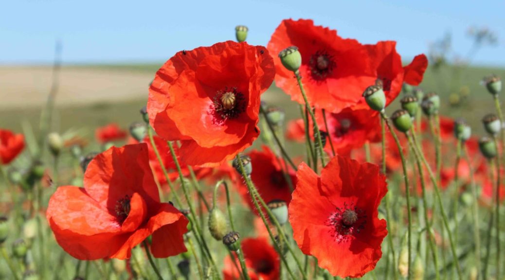
This is lovely, varied walk is full of twists and turns, a canal and a river and paths not marked on maps! With a bit of history thrown in it’s perfect.

There are two opt-outs. The first is to stay in the park.  There are ample walks, an art trail (two pieces from which we all see) and a park café. The second opt-out is to return after the visit to Muiravonside Kirk by returning to cross the canal at Haining Bridge and following the route back which you will take alongside the canal. This cuts out three miles, in wet weather almost all  mud.

Park in the main carpark in Muiravonside Country Park. The Satnav postcode of EH49 6LW gets you to the village of Muiravonside but then misdirects you. If you’re following this, once in the village, keep on the road in the direction of travel and turn right into the park.

The Loan, Whitecross EH49 6LW, United Kingdom

To get there, for those without satnavs.

Take the M8 east (towards Edinburgh for the geographically challenged) and then the M80 off left to Stirling, Kincardine Bridge etc. Follow the M80/A80 as per usual, until you come to the M876 marked Kincardine Bridge, Falkirk and Grangemouth. (Just before the blue motorway sign you’ll see the brown tourist sign for the Falkirk Wheel.) Take this motorway to the left: the inside lane goes off on the M876 while the M80 continues on towards Perth. About seven miles further on ignore the M9 sign going north (on your left) and continue on for about a mile until the M876 merges with the M9 coming in on your right. It’s really very easy – just keep driving. When the motorways merge, the inside lane goes off to Kincardine Bridge so get into the middle lane and make for Linlithgow, Grangemouth etc. You sweep round Falkirk and make for Junction 4. Look out for the enormous Kelpies (horses’ heads) on the Forth and Clyde canal. Leave the motorway at Junction 4 and come down the slip road to a large roundabout. Go right round the roundabout ignoring a road to a ski slope, a slip road back on to the motorway and the A803 to Linlithgow ( and ignore  the seductive brown signpost to Beecraigs Country Park) and take the next exit, the A801 signposted to Bathgate, Livingston and Maddiston (and the M8). Drive straight down this road for two miles till you come to Bowhouse roundabout. Turn first left on the B825 (signposted in brown to Muiravonside Country Park) and half a mile on you’ll come to the Country Park on your right.

Turn right into Muiravonside Country Park. Drive right up the magnificent drive way, past the overspill (woodland) car park on the left , to the main car park and turn in left for cars as directed. The journey from Glasgow is exactly 35 miles and should take about 40 minutes.

Toilets: there are two sets of toilets at the main car park: the nearest are at New Farm next to the car park; the others are at the café which, in fact, you walk past on the walk. 

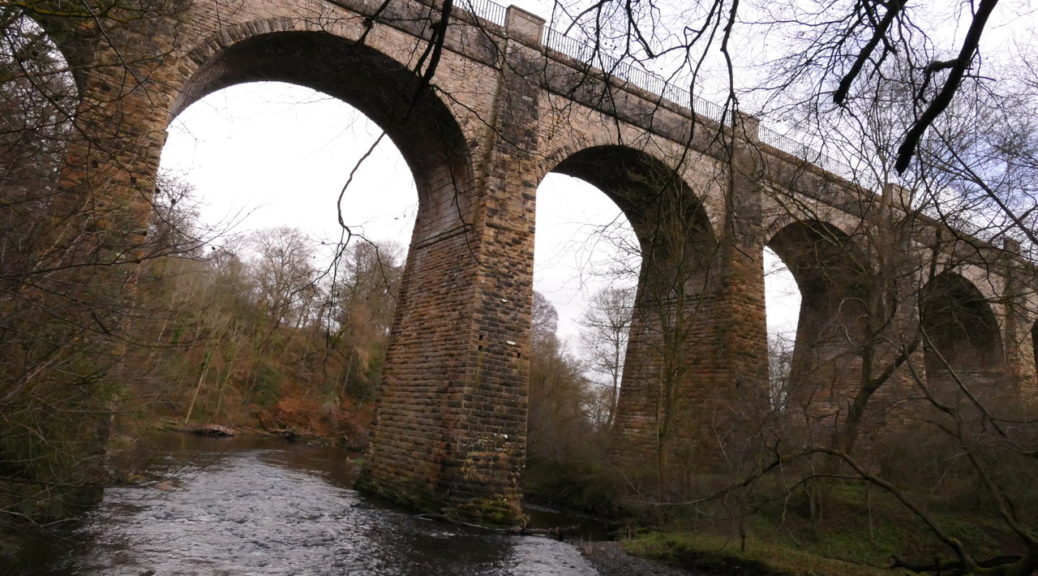
From the main car-park walk back down the main driveway to a substantial signpost pointing left along a good track towards Candie. Turn left here and, ignoring a signpost directing walkers back to the river, continue on to an unnamed, unmarked path above the farm of Redford. This unnamed path is best noted by the angle of the track, which is marked, to the left. On the map it looks as though there is no continuing path but in fact a good path curves round and down just above the farm. It joins the official route along the River Avon just above the river. Turn left here to make your way down a steep, muddy slope. (You may find it easier to keep to the fence until you reach the river.) At the bottom turn left to  follow the river through a delightful meadow and then through the steeply wooded section of Carriber Glen. The exit is barred by a landfall and you are, gratefully, directed up to the café and toilets. You continue above the river stopping to admire the ‘Owl’ bench and owls in the tree which are part of the ‘Art in the Park Trail’. Go through the Stirling family cemetery which is strangely moving. The path slopes down eventually, joining an old mill lade, and coming,as directed, to the old Mill and the Park offices.  Continue along a particularly beautiful stretch of the River Avon to the magnificent aqueduct towering above you. Steep steps take you up the considerable height to the Union Canal towering above you. At the top you turn back on ourselves to the canal. Once on the canal bank,  turn right towards Falkirk and away from Linlithgow but if you’ve never been here it’s worth walking back along the aqueduct to admire both the river below and the engineering miracle.

You now follow a metalled path along the canal bank, passing Bridge 49. Pass a canal inlet with tied up barges. Note when you come to Haining Bridge since this will be the return route for those opting out. However, it is well worth continuing  to Muiravonside Kirk. This is hidden to the right but is easily found at a small burn flowing over the canal path and into the canal. Just before this burn, there is a path over a broken wall with stone steps which takes you into the large car park at Muiravonside Kirk. (If you wish to avoid the additional 3 miles, turn back here and retrace your steps to Haining bridge where you can cross the canal and continue down along the opposite side. When you come to a junction of paths, continue straight on and follows the notes below.)

However, it is worth at least glancing at the cemetery, before continuing your way parallel to the canal path. From here there are fine views of Almond Castle. This little path soon rejoins the canal towpath.

Continue along the canal bank to Bethankie Bridge. Just across the road below, a fine set of steps goes down to the right on to the road. The road then goes under the canal by a narrow tunnel. This part of the road is also used by cars who exercise caution but who cannot see the tunnel until they are almost on it. Beware! Just under the tunnel, to the left, is a Public Footpath sign directing walkers through a gate and up through the woods. The path climbs to a driveway coming up from the road and into The Haining. Cross this driveway, following a public footpath sign. The path should go straight up the hill, but locals have struck off diagonally to cut off a corner. At the top, the official path comes in from the left and continues to the right but, again, the locals have continued diagonally. It all meets up by Parkhall Farm where you are directed by the footpath sign straight down and then to the right. This emerges at a metalled road with the path ahead barred for obvious reasons! On the metalled road, turn left and follow the road across the Manuel Burn.At the T junction, turn left and then, at signpost, cross the road and climb up beside some trees towards some houses. The first part of this path can be very muddy. However, as you circle round the houses the path improves and comes out on a lovely country road with views across the Bathgate Hills and towards the Forth Bridges. Pass signposts to Muiravonside (on the right) and Haining Bridge (on the left) both of which you ignore.

As you near the Union Canal a signpost directs you to the left and down on to the canal bank. There are three choices. One sign points back to Haining Bridge where the ‘Opt-out group’ will come in. Those coming from Haining Bridge will go straight on. One sign points to the canal which simply goes to the canal bank then back up onto the road. The third sign points towards Muiravonside and continues under the road. Those joining here will turn left at the signpost towards Muiravonside.

The next section is a delightful soft path along the canal but slightly above it. You soon reach a picturesque inlet where canal barges  are tied up. Some of the barges are residential. There are benches here to sit and admire the view. There are several paths leading back to the park but the best is to continue past this inlet with the barges, following a signpost to Muiravonside, which comes out in the car park of Bridge 49. Go up through the car park, turn left at the road and then, just before the bridge over the canal, cross the road and take the signposted track back into the park. At a major junction of paths turn right and follow the track back to the car park.

A circular walk around Milton

Getting to the Forest Enterprise car-park at MILTON near Aberfoyle is easy. Take your favourite route to Aberfoyle (generally the A81 which you pick up either at Maryhill Road or Canniesburn Toll). The A81 takes you through the east end of Milngavie; round the roundabout at Homebase, etc (sign-posted to Strathblane); past the waterworks; on to Strathblane, Dumgoyne, Gartmore House to the new roundabout outside Aberfoyle where you turn left towards Aberfoyle.

YOU MIGHT LIKE TO STOP FOR THE TOILETS AT ABERFOYLE NEAR THE TIC

Then go back onto the main street and continue through Aberfoyle (without turning right up the hill) and drive straight on towards Milton (and Kinlochard and Stronachlachar). After just over a mile, at the restored mill in Milton, turn left off the main road, cross a bridge and follow the road around, bearing right (I think!) at the Forest Enterprise signpost. Turn left into the main car park.

Stirling FK8, UK

The Walk

Your walk starts off straight over at the cross-tracks you drove up and continues through the forest to Lochan Gleannan, The lochan is lovely but the next two miles may be a bit of a hike through the forest although you get fine glimpses of Loch Ard below. Then it all gets interesting again as you reach the Aqueduct, the Valve House, Duchray Bridge and Duchray Cottage. .

Continue on past Duchray Castle to Lochan Splingen. If you have time you can go all the way round to take in all the sculptures.

The Semple Trail

To get there
Take your favourite route out of Glasgow (probably via the Clyde Tunnel) to join the M8 towards Greenock.  Exit the M8 at Junction 28A onto the A737 going south towards Johnstone.  Continue past Howwood and turn right onto A760 (Lochwinnoch).  At the box junction turn right into Lochlip Road (over Calder Bridge).  Continue until the sharp left hand corner where you turn right into the car park.  Parking is free.

The Walk:  The Semple Trail – 10.0 miles (Options:  5.0 miles from Howwood; short additional extensions)

The walk starts at the car park and is well signed.  Follow the cycle track southwards to the end of Castle Semple Loch, cross the bridge and turn left .  The track joins the pavement just before the RSPB reserve.  Continue on the pavement over the railway bridge at Lochwinnoch Station, past The Loch House (where we will be eating) and up to the roundabout at the junction with the A737.  Carefully cross the A737 and take the small road opposite.  The road climbs gently to Belltrees Road where you turn left. Continue on this road past Newton of Belltrees until High Trees where you take a smaller track to the right. Follow this country track to the end and go through the gate opposite onto a grassy path with the sound of the Linnister Burn to the right.  Cross the burn using the bridge.  The path gently climbs to join a minor road at North Muirdykes.  Turn right for 200m and then turn left onto the B776 and follow the pavement downhill.  On a good day there are wonderful views across the valley and to the mountains to the north.  Just past the Catholic Church (on the right) take a small path to the left (signed Beith Road).  This joins the B787 (Main Street) at the Church of Scotland.  Cross the road and turn right for 100m and follow the road left (Station Road) towards the railway station.

Continue on this road over the railway line, the main road and Black Cart Water.  Just past a parking area on the left turn left over a stone style to follow a track across farmland.  Note the Temple on the hill to your right which can be accessed by an optional detour once the track swings to the right as it approaches the north end of Castle Semple Loch.  Follow the path until it joins the cycle track (NR7) at a gate and turn left towards Lochwinnoch.  Cross the bridge at Castle Semple and take the path down to the right.  At the gate turn left.  Pass and/or visit the Collegiate Church which is on your left and the cascades on the right.  Continue on this track until an obvious split.  Go right through a gate and into woodland (Parkhill Wood).  Take the first obvious path to the right and follow this (generally keeping right when there is a choice) as it climbs and wends its way through the trees.  The path skirts the northern edges of the wood with views over the trees below.  Where the path splits at the southern end of the woodland take the path that rises slightly to the left and then another rising path to the left shortly thereafter.  The gentle climb takes you to a Lookooterie (a lovely viewpoint) on Parkhill.  Follow the path down the other side of the hill.  There is a short stepped section before the path swings left.  At the path junction turn right and almost immediately right again towards the Grotto.  Follow this path to the bridge that crosses Blackditch Burn and turn right.  Exit the wood through the gate, cross the cycle path, and walk down to the loch side.  Turn right and follow the track back to the cars.

Keep your eyes open: Interesting artwork/seats.  Historic buildings, including a folly; the cascades; the ice house.  Butterflies and birds.

Après-walk Meal: Arrangements have been made for a meal at The Loch House.  The ‘menu’ is attached for information purposes only.  It includes parking arrangements, directions and time.  Meals cost from £9.50.

Callander to Kilmahog Circular

Park wherever you can find a space in Callander.

The Walk: you may find it helpful to purchase a copy of the map of the excellent way-marked paths around Callander from the Tourist Information Centre or downloaded from the website. The ‘coloured dots’ in the notes below refer to this map.

UK

Begin by walking along the Main Street towards Stirling etc. and continuing past the junction for the road up to the Bracklinn Falls on the left and the Roman Camp Hotel on the right. A little further on a sign post directs you down a narrow path (blue dots on the map) which soon opens out, undulates along a low ridge and then makes down to the river. The stretch along the river is lovely. Continue along the very good path, past an information board and platform for fishermen, to where the path is forced inland up a set of steps, across a field and on to the main road at a bus stop. There are pedestrian traffic lights to allow you to continue up a track on to the old railway line. At the junction, you turn right (white markers on the map).

It is possible to opt out here by turning left and walking back along the railway line to Callander.

Turn right here and walk to the last in a row of houses on the right. Here there is a clear path on the left which leads up to the woods and saves a trek to the next corner and turning back. Cross an old wall and join a good path that continues northward, crosses another old wall and joins the golf course. We’re asked to skirt around the Greens. At Green 14 the path is indistinct but keep going and it soon re-emerges through some trees. Keep on the path, around the Greens, sometimes through attractive clumps of trees.

At Green 7, where you’re asked to wait until the bell has been rung, there is a lovely path going off to the right in the direction you’re coming from, i.e. on the right hand side of the path across from the bench and the notice. Follow this as it climbs gently and eventually emerges on the Bracklinn Falls Road where you turn left.

It is possible to opt out here by continuing down the road to the Main Road and turning right into Callander.

Continue down the road (White dots on a yellow road.) At the blue Parking sign, turn right and at the gate take the lower red-and-brown dotted route through the forest. At a viewpoint, a post with a red marker goes up hill, but you go left downhill. There are some very slippery boards here! Avoid! This path comes down to Tulipan Crescent.

It is possible to opt out here by turning left, going through the car park at the back of the Dreadnought Hotel and into the Main Road.

However, you turn right in Tulipan Crescent and go down to cross the main road (A84) and pick up the railway going in the opposite direction (red dots). Follow this old track all the way to Kilmahog where you cross the A821 but take the path immediately on the left rather than continuing to Strathyre. Follow this up to a second car park but continue on through a gate on to an excellent Woodlands Trust path above the road but well below Samson’s Stone. It comes down to the A821, crosses it and makes for the River Leny at Invertrossachs Bridge. Once across, turn left to the car-park at Coilhallon Woods. Here you have a choice:

You can turn left here on the lower path, (along a white un-dotted route) and wander along a lovely path, round a lochan and into Callander Holiday Park. Wander through the site (even in winter) to the gate at the end and down on to the Invertrossachs Road.  The road comes out at a little roundabout where the A81 goes left and up the hill to Callander. It’s much prettier and just about the same distance to turn right and go up the road to just before McLaren High School and Leisure Centre. Turn left and go down to a park, zig-jag on through the park to the pedestrian bridge across the River Leny and then on to the other side and up to the main road.

Alternatively, the main route takes the second track on the left and climbs a little up through the woods with excellent views across the hills. At a sign-posted junction  turn left and come down to a gap in the wall and the A81. Cross and follow the route above.