This video is available publicly because it contains very few personal images.
This video is available publicly because it contains very few personal images.
Beecraigs Country Park, full of picturesque surprises, is new territory for most Glaswegians. The views from even quite small lumps are spectacular – mainly because of the clarity of the air and the positioning of the lumps (especially Cockleroy) with little around them to block the views. You can see as far as Arran and, of course, the Forth Bridges (nearly three of them) and Linlithgow lying below us. At first it seems rather douce for experienced walkers, what with surfaced paths, signposts, foot bridges and viewing platforms, to say nothing of a children’s adventure play area and an ice-cream van. But within 25 minutes you are wandering down attractive, less-peopled paths. It is making a detour through Witchcraig Wood to the only War Memorial in the UK which commemorates those killed in the Korean War (1950-1953) – a sobering number and mainly Scots. If you go up to the top of the hill behind passing the Refuge Stone get tremendous views while the flat-earth-brigade can reach the memorials along the road.
To get there
Make sure you park at the Visitors’ Centre and not Balvournie or you’ll be lost before you start. The Visitors’ Centre is off-centre to the north whereas Balvournie is right in the middle so it’s easy to confuse the two. You’ll find drinks, maps, ice-creams chutneys etc and venison to purchase and toilets here.
The post-code EH49 6PL works well with a SatNav and follows the route below. You may prefer to take the M8 and go north at the end rather than the M9 and go south. There’s not much in it. The following instructions go north and then drop south through Linlithgow.
Take the M8 east and then the M80 off left to Stirling, Kincardine Bridge etc. Follow the M80/A80 as per usual, until you come to the M876 marked Kincardine Bridge, Falkirk and Grangemouth. (Just before the blue motorway sign you’ll see the brown tourist sign for the Falkirk Wheel.) Take this motorway to the left: the inside lane goes off on the M876 while the M80 continues on towards Perth. About seven miles further on, ignore the M9 sign going north (on your left) and continue on for about a mile until the M876 merges with the M9 coming in on your right. It’s really very easy – just keep driving. When the motorways merge, the inside lane goes off to Kincardine Bridge so get into the middle lane and make for Linlithgow, Grangemouth etc. You sweep round Falkirk and make for Junction 4. Look out for the enormous horses’ heads (the Kelpies) on the Forth and Clyde canal. Leave the motorway at Junction 4 and come down the slip road to a large roundabout. Go right round the roundabout ignoring a road to a ski slope, a slip road back on to the motorway and take the A803 to Linlithgow with a brown signpost to Beecraigs Country Park. Follow the A803 as it twists and winds into WestPort on the outskirts of Linlithgow. At the obvious, attractive hotel, the WestPort, turn right into Preston Road.
Drive up the hill for a couple of miles until you see a sign post to Beecraigs Country Park Visitors’ Centre and Beecraigs Loch where you turn left. Drive along the road and turn right with the sign post. The Visitors’ Centre is on the left about 300 yards down.
If you’re coming up from the M8 and Bathgate you come to the Balvournie signpost first Don’t take this! Drive on about ¼ mile to the signpost to the Visitors’ Centre.
The walk
Some of the paths are separated into walkers and cyclists, but many are seldom used and others appear to go nowhere. It wouldn’t matter if you got lost but if you want to do the walk we did you need to follow the notes quite carefully.
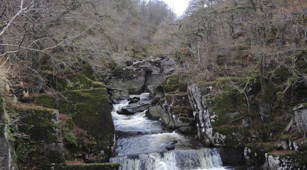
Your walk begins by taking the surfaced path (Sutherland’s Way) from the back of the car park at the Visitors’ Centre. (There is a viewing platform here giving not-very-good-views of the deer park and belted Galloways (cows) but better views of the River Forth.) The path goes downhill, turns sharp right at some locked gates and emerges at Beecraigs Loch. Turn left along a path to reach the surfaced dam very quickly. (The tempting path going straight on again comes to locked gates!) Cross the dam, with picturesque views of the loch, swans, fishing boats and a heron, and go down the wooden steps to the surfaced path in front of the fishing lodge. Now continue along the opposite side of the loch until you reach a clearly marked beaten path on the left with a red marker.
The route now becomes more rural. This good path crosses a bridge, wanders onwards then runs parallel with a vehicular road which it soon crosses. Follow the red-marked route. (The first two paths on the left, marked on the map, go nowhere!). Your path comes to a sharp corner where two forest tracks meet. Take the path to the left. (There are two paths here marked as one on the OS map: it doesn’t really matter which you take as long as you cross a burn by a foot bridge turn sharp left on a wide path and then sharp right.
The path leads down to a junction of forest tracks where you turn left. Pick up, for a while, orienteering flags of white and red triangles. Continue to a sharp bend and just past this, to the right, is a clear path which crosses a bridge and leads down to a sluice gate and pond and appears to stop. It does continue, however, veering left, over a tree stump and follows a sort of assault course beside a murky burn! The path gradually improves, so much so that a bridge across said murky burn seductively leads you astray. If you reach the bridge, you’ve gone too far. There is a path about 20 yards before the bridge on the right. This leads clearly down, across a couple of easy windfalls, to the path along the boundary of the Country Park where you turn right.
The boundary path is fine – with deciduous trees on the right and views of open countryside on the left. These make a pleasant change from forest walking. The path meanders for ages, crossing a vehicular road and then continuing to a clearing where bikes obviously keep left and walkers can avoid the bumps and keep right.
The path continues to a junction at a kissing gate marked Witchcraig Wood, a private wood with public access. Go through the kissing gate, among wild flowers, and over a long, complicated stile! The mown path (at least on the reccé) goes down to a cross paths. The path opposite goes up the hill, eventually reaching a lower ‘top’ where there are signposts pointing to the real top and the Refuge Stone or down the hill to the Korean War Memorial. At the top there are magnificent views, and a shelter with stones from all over central Scotland. You can continue over the hill and down the hill back to the stile but you would miss the War Memorial. It might be best to come back to the lower top and then on down steeply to the Pagoda. You then have a choice of road walking or going back up!
Meanwhile, the flat-earth-brigade turn right along a mown path which emerges on the road. It’s about 400 yards left along the road to the war memorial.
After the War Memorial make your way over the hill or back along the road (your choice) to regain Witchcraig Wood and then re-enter Beecraigs Country Park. Ignoring the path along the boundary, keep to the forest track for a little way. On the left you are urged NOT to use the cycle track and indeed, a little further on and running more-or-les parallel with the first path is a newly-created ‘walkers-only’ path with blue markers. This climbs a little and then, at a junction with a cyclists’ route, goes left on the walkers’ route and out to the open area with a pond, meadow, climbing area, ice-cream van and car park at Balvournie. There are toilets here.
After a break you can make for Cockleroy Hill, signposted from Balvournie. The path goes straight to the vehicular road, crosses it and enters a car park. From here you go straight up the hill. After Cockleroy Hill return to Balvournie and take the main route back to the Visitors’ Centre.
This is yet another astonishing walk in an industrial area. You strike out along Loch Thom and quite suddenly come upon the lovely views of the Argyll Hills for which the Greenock Cut is justly famous. When you reach the Greenock Cut (or canal if you don’t know this) unusually you turn right and walk along a very-much-disused stretch of canal to the road to the golf course at Whinhill. The Old Largs Road (which you will have come by) hikes you up to the track to Corlic Hill. On the best bit of the walk you pass two ruined hamlets, the first of about six cottages and the second of about four. The path then brings you down to the two Gryffe Reservoirs and back to the Old Largs Road through Dowries plantation. The last slog back to Cornalees seemed heavy going on the reccé and, indeed, on the walk itself. For almost all the walk of just over 9 miles you’d never believe that the two industrial conurbations of Greenock and Port Glasgow are just below you. Since it’s circular, it’s an easy walk to access from Drumfrochar Station but this description assumes that you have come by car
Park at Cornalees car-park. There are toilets are usually open from 10.00 and there’s a very good ‘hut’ nearby selling coffee and tea for £1.00 from dawn till dusk!
Inverclyde, UK
To get there
You can approach Cornalees from the A78 just past IBM. A signpost the next on the left, past the last entrance into IBM. directs you to Cornalees. However, it’s quicker and prettier to take the advertised ‘Scenic Route’ to Largs along the Old Largs Road, some of which you’ll be walking.
The walk
Your walk begins from the car-park turning left, as sign-posted, towards Overton (two miles). The first part is along the edge of the Compensation Loch and then the edge of Loch Thom. At the cottage take the left-hand track (not the right-hand track which leads to the dam). (Just before White Hill is a clear Scottish Rights of Way notice down the hill to a LRT on Loch Thom. The first part is apparently pathless, but the LRT along the edge is quite clear. This will take you past Killochend and on to the Old Largs Road and back to Cornaleees if you want a short cut.) At White Hill, a track from a radio mast and reservoir comes in from the left, but you should continue on, breasting the hill and then on down to wonderful views of the Argyll Hills and Greenock. Keep to the left of two small reservoirs and emerge at the canal cottages at Overton and the usual end of the Greenock Cut with the Drumfrochar car park just beyond.
Across the bridge turn sharp right through an old, rusty, wrought-iron gate, and on to a clear path beside a very reedy canal! This follows the canal a short distance apparently to a stop at a railing. However, on the left of the path, before the railing, there are some wooden steps which bring you out on to the road to Whinhill Golf Course. Turn right here to High Murdieston, then keep on the Old Largs Road, ignoring the left turn to the Golf Clubhouse.
At the track sign-posted ‘Corlic Hill’ turn left and climb gently up past Whitelees Cottage and a radio mast with ever-opening views of the River Clyde. There is a clear track going off to the right, just before a five-bar gate and kissing gate, but you should go through the gate and continue on towards Corlic Hill (sign-posted 303 metres/1200 metres – one being the height and the other the distance to it). Just below Corlic Hill the LRT goes clearly onwards and upwards, but if you don’t want to climb up take a wooden stile beside a five-bar gate just above an extensive copse of trees surrounding the first of the two hamlets.
It is essential that you find the LRT here. It is well to the right of the outer horse chestnut tree of the hamlet. If you have wandered into the hamlet, you must come away to the right and then look for the beginning of the track. It is on a line looking towards a bluff rocky outcrop to the right of the next copse with its hamlet. Don’t try to cut across the reedy bog – it is difficult and very wet.
The LRT, once found, winds very clearly to the next copse of trees with the second of the two hamlets. This is surprisingly wild. At the cottages, I don’t think it matters which way round you go, but on the second reccé I took the right-hand path, then crossed in front of the cottages, down to a gate which opened and then over a low wire fence. There are sheep dipping fences which rather get in the way but you should be able to find a way round. You are making for a bright green path which is actually the top of a pipe leading to Gryffe No. 2 and the dam between the two reservoirs.
The path goes straight across the dam, with a reservoir on either side, and over a stile or through a five-bar gate on wheels which does open. Turn right on the forest path.
The forest path winds through a harvested plantation giving views on the left of the farm at Dowrie. At a T junction, turn right – there’s no other way through to the Old Largs Road from Dowrie. Your LRT now skirts Gryfe No. 2 reservoir before coming out on to the Old Largs Road again.
Turn left here and follow the road beside the reservoir to the junction. Here turn right towards the Cornalees Visitors’ Centre away from the Old Largs Road. Another mile and you’re at the cars.
Calderwood Estate was once dubbed ‘one of the loveliest of western glens, magnificent in its grouping of craggy heights, sprinkled with trees and with the amber-tinted Calder winding through the richly wooded and festooned valley’. The history of the Calderwood estate can be traced back to the first half of the 13th century. The Castle, originally built in 1790, was the stately home of the Maxwell family. In 1845, the then owner, Sir William Alexander Maxwell, added a grand gothic frontage. The death of Sir William Alexander’s Widow in 1900, marked the end of the Maxwell lineage. The Castle subsequently passed through a number of owners, including the Scottish Co-operative Society, who worked the land and opened the grounds to the public. Sadly, by 1951 the castle had fallen into such a state of disrepair that it had to be demolished. Traces of the formal gardens and the family mausoleum are all that now remain of this once majestic country estate. Most of these paths are aggregate (plastic bottle (!), packed bark or grit ‘n stone), and are sheltered, fenced, bridged and boarded as appropriate. The exceptions are a country trail on the way to Langlands and a very muddy, but I think worthwhile, stretch at the back of Langlands Moss. Inevitably, East Kilbride intrudes occasionally but there is a surprisingly countrified bit on the way to Langlands. The route we did was about nine miles including a short wander up towards the Castle Falls a little way – towards either Trough or Black Linn and really the best bits of the park. There are several trails to suit all tastes and abilities.
Park in the car-park in Calderglen Country Park, G75 0QZ
Strathaven Rd, East Kilbride, Glasgow, Lanarkshire G75 0QZ, UK
East Kilbride is not for the faint-hearted! If you take a wrong turning you have to turn around via Carlisle (for the geographically illiterate this is somewhat exaggerated!) so getting into the appropriate lane, remembering you’re going to Calderglen and not Calderwood and being prepared to go twice round the roundabouts is helpful!
For the adventurous: if you use the postcode (G75 0QZ) with your Satnav it will take you quickly and directly, making use of the new stretch of the M74. Generally speaking, keep in the left lane until I suggest otherwise! This route takes only 25 minutes from Glasgow!
Take your favourite route to the Kingston Bridge (get into or stay in the left lane), then exit at Junction 20, West Street (left lane) and at the bottom of the slip road, at the traffic lights, stay in the left lane turning left (Wallace Street), and then left again (Dalintober Street) as directed towards the M74. Stay in the left lane to curve naturally on to the M74 (signposted Carlisle and Cambuslang). Keep in the left lane, going past Junction 1A (to Rutherglen and Polmadie) and continuing on to Junction 2 to Rutherglen and Dalmarnock. At the bottom of the slip road turn left (sign-posted City Centre/ Dalmarnock) and then sharp left again on the A724 on Cambuslang Road ‘towards the City Centre A724 (A749) Drive on to traffic lights at a major crossroads with ‘The Laurels’ opposite with a clock on the wall and Lloyd street on the right. Turn left here along what is Farmeloan Road (but not named) and drive up to traffic lights at Farmeloan Cross. (Rutherglen High street is to the right and Boots is on the opposite corner).
Go straight across (A749), signposted ‘Burnside, East Kilbride and Rutherglen Shopping Centre’, up Stonelaw Road, past the Bowling Green on the left and curving to the right beyond some woodland into Burnside. At some shops, go underneath the railway and turn sharp left along East Kilbride Road (A749).
Follow this, going straight over at the first roundabout, straight over Nerston roundabout (first exit) and straight over the next roundabout (second exit) following the A749.
At the Whirlies Roundabout (with big metal golf balls) go straight over, third exit (but it looks like the fourth) and you must be in the middle or outer lane signposted A725, Town Centre, Strathaven, etc. (The inner lane takes you off to Calderwood.) Go along what is now Kingsway to Whitemoss Roundabout where you pick up the first brown tourist sign for Calderglen Country Park. Go straight over and turn left at Burniehill Roundabout, signposted A726, Strathaven and Calderglen Country Park. You must now get into the right-hand lane (the left lane is local.) This becomes a single lane and you turn into Calderglen on the left. Drive along the estate road until you reach a no-entry sign, turn right and you’ll come to a large car park by the main entrance.
For the afeart: It’s much longer but easier to take the M8 east towards Edinburgh and then, at junction 8, take the M73, quickly followed by the M74 at Junction 1 towards Carlisle etc. (Don’t let the Junction numbers confuse you, follow the signs to Carlisle, the South etc.) Come off on the A725, just past the Bothwell service station, and keep in the right-hand lane of the three-lane slip road as you come down to a huge roundabout controlled by traffic lights. Go all the way round the roundabout (The left lane of the slip road goes off to Bellshill etc. and the middle lane becomes the inside lane and leads off into Strathclyde Country Park.) Ignore the slip road back up on to the motorway, and keep in your lane which leads to a roundabout and a dedicated lane to East Kilbride. All this should be sign-posted A725 Expressway to East Kilbride. Follow the Expressway up and you’ll come to the Whirlies Roadabout (as above.) In your case, take what is the second and main exit signposted the Town Centre, Strathaven etc. Go along what is now Kingsway to Whitemoss Roundabout where you pick up the first brown tourist sign for Calderglen Country Park. Go straight over and turn left at Burniehill Roundabout, signposted Calderglen Country Park. You must now get into the right-hand lane (the left lane is local) This becomes a single lane and you turn into Calderglen on the left. Drive along the estate road until you reach a no-entry sign, turn right and you’ll come to a large car park by the main entrance.
The walk
The walk begins from the car-park turning left at an Information Board and then right at a junction of paths sign-posted towards the BBQ area and Horseshoe Falls. At a T junction, turn left and go straight down to the Rotten Calder (so-called because of it’s colour – red – not it’s smell). This is a glorious path (snow-drop covered in March) leading to the top of wooden steps which zig-zag down to the river. Turn right at the bottom and left over the river. Turn right, away from the Horseshoe Falls and BBQ area. Then follow an all-too-short sheltered stretch by the river. At the obvious end of the path, turn right and back over a bridge, but head off left towards Langlands Moss. (You could leave here, following the top path back to the Visitors’ Centre.) Your path climbs high above the river but you are safely fenced and eventually it drops down to the water again, to wind under the Strathaven Road (tunnelled and bleak). Once under, however, the path becomes increasingly attractive. It follows the river round to a wooden bridge and a junction of paths. Turn left here – you can come back the other, shorter, way if the weather is bad. You now enter open countryside and continue following the river to Hurlawcrook Road. A dogleg right and over, takes you past the information board at the entrance to Langlands Moss. This is a gravel path and, at the junction with a board walk, you turn left along the boards. Do not step off – you are now walking over bog! There are information boards along the way and, in summer, the bog would be awash with heather! It’s a bit bleak in winter! The board-walk enters a wood where you turn left and follow the path to a clearing with picnic tables and benches.
Continue in the same direction, turning right down a path marked ‘Routes around Roots’ to a bridge. Turn right here. This stretch is very squelchy – just plough on!!! At a T-junction, a marker, again ‘Routes around Roots’, directs you right and up through a lovely path through woods and back to the board walk. Go back along the way you came.
At the T junction you can turn left and follow the track back to another entrance on Hurlawcrook Road but this way was a bit bleak and urbanised. It’s prettier to go back to the same entrance you came in. Follow the route you took on the way out. At the bridge, if you’ve had enough, go straight on to the Visitors’ Centre. We crossed back over the bridge we took in the morning to the foot of the wooden steps. There are other routes but this was the prettiest so you might as well do it twice!
However, we didn’t climb up the steps (you could leave here and go back to the Visitors’ Centre) but continued along the river. This bit is lovely again – and we followed the path up to the junction with the Tor Loop (yellow route). If the weather is kind and you have the energy, go on a bit and then return to this junction. The Tor Loop climbs up a little and then turns left to follow the Kelvin Burn. Again, this is lovely. The Tor Loop crosses the drive way by which you entered the park and enters woods. The path is dry and safe and has a pretty bridge across a nameless burn. There is a diversion to ‘The Tor’ (hence the name of this loop) which is the ‘motte’ of a ‘motte and bailey castle’. Soon it parallels the outward drive from the park and brings you plump back into the car park.
The route is a picturesque ‘lollipop’ including all the ‘best bits’ of an old and fascinating walk known, presumably, to the locals but only now hitting the wider literature. I would guess that you will have beeen as astonished as I was to find this lovely walk just off a busy dual-carriageway thoroughfare, not far from Barrhead and running parallel to the M77. One minute you’re in a very busy, urban centre among the supermarkets and traffic and literally five minutes later you’re standing in a picturesque glen. East Renfrewshire has formed a number of paths around three picturesque reservoirs and we added two more lochs and a woodland walk. It’s totally surprising and lovely.
Glasgow, Glasgow City G53, UK
PARK in the car-park of ‘The World Buffet’ restaurant who have kindly agreed with East Renfrewshire to allow parking on their premises. You should park neatly in the larger car-park, fronting the main road (the A726), and well away from the entrance to the restaurant which will be very busy at lunch-time.
TOILETS The World Buffet toilets are for customers only and the usual practice, mentioned on every website, is to use the toilets at Sainsbury’s. To get there follow the instructions below to The World Buffet but as you come off the M77 and turn right on to the A726, look almost immediately for a large Sainsbury’s sign on the left and turn in JUST BEFORE SAINBURY’S. This takes you up to a roundabout which you go round to exit on the right, and then up the ramp, past a huge car park on the right, to the car park for Sainsbury’s itself. Afterwards, come back to the A726 and turn left to continue past the first road (Southpark Village) to the SECOND LEFT which has a large ‘World Buffet’ cylindrical advert on a pole. Turn left here, left again into the restaurant, and then park as above.
To get to The World Buffet Restaurant car park
(Note, the Post Code, G53 7RN, takes you too far. Use it to get to the A726 to Paisley and then follow the instructions below.) It will take about 25 minutes from Glasgow.
Otherwise begin by taking your favourite route to the Kingston Bridge and the M77 towards Kilmarnock and Ayr. If you come over the Kingston Bridge keep in the lane third from the left with the M77 on the gantry above. (The first two lanes on the left go down to West Street etc.) Stick with the inside lane on the M77, ignoring roads beside you which seem to be the M77 and which will soon join you. Stay on the M77 past Silverburn, with the Park and Ride and the brown Burrell notices, and go on to Junction 3 signposted ‘A726, Paisley and Barrhead’. I would keep in the outside lane on the slip road until you approach the junction when you should get into the middle lane of the three so that you are in the middle lane as you turn right signposted ‘Paisley and Barrhead’ to go back underneath the motorway. Keep in the middle lane and ignore the slip road going off on your left (to Southpark and Darnley) and go straight on towards Sainsbury’s. Turn left at the traffic lights for Sainsbury’s if you wish to use their toilets: otherwise continue on past a road on the left to Southpark Village and take the next road on the left to turn into the World Buffet Restaurant. You’ll see the cylinder advertising the restaurant on a high pole on the left, just before the entrance.
The walk
The walk begins by turning left on the lane outside the restaurant, away from the main road, and turning left again at the first entrance into a picnic area with various signposts. We ignored the direct route and took the path sign-posted for the Southpark Village entrance, crossing a picturesque bridge and turning right at the next junction to go alongside the left hand side of the little pond. At the end, the ‘pond’ path climbs a little to re-join the Southpark Village path and you follow this up to the main route up through the glen. Dog-leg left and right here, going between two piles of grit, to pick up a slightly higher path and, at the immediate junction, turn right to follow a lovely path through the woods and along side the rushing Brock Burn..
(The grit is going to be used for planting to prevent fly-tipping! If you miss it, or it’s planted, go on up the main route just a little, take the path on the right and then double back to a junction: this time the take the path on the left.)
A set of sturdy steps helps you to gain height easily and at the top bends left to the main route again. However, as the path bends left, look out for a path on the right. Turn right here, across some duckboards and follow a pretty, but muddy, path wiggling up through the woods. This is much preferable to slogging it up the road!. At the top, it re-joins the road at an idyllic view of a spectacular waterfall!!! (Well it was in February!)
The road curves round right and then left to the first of five reservoirs, this one the Waulkmill Glen Reservoir. Again the signpost gives a number of options. Follow the ‘road’ beside the reservoir, and you soon have Littleton reservoir and the Brock Burn on your right. The road ends alongside the Ryat Linn Reservoir and another lovely waterfall just below the Aurs Road. THIS IS THE END OF THE STICK and a nice place for a picnic.
To do the lollipop, your path turns left and goes up to a safe place to cross the Aurs Road. Cross over and for the next mile and a quarter you are walking round the Balgray reservoir to a car park with two picnic tables another nice , but rather bleak, place for a picnic. It is usual to retrace your steps from here.
If you want to do the full round, continue alongside Balgray Reservoir, as sign-posted, over the railway line, with fine views across Paisley, and come down to Springfield Road. A slight dog-leg left and right will take you t across the road to take some steps down to a safer road which you follow downhill (to the right). Where the side road runs out make for the Aurs Road (a continuation of Springfield Road) coming out at Albar Estates. You have to cross this road at a terrible bend so be prepared to nanny each other! At two lamp-posts up the hill a little (10 yards?) is a small path running alongside the Albar Estate entrance. The path soon grows up, goes into some trees, across a burn on a plank and up a track. The next bit is fine, with open views to Dumgoyne and Knockupple. It continues up to the railway line AND THEN GETS LOST! THE PATH CURVES ROUND AND FOLLOWS THE RAILWAY LINE BUT THE PATH YOU WANT, MARKED ON THE MAP, HAS BEEN OBLITERATED. Immediately under the railway line go straight up a muddy bank and pick up a path which makes for what we have come to call the ‘Oblong’ Reservoir. Cut through left to higher ground and take a come-and-go-path towards the wall on Aurs Road. As you get near the wall, you can see a gate on the left which you may as well make for since it’s open. Through here turn left and come back to the stick.
This time, take the road straight down, ignoring the little path through the woods. Just past a ruined building and through two pillars, turn left and either go down the first on the right (shorter) or take the path you came up (longer but prettier!). You come out by the two piles of grit and either cut through here or a little further on to the main route. Turn right and then immediately left for the ‘official’ path off the road (between two round stone pillars) which is shorter and prettier to come back to the start of the walk.
The Almondell and Calderwood Country Parks have been created from two adjoining estates and amount to just over 200 hundred acres of rivers and woodland hidden to the east of Livingston between the M8 and the A71. The Almondell Estate is exceptionally well-laid out with beaten bark paths, tarmac driveways, bridges, play-areas, toilets and a Visitors’ Centre. The Calderwood Estate is also way-marked and bridged, but is much wilder and rougher. In both, you would never dream that you are a few miles from the capital city and the rivers Almond, Linnhouse and Murieston are spectacular in spate. There are numerous waterfalls, weirs, tumbling rivers and burns, islands and quieter mill lades. It is all exceedingly photogenic and picturesque, not least the various aque-and-via-ducts and bridges of various kinds.
West Lothian, UK
Park in the NORTH CAR PARK of the Almondell and Calderwood Country Park. To get there the postal code for the park is EH52 5PE and worked well with the satnav. Otherwise, getting to the North Car Park is very simple and should take about 40 minutes from Glasgow. Leave Glasgow on the M8 heading east towards Edinburgh, and stay put for about 30 miles until JUNCTION 3 (not Junction 3A which you come to first) where you leave on the left to take the A899 to Livingston (and West Calder). You swing around the slip road, back over the motorway and come to the roundabout with a whalebone structure in the centre. Take the first exit down the main Livingston dual carriageway but after 800 yards take the road to the left sign-posted Pumpherston and Uphall Stations. (There are a pile of Livingstone estate names – ignore these!). You come down to a main road where you turn left and at the next roundabout also take the first exit on to Houston Road and the Houston Industrial Estate. At the traffic lights, turn right on the B8046 (Pumpherston Road) towards the unprepossessing village of Pumpherston. The road on the left beside the Bay Leaf Restaurant, has been blocked off and is now a dead end. Instead, at the traffic lights in Pumpherston, go straight ahead and take the sign to Almondell and Calderwood Country Parks.
Turn left here left here and continue until you reach s big sign to Broxburn pointing left, but the sign for Almondell and Calderwood Country parks is hidden until you’ve actually turned right! Drive down this single-track country estate road till you come to the Estate Entrance with two traditional pillars and a lodge. You are not allowed to drive any further, but are encouraged to enter the North Car Park on the right.
The walk
When you are booted up and kitted out then make your way to the other side of the large car-park, opposite the car entrance, to a path between a dog-pooh bin on the left and a recycling bin on the right. Follow this made-up path as it curves round and down to the left (ignoring a small local path which goes straight on) to a set of steps down on to the main drive way. At the bottom of the steps you’ll come to a sign-post pointing right down the driveway to the Visitors’ Centre. At the Centre, you can have coffee, pick up a map and other useful information and use the loos.
After coffee, leave the Visitors’ Centre at the front entrance and turn right, through the garden past the toilet block and turn right again to the Nelson Mandela suspension bridge across the River Almond. A path along a mill lade continues to the left but you strike up the series of wooden steps straight on and up. On our walk these were muddy and slippery but there’s a good hand rail. At the top turn right to follow the course of the river, but high above it. This excellent path meanders through larch woods, with open fields on the left and the river below. By-pass the Nasmyth Bridge and come out on the main drive way to the South Car Park which is currently closed. Turn left to continue along this driveway to the imposing exit/entrance. Turn right for 50 yards along the pavement and then cut back into the estate on a path sign-posted ‘Camps Viaduct 0.4 miles’. (Your path is just by the metalled entrance to some houses – look for the angled sign-post on to the path.) The old railway line takes you through pleasant countryside straight on to the viaduct high above the River Almond. Immediately over the viaduct is a set of steps on the left leading down to a path across a hump-backed bridge (the Dale Bridge) across a mill lade and on to the main estate path along the river. You will see an attractive shelter to the left, and look up to appreciate the remarkable workmanship of the viaduct. If you dog-leg slightly left and right you can pick up a grassy and lovely path alongside the river.
At the Pipe Bridge, turn left across the bridge and then follow the path through a particularly attractive area. There’s a sewage farm on the left but you don’t see much of this on the outward leg. Just before a metal bridge going straight into the village of Mid Calder turn left down a lovely path, and just before it emerges on the road turn right, down some steps, under the road and across a purpose-built metal bridge. Almost immediately you turn left again across another such bridge and you’re into the Calderwood Country Park. There’s an information board and map, and the return path is seen coming in from the right. Go straight on here, following the path west, on the south side of the plateau and high above Linnhouse Water, to a junction of paths. Oakbank is sign-posted to the left and Murieston to the right. Turn right and at the next junction, continue downhill to the Murieston Water (sign-posted Murieston), turning right at the river bank. This muddy but delightful path takes you along an idyllic stretch of the river and then back up to the higher path at the Spottiswood junction and Information Board. Continue straight on here.
At the time of writing, there was a huge puddle but you should follow the general line of the path. It is easy to wander too far into the central part of the plateau which is pathless. Keeping in line with the direction of travel around the puddle will bring you back to the information board at the entrance to the Estate mentioned above. Then cross the first metal bridge, turn right across the second, under the road, up the steps and back along the path round the sewage works to the Pipe Bridge where you have to turn left to cross the bridge and right to take the path home. Go past the hump bridge which brought you down from the Camps viaduct, under the attractive wooden shelter to the aqueduct. You have a choice of routes here – either is pleasant. But to vary the walk cross the river at the aqueduct, walk up the side of the Mill lade, cross the Nasmyth Bridge since you by-passed it in the morning and take the Red Route path alongside the river. This is a lovely stretch, going along the back of the Visitors’ Centre to the path you took in the morning. Turn left here, go up to the driveway and turn right to go back to North Car park and the cars.
The first part of this walk is by far the prettiest but the second part stretches the legs and offers variety. You set off on a very lovely path along the River Leny. After the river walk and the railway track there’s a long gentle climb up to the Falls. Thereafter there’s a lovely woodland walk back down into Callander. The Longer route takes you across the meadows to Kilmahog and then climbs a little befoe returning through Coilihan Woods. The walk is as flat as you’ll get in the countryside – but oh so beautiful and with wonderful views. The Tourist Centre will have maps with walks around Callander which match the coloured posts en route.
Callander, Stirling FK17, UK
Park in Callander. As this is a circular walk it doesn’t matter where on the route you park, but there is a charge in each of the two main car parks (down by the River Leny and behind the Dreadnought Hotel). Outwith the height of the tourist season here is ample free parking in Callander: round Callander Kirk, along the Main Street out towards the Roman Camp Hotel, and up and along the disused railway line, for example at Glenartney Road. You could also start at Kilmahog. Just check that wherever you park there there isn’t a time limit.
To get there take your favourite route to Aberfoyle (generally the A81 which you pick up either at Maryhill Road or Canniesburn Toll). The A81 takes you through the east end of Milngavie (past what was the East Dunbartonshire Council Buildings and is about to be a Hotel); round the roundabout at Homebase, etc (sign-posted to Strathblane); past the waterworks; on to Strathblane, Dumgoyne, Gartmore House to the roundabout outside Aberfoyle where you turn right to Callander, still on the A81. Drive past Braeval and the cottages at Lake of Menteith turning sharp left with the A81 and following the signposts to Callander. At the mini-roundabout, just past the McLaren High School and Leisure Centre, turn right to go up the hill into Callander, and right or left at the traffic lights depending on where you’re parking.
The Walk
Since the first part of the walk is the prettiest, you may like to begin the walk by continuing along the Main Street and past the junction for the road up to the Bracklinn Falls on the left and the Roman Camp Hotel on the right. A sign post directs you down a narrow path (blue dots on the map) which soon opens out, undulates along a low ridge between the town houses and the river and then makes down to the river. The stretch along the river is lovely. Pass an information board and platform for fishermen, and continue to where the path is forced inland (just over a planked deep stream) up a set of steps, across a field and on to the main road at a bus stop. There are pedestrian traffic lights to allow you to continue across the road and up a track on to the old railway line. At the junction with the railway line, turn right (white markers on the map).
The next part is very easy walking and very beautiful. Continue with the track past Auchenlaich House (ignore both the path parked ‘Private on the left and the Keltie Bridge Caravan Par on your right) and begin to climb gently but steadily. There are glorious views of Callander and Ben Ledi beyond. At the junction (with a notice saying Bracklinn FC to the left) turn right. This soon emerges on the main Bracklinn Falls path (purple dots on the map). However, it is particularly beautiful to go straight on here (instead of turning right to the Falls) on a new path created when the bridge was replaced. This is very short but brings you along the river upstream from the bridge.
After visiting the Falls get back on to the main path (purple dots) either by re-tracing your steps back the way you came down (gentler) or stepping between two boulders on your left and going straight up some steps (steeper). Continue along to the Bracklinn Falls car park. There have been forest operations along the route which, while untidy, have opened up the views. At the country road going up to Braeleny (through a huge gate), turn left downhill. (White dots on a yellow road.) At the blue Parking sign, turn right and at the gate take the lower red-and-brown dotted route through the forest. At a viewpoint with a bench, a post with a red marker goes up hill, but you go left downhill. There are some very slippery boards here! Avoid! This path comes down to Tulipan Crescent.
The Short Cut
If the weather has been dry for a couple of weeks you could turn right, cross the road, go down to the old railway but turn left around the car park (orange dots on the map). Alternatively, turn left in Tulipan Crescent to pick up the railway going in the opposite direction (red dots) and wiggle your way either along Ancaster Road (red dots) or the old railway (blue dots). (To follow the Ancaster Road route, from Tulipan Crescent follow the old railway track through to the car park and from the far, top corner of the car park go up some steps and across the bridge into Ancaster Road, and turn right.) Either way, you reach the Main Street easily.
The Longer Route
For a longer walk, cross the main road (A84) from Tulipan Crescenet and go straight over to the railway line turning right towards the signal. Follow the railway line towards Kilmahog. (Notice the very clear outline of a Roman camp on the right in the meadows as you near Kilmahog.)
At Kilmahog, cross the country road (A821) and take the off-road-path running parallel to the road on the left. Follow this to another car park on the right but go straight on to pick up the Woodlands’ Trust path contouring round the hillside parallel with the road on the left and under Samson’s Stone on the right. This comes down to the A821 opposite the Invertrossachs Road. Cross the A821 and go down the road towards the bridge. Cross the bridge and turn left. Follow the road to a car-park on the left. The main path (green dots) goes up directly in front of you. However, it is shorter and prettier to take the path on the left and follow this to a wee lochan at Callander Holiday Park. Follow the signs through the park to rejoin the Invertrossachs Road. Take the road to the junction with the A81. You can either cross the River Leny on the road here, or turn right at the roundabout, cross the road and take the path on the left to go down to the pedestrian bridge and up South Church Street.
The centrepiece of this walk is undoubtedly the canal aqueduct at Lin’s Mill where the Union Canal crosses the River Avon. With a little effort it’s possible to view the river below from both sides of the canal without actually getting your feet wet! To get to the aqueduct you follow the canal feeder from the Visitors’ Centre in Almondvale Country Park along a picturesque path through open countryside. At the aqueduct you pick up the Union Canal which takes you to the Brox Burn which, would you believe, is in Broxburn! There’s a short stretch beside a housing estate but after about half a mile the path becomes prettier. You eventually come past Uphall Station (where the walk officially starts) and the next 2 miles on a disused railway line a bit sore on the legs. However, as you re-enter the Country Park the scenery improves and suddenly you’re on the Camps viaduct which carried the mineral railway you’ve been walking along across the River Avon. A beautiful stroll through the autumnal woods of the country park and we’re back to the Visitors’ Centre.
You can do this walk from Uphall Station which gets the boring bit over first. However, parking is easier at Almondvale, it’s a much prettier place to start, and there are toilets and a coffee machine.
Park in Almondvale Country Park
West Lothian, UK
To get there, the postal code for the park is EH52 5PE and works well with the satnav. Otherwise, getting to the park is very simple and should take about 40 minutes from Glasgow. Leave Glasgow on the M8 heading east towards Edinburgh, and stay put for about 30 miles until JUNCTION 3 (not Junction 3A which you come to first) where you leave on the left to take the A899 to Livingston (and West Calder). You swing around the slip road, back over the motorway and come to the roundabout with a whalebone structure in the centre. Take the first exit down the main Livingston dual carriageway but after 800 yards take the road to the left sign-posted Pumpherston and Uphall Stations. (There are a pile of Livingstone estate names – ignore these!). You come down to a main road where you turn left and at the next roundabout also take the first exit on to Houston Road and the Houston Industrial Estate. At the traffic lights, turn right on the B8046 (Pumpherston Road) towards the unprepossessing village of Pumpherston. A few hundred yards on, just before the Bay Leaf Restaurant, there’s a sign on the right pointing to the road on the left: Drumshoreland Road, Pumphertson and Uphall Stations and Almondell and Calderwood Country Parks.
Turn left here, go through a series of chicanes and then travel about a mile along an increasingly countrified road to a junction. There’s a big sign to Broxburn pointing left, but the sign for Almondell and Calderwood Country parks is hidden until you’ve actually turned right! Drive down this single-track country estate road till you come to the North Entrance and turn right and park. I the opposite corner of the car park, by an information board and dog pooh bin, there’s a path which meanders parallel to the main drive way and saves walking on a metalled surface. There are several paths off this to join the driveway.
The walk
From the Visitors Centre, with your back to the centre, turn right and follow the path past the toilets, across the play-park and down to the path along the river. Continue in the same direction to the suspension bridge which you cross giving lovely views of the River Avon. Go up the hill a little but, where the steps continue on up, turn left along an idyllic path beside the canal feeder. The next three miles are very pretty with the little burn running beside you, open countryside on the left and frequent little stone bridges and sluice gates and stuff. At the end you have to climb a steep set of steps to reach a rough track where you turn left.
When you get to the Lin’s Mill aqueduct it’s worth spending some time here so at the junction of paths just before it first go right to reach ‘this’ side of the canal, a turning and berthing basin and views along part of the Union canal which you don’t do! However, you can turn left along the aqueduct with spectacular views of the River Avon and Kirkhill Wood below. Retrace our steps to where the rough track forked but this time take the left–hand path which goes down to the river itself and underneath the aqueduct. The advantage of this is that it avoids a set of steep steps down, but gives very good views of the river and the aqueduct itself. Go under the aqueduct and climb up a set of steps to get to the other side of the aqueduct. If anything, the views are even better but in any case you need to be on the other tow-path.
This section is the the ‘Link; between The John Muir Way, which finishes/starts at Dunbar and the Southern Upland Way, which finishes/starts at Cockburnspath. Even if you are not embarking on either of these great ways, this is a wonderful walk in itself. You will need to use local transport or a taxi – or walk it over two days beginning at each end and going half way. Note that you are following the final, unofficial section, of the John Muir Way (JMW). At the time of printing, you won’t find this section in any of the current Guidebooks to, or maps of, The John Muir Way which officially ends/starts at his birthplace in Dunbar. However, very recently it was decided to extend the route to Cockburnspath to join up with The Southern Upland Way (SUW) which wanders through the Borders to Portpatrick. Even the official end of the JMW Link ends in a layby on the A1.! So you follow a local route to Cockburnspath and then the SUW down to Cove. The JMW Link is well sign-posted as such. The SUW short section is the denoted by the traditional Scottish logo for a National Trail – thistle within a hexagon.
Start either in the Shore Road car-park or at the Leisure Pool (although you’ll miss one of the best bits if you skip the first mile or so! Both car-parks have toilets.
East Lothian, UK
To get to the Shore Road car park go through Dunbar on the A1087 to West Barns (pub on the left) then signs to the Bellhaven Bay Caravan Park.. Turn left down Shore Road and drive to the very end. There is an Information Board, and magnificent views of the John Muir Country Park, Berwick Law and the Bass Rock.
To get to the Leisure Pool continue along the A1087 to Dunbar Leisure Pool, Castle Park, Dunbar EH42 1EU
Section 1: 1.41 miles.
Your walk begins immediately on a good path just above the shore line and weaves beside the sea between the golf course and the rocky beach below. At the end you step through an archway to a stunning view of the castle. Turn right for the Leisure Pool where there are toilets. and the coach will be waiting.
Section 2: 5.65 miles. This is a very easy section. It begins just beyond the entrance to the Leisure Pool where a ‘John Muir way Link signpost directs you left, round the castle and down to the picturesque old harbour. The Link (sign-posted) winds its way through the back streets of Dunbar and then out on a path between the seashore and a golf course. You are (continuously) asked to wait until golfers have played their shots, and to speak quietly. Your path follows red posts and you should keep as close to the shore as possible, only joining the golf course road as directed.) At the end of the Links go through Catcraig picnic site and on to Barns Ness picnic site where there are toilets. Then make for the lighthouse, by-passing it eventually by turning right, before following a lovely track, just inland to Skateraw Farm. There are more toilets here.
Section 3: 1.68 miles. Without transport you will have to continue round Skateraw Cove turning left behind the toilets and then climb up a little to by-pass the rocky headland. The path winds down again to the northern side of the Power Station where an obvious promenade, named the Coastal Walk and next to steel gates not through them, goes right around the outside of the Power Station. It emerges at the car-park where a clear John Muir sign-post points left and left again along a metalled road to emerge at Thorntonloch. You are right beside the sea but the concrete is hard going.
Sections 4 and 5: 4.67 miles including the 0.66 miles down to Cove Harbour and back to the coach. This is the most attractive section in that you have a variety of low cliff top, seashore, wooded valleys, farm fields, a picturesque village and eventually drop down to the Smugglers’ Tunnel to Cove harbour.
Start from Thortonloch car-park (toilets) and make your way down to and along the sandy beach to a hidden post taking you a few yards inland and very gently back up on to the low cliffs. (The official route avoids the ‘locals’ path straight up on to the low cliff.) From here you can see ahead to the much grander cliffs of St Abbs’ Head. Now follows a wonderful walk along the tops to Bilsdean Glen. A thickly wooded path takes you right down to the sea. This is the only awkward bit where you have a ⅓ mile walk along a cobbled beach. You may find it easier to walk on the smaller stones by the sea. Then take to the woods again up Dungeness Glen (sign-posted from the beach). At a junction at the top of the glen there is a signpost directing you left to Cove but it follows the road down to the harbour.
Much nicer and safer is to continue up the glen, under the road and rail viaducts, to a country road where you dogleg left and right, up beside some fields, to a signpost pointing you left to the village of Cockburnspath. There’s a Mercat Cross and a Post Office for ice-creams/water and, as you turn left for the last lap, more toilets. At the War Memorial turn left, then first right on a track on what is now the Southern Upland Way. The track leads down under the road and rail viaducts again, straight ahead in front of some cottages, crosses a country road to dogleg along a track through fields and on to the coastal path. Turn left here or you’ll end up in Portpatrick on the Southern Upland Way!!
At the end of this path is a gate with the car-park on the left. Turn right to go through another kissing gate and down a little track to the Smugglers’ Tunnel and out into the little harbour.
This is a lovely varied walk taking in a loch, several rivers, a golf course, a forest track under the hills, winding paths, The Soldier’s Leap at the NT Visitors’ Centre at Killiecrankie, an interesting train journey and a picturesque town! All the paths are good and most of the sign-posting is very clear.
You can either drive to Pitlochry or use the train. The most convenient trains are the 10.01 from Glasgow (Queen Street) to Pitlochry and the 19.06 return
Pitlochry, Perth and Kinross PH16, UK
Begin your walk from the platform you arrive on, walking to the far end of platform and down left on to a track which joins the metalled road (Armoury Road) leading down to the dam and the Salmon Ladder.). You can walk down to the dam to see the river and Ladder and pick up the path on the right going along, but slightly above, Loch Faskally. However, if you’ve done these before, locals have created a short cut from a layby on the right which is slightly easier, quicker and just as pleasant. It soon joins the path along the loch. This is a beautiful stretch.
All too soon, this winding path is blocked by The Green Hotel, and comes up to the road. Go straight across the road (the A924) and immediately turn left and then right over the railway. Use a metalled road to climb a little, past individual houses on either side. At the top, a path is sign-posted to the left going right behind the last house and then through a gate and on to a golf course. Cross to the sign-post in the middle of the gold course, as directed, and then turn right and then left following several Public Rights of Way, usually sign-posted ‘To Craigower’, and always climbing gently, to the house with the red roof (Upper Drumchorry). All this is to avoid the usual (advertised) route which takes a road out of Pitlochry and isn’t so attractive.
At Upper Drumchorry, the path goes left below (south of) the cottage on the and eventually comes out on The Old North Road (with Little Blue Men!). Turn left towards Killiecrankie on a wide, easy LRT which is nearly all downhill. (An optional path to Craigower, which climbs steeply to the viewpoint, goes off to the right.) Further on, at a junction, with a track coming in from the left, go straight on: the sign is hidden on the right in some undergrowth. There are wonderful views where the trees are clear along this road.
The only awkward bit is getting down off this track, but it is very clearly signposted. Turn steeply downhill on the left, under the A9 towering above you, and emerge on the B8079. Here turn right and there is under a mile of pavement walking to bring you to the Visitors’ Centre. There are toilets here, and a small Visitors’ Centre, but the café has closed.
To continue the walk, go along the decking outside the Visitors’ Centre, and follow the wooden steps steeply down towards the River Garry. There is a short path to the right which leads to The Soldier’s Leap, but is also worth taking for the view of railway line! Returning to the main path go right down to the River and follow it (and Little Green Men!) all the way back to Faskally Woods. It is easy to get lost here you should turn right and then left to follow either the Little Green Men or the white posts to the Clunie Footbridge. Don’t cross the river here, but go up the road to The Green Hotel and take the A924 back into Pitlochry.
If you don’t want to do the whole walk, there are ample walks in Pitlochry, all sign-posted with Little Men of varying colours! There’s a leaflet available from the Tourist Centre and many shops.