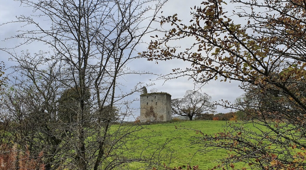
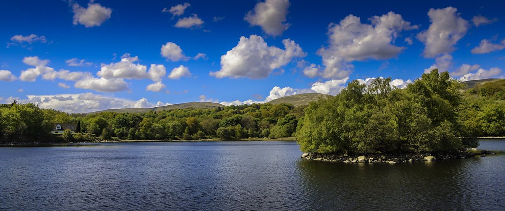
Category Archives: Within a radius of about 20 miles

A walk along the River Leven

Arriving by car by train: The walk starts and ends at Balloch or Dalreoch Station and is easily reached by train from Glasgow

Coming by car: Park in the Balloch Country Park which is on the left just past the Balloch House Hotel (Vintage Inn). To get there, take the A82 (Great Western Road) through Anniesland, along the Boulevard, up the dual carriage-way towards Loch Lomond to the big roundabout which marks the gateway to the National Park. Turn right here (third exit) for Balloch. At the next roundabout, by Macdonalds, turn left (1st Exit) and at the next roundabout turn right (3rd exit) to Balloch.  Drive down through Balloch, past the station, across the bridge over the River Leven and the Balloch House Hotel (on your left) and St Kessogs Church and turn left into Balloch Country Park. It’s about 14 miles from Glasgow and should take about 40 minutes.  

For both forms of transport, you can either take the train to Dalreoch and walk back or  walk to Dalreoch and get the train back. These directions assume you are taking the train to Dalreoch. Alighting at Dalreoch  go over the bridge, exit the station and turn left through the car park sloping down to the River Leven. If the weather is kind you should add in a mile by turning right and following the walkway along the river to  Levengrove Park, Dumbarton, where there are lovely views of the Clyde and the Castle and an old ruined church. If you’re lucky, the toilets at the Pavilion may be open. After this little excursion return up the river to the station car park but keep to the path along the banks of the River Leven. It is tarmac underfoot for most of the way  and makes a good winter walk. Although you pass by some towns this is a surprisingly beautiful walk with the fast-flowing river besideyou all the way.  There are two loops into the river which are well worth exploring but can be muddy. As you approach Balloch there are lovely views ahead to Ben and Loch Lomond. The marina at Balloch is interesting as are the unusual views of the towns you pass – which most of us have known only from the road through them!

If you do Levengrove Park and the loops it’s about 7-8 miles.

An upside down trip to Loch Ard!

Starting Point for the Walk:At the Riverside Car Park in Aberfoyle (NN 521 009).  There are Public Toilets available nearby.

Getting there: 25 miles / 50 minutesTake your favourite route out of Glasgow and head towards Bearsden.  Then take the A809 towards Carbeth and continue onwards eventually turning right onto B834.  Turn left where the B834 meets the A81 and head towards Aberfoyle.  At Aberfoyle turn left at the roudabout onto A821 into the outskirts of the town.  Look out for the brown ’Trossachs Discovery Centre’ signs and turn left into the Riverside Car Park.  Parking is free.

The Walk:  8.2 miles (13 km)The walk starts from the Riverside Car Park in Aberfoyle.  Leave the Car Park via the west exit and then turn sharp left to cross the River Forth onto the Rob Roy Way, heading initially in a south westerly direction along a quiet rural road.  After 0.5 mile leave the Rob Roy Way and head in a south easterly direction along a forest road that skirts the southern edge of Doon Hill.  After a further 0.5 mile, the Forest Road splits into three separate routes. Take the right-turn option and continue for about 0.8 mile in a south westerly direction.  Then take another right-turn and a short series of meanders through the forest, heading broadly in a northerly direction.  In due course turn left to briefly re-join the Rob Roy Way.  [Distance so far = 2.3 miles]

After about 0.1 mile turn right, leaving the Rob Roy Way.  About 10 minutes later turn left, promptly followed by another left turn then a right turn – this is the start of a significant gentle climb along the northern slope of Garbeg Hill.  Soon after the forest road starts to descend Garbeg Hill, there is an extensive ‘open’ area of woodland which gives lovely views of the hills above Loch Ard.  Weather permitting, this would be a good place to have lunch.  [Distance so far = 4 miles]

Continue the gentle descent of Garbeg Hill.  After about 0.2 mile turn right onto the “Statute Labour Road” and continue along it for 1.2 miles.  Note: this was the starting point of the January 2012 walk!!  Then turn left and pick up the path that soon heads west along the north side of Lochan Spling.  Then it is a short climb along the west side of ‘Creag nam Fairenean’ before gradually descending via a series of meanders, across the Duchray Water, duly emerging at the Forest Car Park near the hamlet of Milton.  [Distance so far = 6.5 miles]

From Milton Car Park head to the hamlet of Milton.  The final section is along an (almost) level footpath along the B829 which returns to the Riverside Car Park in Aberfoyle. [Total Distance = 8.2 miles].

Making an Impression

This circular walk from Clachan of Campsie makes use of the Strathkelvin Railway path and is mainly flat but can be a little muddy in places. The route taken is through an area steeped in history, and an industrial past, when Lennoxtown was a thriving village with a print works. It then turns away from the flat path and makes gradually for a viewpoint of the beautiful Blane Valley, and then winds through the grounds of the old Lennox estate with the ruined castle before ending up in the grounds of a peaceful retreat. The adventurous can also walk to waterfalls from the Campsie Hills.

Starting Point:

The starting point is at OS Reference NS 610 795 which is the parking area at Clachan of Campsie.  

Getting there: 16 miles/32 minutes

Take your favourite route out of Glasgow towards the A81 and head for Milngavie.  Continue on the A81 to Strathblane and at the roundabout turn right onto A891 (Lennoxtown).  Follow this road until Clachan of Campsie is reached and turn left (signposted Campsie Glen). Continue up this road (which is a dead end) until the small parking area next to the bus terminus.  There is also plenty of parking on the road.  There is a public toilet (20p) to the right of the small shops. 


Clachan of Campsie, Scotland, United Kingdom

The Walk:  Clachan of Campsie Circular – 8 miles/13 km

The walk is mainly level, on signed paths with one steeper section in the middle.  For those who would prefer a shorter walk, there are various options.

Head back down the road towards the A891 and turn right, crossing the busy road with care to take the signed path (Thomas Muir Way) in the direction of Lennoxtown.  Follow this track which becomes both the Strathkelvin Railway path and the John Muir Trail.  Continue on this until the sign for Glazert Country House Hotel where there are toilets.

After making use of the facilities, return to the path and take the track opposite.  Continue on this as it becomes a little rougher and steeper until a T junction with South Brae is reached and turn left.  Continue uphill until the road evens out and keep going straight on (signed Lennox Forest Walks). Pass a car park on the right and follow the rougher track forward until a fork in the path.  There is a smaller trail straight ahead and this leads towards Blairskaith Muir.  A trig point lies to the right and a distinct path towards it can be seen after crossing a fence. There are great views from here of the Blane Valley towards Loch Lomond and the Arrochar Alps. 

Retrace the path till it returns to the main track and turn left.  Continue down this track, keeping to left at any junctions and passing Lennox Castle (a ruin).  Continue on this path until it becomes the Thomas Muir Way and head towards the A891 but turn left to follow the path along the burn, around the back of cottages to Haughhead and the main road.  Cross the road into Schoenstatt, and take the footpath to the right across the bridge, through woodland, across a second bridge, through a garden and then to the right up to large wrought iron gates.  Turn right out of the grounds onto Knowehead Road.  Follow the road to the end and turn left to arrive at Clachan of Campsie.  To visit Campsie Glen, river and waterfalls, follow path right around the back of the bicycle shop – an extra half mile. 

Drymen in the Highlands

This walk takes you from Drymen along the West Highland Way through Garadbhan Forest towards Conic Hill, descending to Milton of Buchanan and returning via Buchanan Castle grounds.

The ruined country house, Buchanan Castle, was built c1852.  The house replaced Mugdock Castle as the official seat of Clan Graham. Sold in 1925 it was used as a hospital during the Second World War.  The roof was removed in 1954 which accelerated its deterioration.

The walk takes you through the Queen Elizabeth Forest Park which covers some of Scotland’s most-loved locations including Ben Lomond.  Conic Hill, with a summit at at 361m, sits above Balmaha.  On a good day it provides an excellent viewpoint.

Meeting Point:

Take your favourite route towards Bearsden Cross then follow the A811, then B858, to Drymen.  In Drymen turn right at the Green into Stirling Road and the car park is a couple of hundred metres on the right. From Glasgow it’s about 17 miles and should take about 35 minutes by car.

Start at OS Reference NS 475 886 which is the car park in Stirling Road, Drymen.  

Drymen, Scotland, United Kingdom

The Walk: Drymen and Garadhban Forest- 9.0 miles

Turn right from the car park and continue along Stirling Road to the sign for the West Highland Way (WHW).  Turn left and then follow the WHW until leaving the Garadhban Forest.  There are fine views here of Conic Hill and across Loch Lomond.  Next, reverse the outward route for about half a mile until a cross roads.  Turn right and walk past Creity Hall (just a farmhouse) down to the main road at Milton of Buchanan.  Turn left onto the B837 and after crossing a bridge turn right at a way-mark sign onto the ‘Gort Daraich Walk’.  Then turn left towards Buchanan Old House and skirt most of the housing at Buchanan Castle.  Having left the housing behind turn left towards Buchanan Home Farm.  Just before the farm turn right onto a track/minor road through woodland to emerge on the B858.  Turn left and head north towards The Square, Stirling Road and the car park.

Going Forth in Aberfoyle

This walk in Loch Lomond and Trossachs National Park near Aberfoyle will take in the beauty of this part of Scotland.

Aberfoyle is a gateway to the Trossachs and is well known for Rev Robert Kirk and his book “The Secret Commonwealth of Elves, Fauns, and Fairies”.  This book was written in 1681 but not published until much later, 1861. Perhaps he should be equally remembered for an early translation of the Psalter in Gaelic (1684).

The plan is to exploresome of the forest trails to the south of the town.  Aberfoyle has plentiful parking and it is from here that the walk will start.  Public toilets are available near the main car park.

Starting Point:

The starting point is at OS Reference NN 520 009 which is the car park behind the Forth Inn at Aberfoyle.  

Getting there: 25 miles/50 minutes

Take your favourite route out of Glasgow towards Strathblane on the A81 (or towards Carbeth on the A809 and turn right onto the B834 and then left to join the A81 towards Aberfoyle).  At the Rob Roy Hotel by the roundabout on the outskirts of Aberfoyle turn left (A821) and in the town centre turn left at the sign Parking/Scottish Wool Centre.  Parking is free and there are toilets.

The Walk:  Aberfoyle Forest Trails – 9.0 miles (There are options for shorter walks of 2.8/4.5 or 7.5 miles)

The route starts by leaving the car park by the west exit.  Turn left into Manse Road and cross the River Forth onto the Rob Roy Way. Pass Aberfoyle Old Church and Burial Ground on the left, then ignore the road on the left and continue onwards. Bare right where the road splits ignoring the track on the left signed Downhill Fairy Trailand enter Loch Ard Forest.  Continue on and ignore the path on the right.  After a further 100m turn right off the Rob Roy Way.

Continue on this track and at the next junction turn left; then right at the next junction.  At the cross-roads, 1for a short walk turn right and return through Kirkton to the start point.  For the main route continue go straight on and at the next junction turn left.  The track passes Lochan Spling on the left before a short climb along the west side of Creag nam Fairenean.  Ignore the tracks to the left and to the right before gradually descending, via a series of meanders, to cross the Duchray Water. The track then emerges at the Forest Car Park near the hamlet of Milton.

2For the 4.5 mile route turn right towards Milton and pick up the route in the next paragraph. For the full walk turn left from the Car Park and head south west, passing Dalzell Wood on the right, and intermittently parallel the Duchray Water.  Ignoring the tracks going off to the left continue on the forest track as it gently climbs to Lochan a’ Ghleannain.  There is a scenic area at the east end of the lochan.

3For the 7.5 mile route turn right, away from the Lochan a’ Ghleannain, and return to the Forest Car Park and then on to Milton for the last leg of the route (see below).  For the full route, continue anticlockwise around the lochan, ignoring the tracks going off to the right.  Once past Creag Bhreac ignore the track on the left, then at the next junction turn right and shortly afterwards turn left.  As the track approaches Loch Ard turn right and follow this track, often close to the shore, back to Milton.  2,3At the hamlet of Milton turn right onto B829 (Aberfoyle) for the final level footpath that leads back to the starting point.

Turning on the tap

Starting from the north side of Muirsheil Country Park at the Cornalees Visitor Centre the walk follows the good paths of the standard Greenock Cut circular route. The walk is relatively flat. The walk passes 23 stone built bridges as well as two bothies – the latter provided accommodation for the workers who built the cut. The cut opened in 1827 and supplied Greenock with water for industrial and domestic use. It was built by engineer Robert Thom and was replaced by a tunnel in 1971. In good weather there are great views.

Starting Point:
The starting point is at OS Reference NS 246 721 which is the car park at the Greenock Cut Visitor Centre, Clyde Muirshiel Regional Park about 4km east of Inverkip.

Cornalees Bridge, Inverkip 9LX, Greenock Cut, Greenock PA16, United Kingdom

Getting there:  30 miles/60 minutes
Take your favourite route out of Glasgow towards the M8 heading for Greenock.  Just before Greenock either: [1] go left onto B788 signed Kilmacolm/Scenic Route to Largs and continue onto B7054 (Drumfrochar Road); this will by-pass the town centre; or [2] head for the town centre and at the large roundabout just past the fire station go left onto A78 towards Irvine/Largs/ Wemyss Bay and Isle of Bute Ferry.  If option [1] is chosen continue to the roundabout and go left onto A78 towards Irvine/Largs/Wemyss Bay.  Continue on the A78 past the site of the old IBM factory and look out for a sign pointing left to Loch Thom and Greenock Cut Centre and go left onto a narrow road (Dunrod Road).  After crossing the bridge over the railway line there is a stretch of straight road.  Look out for the Loch Thom sign and at the obvious ‘Y’ junction take the left fork.  Follow the road to the Visitor Centre.  Parking is free and there are toilets but these often have restricted opening times.

For a more scenic route, which may take longer, take B7054 (as above), pass the Broomhill Tavern and after entering a 20mph speed restriction area turn left just past a sign for Scenic Route to Largs/Greenock Cut Centre into Drumfochar Road*.  Continue on this road and shortly after it bears left, and just past a school entrance on the right, turn left (Old Largs Road).  At a junction (to Whinhill Golf Course) bear right.  The road continues to climb.  Ignore the small finger sign (Corlic Hill) pointing left and further on ignore the road on the right.  Views of various lochs will now be visible.  The road skirts Loch Thom.  Turn right just past a sign to the Greenock Cut Centre.  Cross the bridge and continue along the other side of Loch Thom to the Visitor Centre.
*If this left turn is missed continue ahead (Cornhaddock Street) and at the traffic light junction go left.  Then go over the railway line at Drumfrochar Station and at the next junction go right onto Drumfrochar Road.  After a short distance, and just past a school entrance on the right, turn left (Old Largs Road) and continue as above.

The Walk:  Greenock Cut/Shielhill Glen Nature Trail – 8.25 miles
The walk starts at the car park and follows tracks and paths, the surfaces of which should be reasonable throughout.
From the car park go left and follow the track past the Compensation Reservoir and Loch Thom.  Just before Overton turn left to follow the main aqueduct.  At Shielhill, not far from the end of the walk, cross the road to take the path opposite.  After about 250m go right to follow the Shielhill Glen Nature Trail through woodland.  The path crosses a stream (ultimately the Kip Water) on several occasions before exiting the woodland.  Continue on this rising path and turn left when it joins the Kelly Cut.  Follow the Kelly Cut back to the road and turn left towards the Visitor Centre and the car park.

Going with the flow

This is primarily a forest walk starting midway between Drymen and Aberfoyle. The walk follows the High Corrie Trail which heads into Loch Ard Forest. The route crosses the line of one of the two tunnels that have been carrying Glasgow’s water supply from Loch Katrine to Milngavie since Victorian times. There are plenty of clearings in this Forestry Commisson area which provide open views of the surrounding countryside. Weather permitting, this should include the Carse of Stirling and the Ochil and Gargunnock Hills as well as the Menteith Hills and Ben Ledi.

Starting Point:
The starting point is at OS Reference NS 506 935 which is the car park near Drymen Road Cottage.

Glasgow G63, UK

Getting there:  20 miles/50 minutes
Take your favourite route out of Glasgow towards Drymen.  Enter Drymen on the B858 and ignore the staggered crossroads.  Just past the green on the left, and as the road bends round to the right, go straight ahead onto a minor road (the Old Gartmore Road which becomes the Old Drymen Road) towards Dalmary and Gartmore.  After about 3.5 miles there is a parking area on the right just before Drymen Road Cottage.

The Walk:  High Corrie Trail  – 9.0 miles (Option:  4.5 mile)
The walk starts at the car park and follows Forestry Commission LRTs.  The surface should be reasonable throughout.

Cross the road from the car park and take the left hand path, NOT the Rob Roy Way.  At the first junction go right.  Follow this path until the Lossnaugh Burn has been passed.  At the next junction go left for the full walk or right for a shorter walk.  On the shorter walk at the next junction ignore the path on the left.  Turn right when the path meets the Rob Roy Way and follow it back to the car park.

For the full walk ignore the path on the right (the shorter walk) and continue on the path ignoring the paths on the first right, second left, third left, fourth left and fifth left.  At the next junction turn right and after 0.5 mile cross the Corrie Burn.  After crossing the burn the path swings round to the left.  With the Corrie Burn on the left follow the path until High Corrie.  At the eastern perimeter to this property ignore the path on the right.  Continue until the path meets the Rob Roy Way near the Corrie Aquaduct and turn right.  Ignore the paths on the first left and second right (where the shorter option joins the Rob Roy Way).  The path leads back to the car park having passed an aqueduct, Corrie and a second aqueduct.

Frontier of the Empire

Starting Point:
The starting point is at OS Reference NS 720 767 which is the rear car park at the Boathouse Restaurant.

Kilsyth, Glasgow G65 9SG, UK

Getting there:  16 miles/30 minutes
Take your favourite route to the M80.  Exit at Junction 4A, using the left hand lane to exit towards Kirkintilloch/Kilsyth /B8048.  Keep left and follow signs for Kirkintilloch/Kilsyth /B8048/B802.  At Back O’ Hill roundabout, take the 2nd  exit onto B8048.  At the next roundabout (Craiglinn) take the 3rd exit (continuing on B8048) and at the next roundabout (Blackwood) take the 3rd exit onto B802 (Howe Road) signed Croy/Kilsyth.  Stay on this road for about 1.5 miles.  At the next roundabout take the 3rd exit for Auchinstarry Marina.  The Boathouse is on the left.  Please park behind the Boathouse; there is plenty of parking.

The Walk:  6.5 miles (Shorter option available)

Take the path up behind the toilets and go through a gate onto the road.  Turn right to cross the bridge and take the path down to the canal on the right.  At the canal turn right to go under the bridge.  Follow the canal path and at Twechar turn left over the canal and follow the road up hill.  Just past the war memorial turn left (signed Barhill Fort/Antonine Wall /John Muir Way) where a track goes uphill.  Keep right where it forks and turn left at the kissing gate (with John Muir Way sign).  Pass through the next gate and head diagonally uphill to reach the remains of Bar Hill Roman Fort.   The fort garrisoned about 500 men, and is located slightly south of the Antonine Wall (built c140 AD).

After exploring the fort continue ENE (from the top of the fort), to pick up a grassy path that soon climbs to the top of Castle Hill.  This is the site of an iron-age fort.  Continue on the grassy path, which curves slightly right, to join the edge of the ditch of the Antonine Wall which was built by the Romans as a northern replacement of Hadrian’s Wall.  Passing an area of forestry on the right, continue until a stone wall (with a sign about the wall) and turn right.  Shortly after turn left along a track.  At a gate continue ahead and, likewise, at a later junction.

Anyone wanting a shorter walk can take either the marked footpath to Auchinstarry, or continue to the road ahead (B802) and walk back via the pavement.

At the B802, cross the road and go through a kissing gate (adjacent to a tree) and follow the path straight ahead.  Turn right at a fenced enclosure, following a surfaced track for a short distance, then turn left after a gate signed Croy Hill.  Continue ahead to reach a path and then another gate marked Croy Hill.  Continue on the grassy path that follows the line of the Antonine Wall.  The ditch is prominent on your left and in parts was cut through solid rock.  Keep left when the path forks and climb a mound formed from material dug from the ditch.  The remains of the fort are not obvious but the two nearby platforms may have been used for signalling.  Carry on along the path on top of the ridge, from which there are excellent views, and then straight ahead crossing a path (the site of the fort itself was just to the right) towards a marker post.  Next, pass a ground-level information board about Croy Hill.  The site has been excavated twice and found to comprise two forts (one superseding the other as the plans for the Wall changed during the two years of construction) and a bath house just outside one of the forts.  Remains of a civilian settlement in Roman times has also been found.  It was probably established to trade food and services with the Roman soldiers.

Continue downhill, passing under the electricity lines and turn left onto a path signed for Castlecary.  Ignore the next turn right, signed for Castlecary, and instead go past the picnic benches to take the next path on the right which heads downhill through trees (with views of the canal) to emerge on a minor road.  Turn left and cross the canal, then turn left onto the canal towpath.  At Auchinstarry cross the road bridge back over the canal to return to the cars.

Lanark Loch, Falls of Clyde and New Lanark

There is parking at Lanark Railway Station but, apparently, there are no toilets and parking is for rail users only. The public toilets are in either the South Lanarkshire Leisure Harry Smith Centre or the South Lanarkshire Leisure Swimming Pool both of which are in Thomas Taylor Avenue behind the Rail and Bus Station so it would be best to find a parking slot somewhere along there.

You are following the ORANGE route on the Tourist Information Leaflet. The distance is a maximum of 9 miles and follows tarmac roads, gravel footpaths and a grassy racecourse. There are a number of steps – no stiles. A couple of sections are along the edges of roads open to traffic.

To get there the shortest route still seems to be:

Take the M8 east towards Edinburgh and then take the M73, quickly followed by the M74 towards Carlisle etc.  (At junction 7, on the M74, take the A72 down the Clyde valley. Continue on through Rosebank, Crossford, and Kirkfieldbank where you climb up a steep hill to a really nasty junction with the A73. Here turn right, go up the main street through the town centre and at the junction at the top (at traffic lights), take the right hand road towards the station. Turn left along Woodstock Road, just before the station, and right along Parklands Oval which becomes Thomas Taylor Avenue running parallel with the station.

The Satnav code for both Leisure Centres is: Thomas Taylor Ave, Lanark ML11 7DG

Walk back to the Railway Station.

UK


From Lanark railway station turn left along Ladyacre Rd away from the town centre. Beyond the tourist info turn left into Whitelees Rd. Follow for ½ mile. At Lockhart hospital continue straight on. Just beyond the hospital as the road goes to the left, go up a short slope ahead onto a disused railway. Follow the path to the car park at Lanark Loch. Leave the railway path and descend to the loch.

Go around the loch in a clockwise direction until you reach a steel and concrete bridge. Take the next left and follow the footpath uphill to the equestrian centre.

To go around the racecourse follow the road to the left of the equestrian centre and follow the obvious circuit to return (adds about one mile).

(Just seven years after the first powered flight, Lanark racecourse hosted what was only the second international airshow in the UK. More than 200,000 spectators gathered to watch and a new railway station had to be opened. The event is commemorated in a public artwork at the entrance to Lanark Loch. The redbrick tote and the outline of the circuit is all that remains of more than seven centuries of racing at Lanark. One of the races that ran at Lanark was the Silver Bell. The winner received a trophy that dates back to the early 17th century.

To continue with the route go to the main road and turn left.** Walk for about 50 yards before crossing the road that leads to the Scottish Power Bonnington Power station. Follow the road lined with beech to Robiesland farm. At the end of the tree-lined section follow the road round to the left and continue downhill following a sweeping bend to the power station. For visit to Corra Linn turn left and follow footpath uphill to viewing area (5 mins.)

(At more than 90 feet high the Corra Linn is the highest of the four Falls of Clyde and one of the most powerful in Britain. Above the viewing area is a perfectly positioned pavilion. Once lined with mirrors, anyone standing at its centre felt as though they were at the centre of the Falls. The Corra Linn has been visited by William Wordsworth, numerous crowned heads and painted by JMW Turner. Be on the lookout for the fast moving peregrine falcons that nest on the cliffs.

The village of New Lanark and its tiers of mills and tenements is an impressive site as you reach the end of the river walkway. Begun in 1786 by Richard Arkwright and David Dale the village would later be renowned for the innovative employee welfare programme initiated by Dale’s son-in-law Robert Owen. The village is now a UNESCO World Heritage site.)

Go through the arch and follow the canal on your right through New Lanark. At New Lanark hotel hook round to the right and then turn left to go through main gates. Turn left uphill past the red telephone box.

Close to the top of the hill but before the bend, turn left to follow the Clyde Walkway. Continue along the walkway to the viewing platform and then over the suspension bridge. Descend the steps to follow the Clyde downstream. The path eventually climbs in a series of bends uphill to Castlebank Park.

Turn right in the park and continue to the play park. Follow the footpath to the left of the play park uphill across a grassy area. (Castlebank Park is in the process of being refurbished … it now has a Horticultural Centre, renovated and replanted gardens, William Wallace Memorial Rose Garden, Sculpture Trail including a 7 ft high Wallace wooden sculpture and a bog garden.)

(Lanark Thistle bowling club, on the top edge of the park, now occupies the knoll on which stood Lanark Castle. In 1297 Wallace attacked the castle and killed the sheriff.)

Turn left at the gatehouse and once through the gates turn right and follow Castlegate uphill through Lanark’s historic core to St Nicholas’ Church. Turn right and follow the High Street uphill to return to railway station

**Shorter Walk – go to main road and turn right. Following the pavement, you will pass the entrance to Lanark Loch and the “Spirit of Flight” Air Show Memorial. Further on you will see on the left, the old Cemetery with St Kentigern’s ruins where Wallace and Marion Braidfoot were married. Keep straight on down the Wellgate to arrive at St Nicholas’ Church at the bottom of the High Street. Turn right, and continue on right, back to bus/ rail station.

The Semple Trail

To get there
Take your favourite route out of Glasgow (probably via the Clyde Tunnel) to join the M8 towards Greenock.  Exit the M8 at Junction 28A onto the A737 going south towards Johnstone.  Continue past Howwood and turn right onto A760 (Lochwinnoch).  At the box junction turn right into Lochlip Road (over Calder Bridge).  Continue until the sharp left hand corner where you turn right into the car park.  Parking is free.

The Walk:  The Semple Trail – 10.0 miles (Options:  5.0 miles from Howwood; short additional extensions)

The walk starts at the car park and is well signed.  Follow the cycle track southwards to the end of Castle Semple Loch, cross the bridge and turn left .  The track joins the pavement just before the RSPB reserve.  Continue on the pavement over the railway bridge at Lochwinnoch Station, past The Loch House (where we will be eating) and up to the roundabout at the junction with the A737.  Carefully cross the A737 and take the small road opposite.  The road climbs gently to Belltrees Road where you turn left. Continue on this road past Newton of Belltrees until High Trees where you take a smaller track to the right. Follow this country track to the end and go through the gate opposite onto a grassy path with the sound of the Linnister Burn to the right.  Cross the burn using the bridge.  The path gently climbs to join a minor road at North Muirdykes.  Turn right for 200m and then turn left onto the B776 and follow the pavement downhill.  On a good day there are wonderful views across the valley and to the mountains to the north.  Just past the Catholic Church (on the right) take a small path to the left (signed Beith Road).  This joins the B787 (Main Street) at the Church of Scotland.  Cross the road and turn right for 100m and follow the road left (Station Road) towards the railway station.

Continue on this road over the railway line, the main road and Black Cart Water.  Just past a parking area on the left turn left over a stone style to follow a track across farmland.  Note the Temple on the hill to your right which can be accessed by an optional detour once the track swings to the right as it approaches the north end of Castle Semple Loch.  Follow the path until it joins the cycle track (NR7) at a gate and turn left towards Lochwinnoch.  Cross the bridge at Castle Semple and take the path down to the right.  At the gate turn left.  Pass and/or visit the Collegiate Church which is on your left and the cascades on the right.  Continue on this track until an obvious split.  Go right through a gate and into woodland (Parkhill Wood).  Take the first obvious path to the right and follow this (generally keeping right when there is a choice) as it climbs and wends its way through the trees.  The path skirts the northern edges of the wood with views over the trees below.  Where the path splits at the southern end of the woodland take the path that rises slightly to the left and then another rising path to the left shortly thereafter.  The gentle climb takes you to a Lookooterie (a lovely viewpoint) on Parkhill.  Follow the path down the other side of the hill.  There is a short stepped section before the path swings left.  At the path junction turn right and almost immediately right again towards the Grotto.  Follow this path to the bridge that crosses Blackditch Burn and turn right.  Exit the wood through the gate, cross the cycle path, and walk down to the loch side.  Turn right and follow the track back to the cars.

Keep your eyes open: Interesting artwork/seats.  Historic buildings, including a folly; the cascades; the ice house.  Butterflies and birds.

Après-walk Meal: Arrangements have been made for a meal at The Loch House.  The ‘menu’ is attached for information purposes only.  It includes parking arrangements, directions and time.  Meals cost from £9.50.